
VIDEO:
Introduction
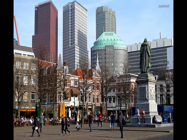
The Hague is the third-largest city in the Netherlands, home to over 500,000 people, several major companies, an abundance of museums and tourist destinations, and most national government offices. Its downtown is a vibrant commercial center which contains over 100,000 jobs and is full of commuters and travelers from around the country and around the world. The downtown area is also a major cultural center in the Netherlands, featuring most of the city’s retail, attractions, and street life. This is sustained by the dense, medieval street network which ties it together and promotes pedestrian activity by its design.
If you were to visit the Hague Center today, you would notice that most streets are full of pedestrians and bicyclists during the day, but you would notice few, if any, cars in the area. This was not always the case, and the neighborhood’s current state with regard to traffic is no accident: Automobile use has been largely excluded from the Hague’s vision for its city center, which affects all of the neighborhood’s residents and visitors, and has the potential to permanently change the city’s culture.
In the decades following the second World War, the automobile dominated the world of transportation in the Netherlands, as most Dutch people became wealthy enough to own them. Viewing automobile travel as the way of the future, Dutch planners, like those throughout Europe and the West, set out to make all roads accommodating for car travel (i.e. wide roads, multiple lanes, and maximizing car throughput however possible), which had the effect of damaging the safety of pedestrians and bicycles while inducing additional traffic that negated attempts to streamline it.
Downtown The Hague was no exception to this phenomenon: In the 70’s, public squares were turned into parking lots, cars had access to even the narrowest city streets, and the district’s main streets were transformed from attractive boulevards into traffic sewers. The widest streets in the area were Grote Marktstraat and Spui, which were the main East-West and North-South streets in the district, respectively. With the advent of car-based planning, they became the main thoroughfares of the city: These streets were not originally designed for car travel, of course, and when they were redesigned to include two lanes of traffic in each direction, they began to carry more traffic than they could handle. Daily traffic jams during rush hour became inevitable, and the mixture of intense car traffic with bicycles, mopeds, buses, and about a dozen surface tram routes made these main streets simply unpleasant to navigate.
These most acute problem with these streets, however, was not the congestion which made them inconvenient to travel on. By the 1990’s, the central district of the Hague had the most polluted air in the Netherlands, largely due to the intense, stagnant traffic that passed through it every day. It was this issue that Dutch planners sought to mitigate over twenty years ago, leading to major changes in the way that the city handles traffic.
Beginning in the late 1990’s, The Hague began closing off large sections of its city center to automobile traffic. This change involved preventing cars from entering most of its narrower streets without a permit, making cars guests on mixed-traffic or low traffic streets, and completely changing the character of Spui and Grote Marktstraat. The city accomplished this in parallel with the designation of an inner ring road and an outer ring road for crosstown traffic, so as to eliminate the need for through traffic through the city center. The concept dictated that certain sectors of the city were closed off to traffic from one another, making it impossible to get from one part of downtown to another without accessing the inner ring road. This removed the noise, pollution, and safety threat of fast motor vehicle traffic from downtown without either preventing motorists from getting to their final destination or adding significantly to the travel time of crosstown drivers. In short, the ring road was designed as an attractive alternative for drivers, which helped to ensure the attractiveness of the city center.
This initiative sought to make the neighborhood more pedestrian friendly, and was supported by efforts to strengthen the city’s bicycle network and prioritize its transit. All of this was vital in reducing potential traffic and making other transportation alternatives more appealing to commuters. By reassigning the functions of most of its downtown streets, controlling the types of traffic which move through it, and promoting “All But Car” transportation, it illustrates the systematic safety principle of Functional Harmony, and provides a case study for how this design principle can succeed.
Functional Harmony
Functional Harmony is one of the Dutch principles of Systematic Safety, which outline how street design can proactively prevent automobile-related accidents. This principle in particular deals with how streets can be designed in a way that is compatible with their intended use, which innately makes them safer and more attractive. For example, an urban street which contains several shopping destinations in close proximity to one another is likely to not only attract significant foot traffic during certain hours of the day, but it is likely that those pedestrians will want to cross the street and walk up and down the street between destinations. Such a street would be incompatible with its function if it carried two wide lanes of traffic in each direction, which would effectively make it impossible for pedestrians to safely cross the street midblock.
Such a need for deliberate road design exists in the center of The Hague, where several factors make through traffic unappealing. First, the fact that so many retail stores, restaurants, and cultural attractions are concentrated in the area (especially on the main streets Spui, Grote Markstraat, and Noordeinde) makes safe pedestrian movement imperative. Second, the fact that so many stores in the area rely on pedestrian activity for business means that they will need their storefront area to look as appealing as possible, and through traffic can easily damage the attractiveness of an urban retail space. Third, dozens of streets in The Hague center are too narrow to safely support car traffic, especially when their width makes bidirectional pedestrian and bicycle traffic appealing. If a stream of cars were to use a series of narrow, old roads in The Hague as a crosstown cut-through, even at low speeds, it would be potentially unsafe to even walk out of one’s apartment and cross the street.
On a large scale, as mentioned, the goal for The Hague’s downtown was to remove all through traffic and keep cars in the area strictly for local traffic. This was accomplished using two tactics. The through traffic in the area could simply be discouraged by making the pathway of a crosstown driver so windy and indirect that it takes longer than using the ring road would have been. The through traffic can also be blocked, by installing barriers that make travel by cars at certain junctions impossible. A combination of these two strategies has been used in The Hague, with sectors having been formed by barriers at key intersections, forcing traffic outside the ring road to remain in a confined space. This design will be discussed in greater detail later in this post.
The design of sector-like divisions within the Hague’s central area is supported by street design that communicates the street’s function. Known as the “room” effect, the design of certain streets should let drivers and other users of a road know what type of traffic and what speed of traffic it should carry, similar to how a person would know what a room of someone’s house serves, just by walking into it. Using geometry and space to influence the behavior of drivers is critical in yielding the results that keep the area safe and easy to travel within (inasmuch as it becomes apparent to drivers to use the ring road for most of their travel). In the video at the top of this post, the types of streets which can be found in the Hague are listed and described, with some additional attention given to anomalous streets.
Finally, the success of a city in implementing Functional Harmony largely depends on demand for access versus accessibility. If a city center, such as the Hague’s, will have to accommodate a large number of commuters and tourists every day, a balanced mode share must be envisioned which compliments this large quantity. Thus, if it becomes inconvenient for many drivers to enter the city center with their cars, an improvement of public transit service may encourage some to stop driving there altogether, and may encourage others to drive less often. The streets Grote Marktstraat and Spui highlight this very accurately. The Hague’s tram system is extensive, and almost all of its lines converge along either Grote Marktstraat or Spui, along which several stops serve the center city.
When the Hague overhauled the design of its center city, it included a redesign of these streets with respect to their capacity to carry public transit. Grote Marktstraat saw its trams moved underground to an exclusive tram subway, between Grote Markt and Spui, when it became a wide boulevard for pedestrians and bicyclists. This is because, even when car traffic was removed, tram traffic was incompatible with the large amounts of disorganized pedestrian activity desired there. Through most of their course, the Hague trams run at about 12 miles per hour, and they would need to lower their speed to about 5 miles per hour in order to be safe in a pedestrian-dominated space. This would be ineffective in getting commuters to their destinations quickly, so it was decided that the trams’s dedicated right of way would be underground. Just beyond Spui, the trams continue in their own right of way which becomes elevated and runs through the Hague Central station, reinforcing multi-modal connectivity. It was also decided that buses would not be run down the street: The HTM bus 25 was truncated at the Grote Markt stop, where commuters can transfer to the subway to get farther down the street.
However, retail does not flank both sides of Spui, and the road can sufficiently carry tram traffic along with bicycle and pedestrian traffic in the absence of cars. Many blocks on Spui are long and dominated by single-function buildings, with a brief exception near Grote Marktstraat, which makes midblock crossing a much less frequent occurrence, and making it safe for the street’s tram right of way to stay on the surface.
A Closer Look: Visualizing the Grid of the Hague Center
As previously mentioned, the Hague divides its center into sectors which are not formalized but implicit: Physical barriers prevent car traffic from exiting circuits which lie on each corner of the neighborhood, with the exception of those few vehicles which are permitted.
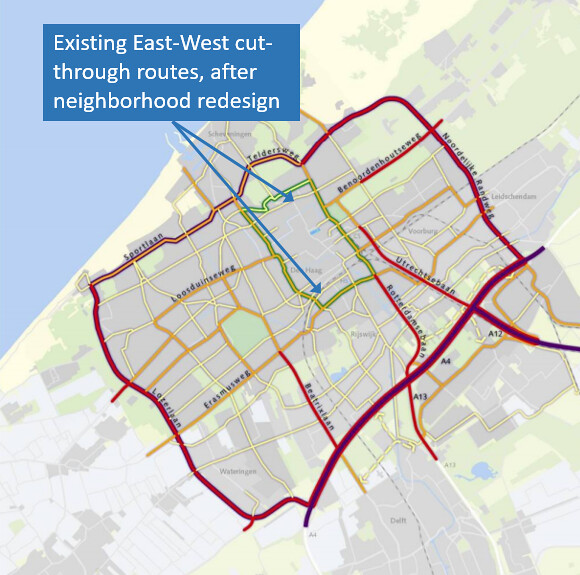
Pictured above is Hague’s Ring Road plan, where the city’s circumferential ring road is shown in red and its Centrum ring road, S100, is shown in green. Within the green ring, there are streets highlighted in yellow, which are entry and exit points for cars between the ring road and the city center. The light grey lines inside the inner ring road roughly correspond to the barriers which form the neighborhoods sectors – these are created by placing bollards on one or both ends of the corridor to prevent traffic from entering, by designing one way streets to face one another, or by placing bollards at the intersections between main streets and some side streets. Some of the city’s canals, which are already physical barriers, serve as barriers to traffic by more stringently regulating one-way travel.
Theoretically, if a driver’s destination within the center city is across one of the barriers, they must drive to the ring road, and access the destination’s sector via one of the yellow streets. This works well in most of the neighborhood, but unfortunately, there are still some cut-through opportunities built into this plan, some of which are visible in the above map. For example, the map shows a yellow line running right through the center city, just south of the upper ring road. This street is Laan van Meerdervoort, which carries eastbound traffic from outer neighborhoods to Javastraat, which itself runs farther East of the city center. Laan van Meerdervoort and Javastraat both have two-way sections, but only carry continuous eastbound traffic, so through traffic is only possible in the eastbound direction.
Similarly, an east-west cut-through route exists in the southern section of the Hague center, as shown by the yellow line which runs just south of the railroad tracks. This significantly affects the north-south traffic on Rijswijkseplein, which it feeds into, and makes the entire neighborhood which surrounds it less attractive and pedestrian friendly.
https://flic.kr/p/WgoBG9
The map above is taken from a Google Maps screenshot, showing traffic conditions on most roads in the Hague Center during the morning rush hour (8:50 AM). While traffic is moving quickly on most parts of the S100 shown, traffic is slow on most of the cut-through routes (like Parallelweg and Mauritskade), a result of a mix of local and through traffic that these streets were not designed to handle. This shows that, while the Hague has certainly made momentous progress toward eliminating unnecessary through traffic in its city center, it is still far from having done that.
Downtown Boston: An American Application
Being very similar in size, and being the center of activity in a similarly sized metropolitan area, downtown Boston is a strong American analogue of the Hague’s city center, and an area in dire need of similar street design reforms. It currently carries highway traffic in four directions through many of its inner neighborhoods on Interstate 90 and Interstate 93, and both of these highways are capable of connecting to the other highways near to the city, like Storrow Drive, Memorial Drive, Morrissey Boulevard, and U.S Route 1. Aside from these dedicated highways, there are several streets in Boston’s downtown area which were once either local roads or neighborhood principals which were redesigned to be thoroughfares in the 1970s and 1980s (like Tremont Street, Charles Street, Essex Street, and Cambridge Street). This was largely due to a more car-centered approach to street design in the city after a moratorium was placed on freeway building in 1972 by then-Governor Sargent, and set the precedent for Boston as a city which is car-friendly but still mired by traffic, as many of the aforementioned streets carry spillover through traffic from the highways, as well as the local traffic which has no other choice but to use them.
As was the case for the Hague 20 years ago, all of these opportunities for cut through traffic jeopardize the safety of local cyclists and pedestrians, as well as the livability and beauty of the downtown area. Below is a snapshot of a Google map containing traffic information for downtown Boston in the afternoon rush hour. In addition to the highway traffic being slow, there seem to be some trouble spots near Berkeley and Arlington streets, as well as in the Theater District, where Boylston, Stuart, Charles, and Tremont Streets carry a significant amount of traffic between neighborhoods in the city.

However, the whole city seems to have issues with slow traffic during rush hour, which should not be, considering how short, windy, and indirect many of Boston’s downtown streets are. One would expect that, on these local streets, there would only be traffic due to deliveries, driving to and from one’s home, and retail and restaurant-driven traffic, which should not lead to a street grid which looks like the one above. The above state of traffic suggests that cut-through traffic has become such a significant occurrence within the city that it has diffused beyond the road which are expected to carry some through traffic.
How can this be solved? Notwithstanding the fact that some of these wider neighborhood principles may have some road diets in their future, there are still roads in downtown which need to carry more traffic than the average local street. In addition to demoting a few streets and applying traffic calming to others, the main solution to this problem appears to be using sectors to completely cut off through traffic between certain areas without first accessing any of the nearby highways. There is a relatively continuous stretch of highway running through downtown whereby a driver can enter Storrow Drive near the intersection of Arlington Street and Boylston street and exit Interstate 93 near Kneeland Street and South station, and only minimally travel on local streets before and after this. Travel patters like this can essentially be forced if physical barriers and one-way diversions made it impossible for drivers to cut from one downtown neighborhood into another using local roads.

Keeping this in mind, the image above shows the basic concept of what such a traffic scheme might look like. Each of the shaded sectors can be sectioned off, with boundaries making it impossible to travel from one to the next, with the exception of certain permitted vehicles and emergency vehicles. The sectors chosen were based on existing neighborhood identity, such as in North End and Beacon Hill, as well as the usefulness of having certain locations accessible to one another (such as the Financial District east of Congress Street, and the Government Center-Haymarket Complex). Discussing which streets would serve which function in this case would be too complex, but a concept like this would be feasible if public transit within and going out from this area were made more robust and more accessible, with more frequent rapid transit service and train service being one such solution. The inconvenience brought out by the physical barriers which separate neighborhoods will inevitably add traffic to the “ring road” of highways in the short term, but will ultimately reduce traffic in the city overall by inducing the convenience of other transportation alternatives.