
HW4 Delft Lindsey Vazquez
BIKE LANE
Bike lanes are a simple and cheap way to provide cyclists with a distinct path and provide drivers with a known barrier as well as separate the two types of vehicles. The Dutch only utilize bike lanes in specific situations: if the road is 1+1 with no parking, if the road is 1+1 with low turnover parking, and at divided 2+2 lanes with no parking. These design situations most commonly arise when there is limited available right of way due to historic constraints such as existing infrastructure.
Site 4 – Buitenhofdreef
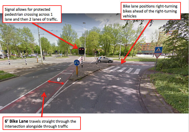
Design/Safety: The above intersection at Buitenhofdreef contains high motor vehicle traffic for the bicycle facility that they choose to utilize: a bike lane. The surrounding neighborhood contains high-rise apartments, buses and trams also travel through this intersection, and the travel speeds appeared to be faster than 30 km/hr at which the Dutch typically require a separated bike facility. Though the current bike facility feels relatively stressful, a couple safety features made this intersection a little less terrifying. Shown above is a right turn lane with a bike lane just beyond the motor vehicle yield arrows. The placement of the bike lane ahead of and in simple view of the driver makes that right turn or through movement for the cyclist much safer. The continuation of the bike lane and red asphalt alongside the motor vehicle traffic also really distinguishes the bicyclist zone from the motor vehicle zone through the intersection.
Site 9 – Nassaulaan
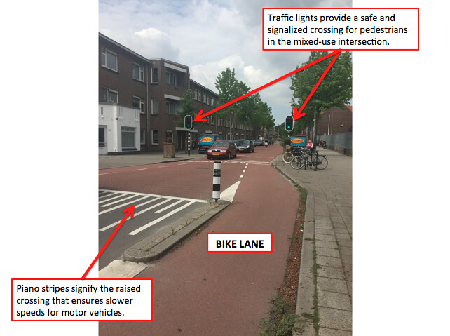
Context: The above street, Nassaulaan is in a residential neighborhood with a lot of on-street parking and roaming pedestrians. The right of way is limited due to existing infrastructure and the design speed limit is < 30 km/hr which meets the criteria for a dutch bike lane alongside a travel lane. Additional measures were taken in order to ensure that the motor vehicles on the street drove at slower speeds. The designers narrowed the travel lane and added a raised crossing table with stamped red asphalt to make the motor vehicles aware that they were in a mixed-use zone. Traffic lights were included at the crossing table to provide a safe, signalized crossing for pedestrians across both a motor vehicle travel lane and bike lane.
Site 10 – Julianalaan
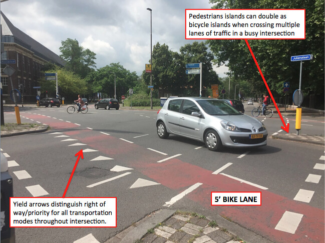
Design: The use of bike lanes here suggests that the original design for the intersecting street was for motor vehicles with 4 lanes of through traffic. The Dutch are known for their street “demotions” and converted this 2+2 street to a 1+1 with bike lanes on both sides. I, personally, find it very stressful to ride through an intersection alongside a vehicle, but with the bike lane clearly marked and the stop line ahead of the neighboring motor vehicles, I felt that it was very clear where I was and where I was going to go throughout the intersection. Additional pavement markings and signage also helped with distinguishing priority and direction in a complicated intersection.
BIKE BOULEVARD
A bicycle boulevard, also known as a neighborhood greenway or neighborhood bikeway utilizes a lower-speed local street to give priority to bicycle through-going traffic as opposed to motor vehicle traffic.
Site 1 – Beatrixlaan
Context/Safety: Bike boulevards are often found alongside canals because canals used to be the most direct and efficient way of traveling so it made sense to build main roadways for motor vehicle through-traffic along that same route. The image above is an example of that practice. The Dutch converted a through-traffic roadway into a bike boulevard primarily for bicycle and pedestrian use. The red asphalt and red brick pavers signify a bicycle facility and the gray brick/cobblestone are pedestrian walkways. Bike boulevards, because they were main roadways and alongside a canal had few crossing points to the other side of the canal; at this specific location, there’s a bridge to connect to the other side of the canal. The bridge height is low enough for cyclists to ride over comfortably but high enough for smaller boats to travel under without having to raise the bridge.
Site 5 – Buitenwatersloot
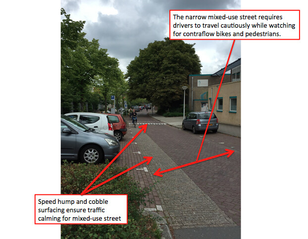
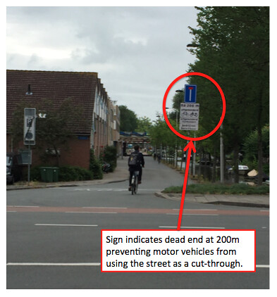
Context/Design: The bike boulevard above was initially a major roadway for motor vehicle through traffic alongside a canal. The Dutch built a highway a few blocks over and decided to re-design the old cut-through roadway to promote pedestrian and bicyclist use over motor vehicle use. At one end of the street (see above), they resurfaced the street from black asphalt to layered brick and included speed humps to slow the residential motor vehicle traffic that had to utilize the street and discourage through traffic from using the mixed-use street. The other side of the street (see below) split the street in half and placed dead ends about 200m in so that residential traffic could get to their homes, but through traffic would need to find another route. This deterrent minimized motor vehicle traffic volumes and allowed for the street to remain a smooth black asphalt for cyclists and pedestrians to utilize.
CYCLE TRACK
Cycle tracks are horizontally or vertically separated bike lanes where the adjacent motor vehicle traffic is travelling at speeds greater than 30 MPH. The degrees of separation for cycle tracks can very depending on the available right of way and the safety concerns developed by motor vehicle traffic. Cycle tracks can be separated horizontally using a parking lane, buffer zone, or landscaped median, or separated vertically by raising the cycle track to curb height. Cycle tracks can be designed as one-way or two-way though they both provide advantages and disadvantages at select conflicts.
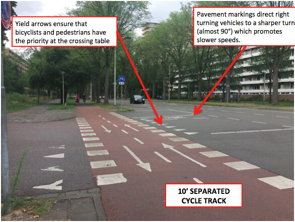
Site 2 – Papsouwselaan
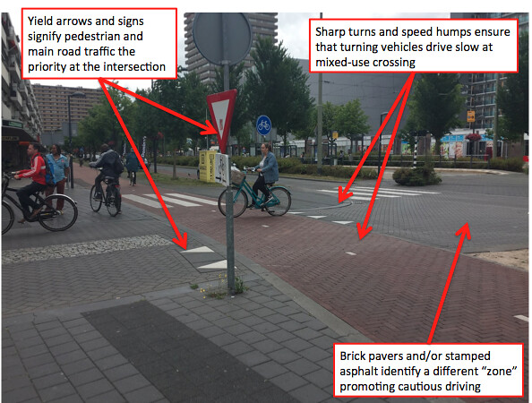
Context: The surrounding neighborhood is very commercial; there are grocery stores, shops, and apartment buildings lining both sides of the street. These facilities would produce a lot of motor vehicle traffic and would define the road function as a distributor. A distributing road has speed limits over 30 MPH and requires a separated, either horizontally or vertically, bike path or cycle track (shown above). Additional design constraints were applied where the motor vehicle traffic mixes with pedestrians and bicyclists at crossing tables. The pavement surfacing varied from black asphalt to stamped asphalt and the turns were designed at almost 90° to slow down the motor vehicles.
Site 3 – Voorhofdreef
Safety: I would consider this type of bicycling facility extremely safe. The cyclist is horizontally separated from the motor vehicles with a fully landscaped median as well as vertically separated by the 6” curb height and thereby eliminating any motor vehicle concern for the cyclist. The cycle track is also separated from pedestrian traffic by a fully landscaped section. The signage throughout the bike path and particularly at the intersections was very clear and descriptive and I could always distinguish who had priority. This would be a bicycle facility that I would feel comfortable riding with young children.
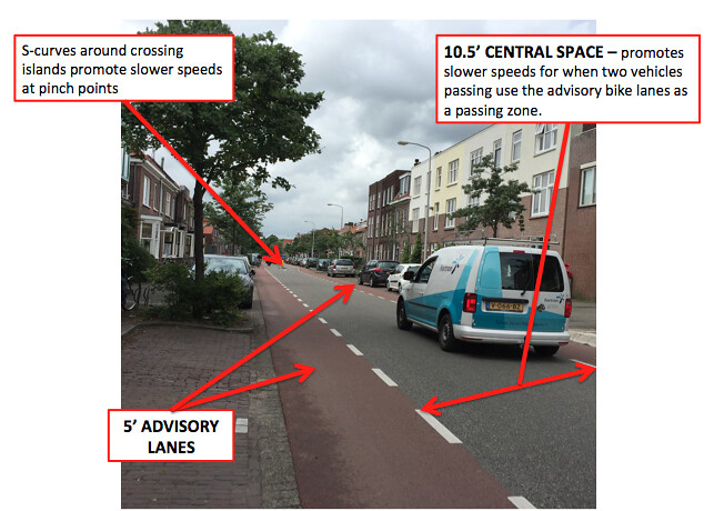
Site 8 – Ruys de Beerenbroukstraat
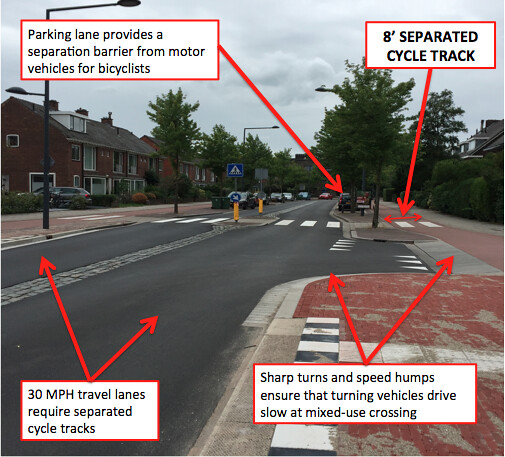
Design: The street was designed for 25 MPH speed limits which falls under the “grey” street and requires a separated cycle track or bike lane. From the centerline is about a 2-foot cobble stone median, then a 9-foot wide motor vehicle lane followed by an 8-foot parking/bus stop/curbing section, and an 8-foot wide raised cycle track on both sides. The narrow lanes and s-curves at pedestrian crossing islands encourage slower speeds for motor vehicles, as do the sharp 90° angles prior to the raised mixed-use crossing tables. However the narrow lanes have been designed to accommodate larger vehicles at vehicular conflicts; regular sized vehicles feel uncomfortable mounting the cobblestone median whereas buses can mount the cobblestone if necessary.
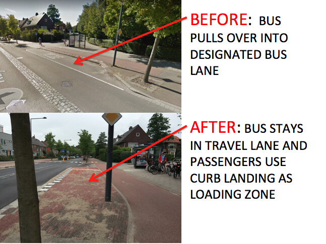
Jeff and I noticed a change in the street geometry in relation to the bus stop/lane.
BEFORE: I looked up an old image of this roadway on Google Maps Satellite and found that there was a designated bus lane for the bus stop where there is now curb (see picture).
AFTER: There is a full 8’ curb in-between the motor vehicle lane and the bike path while the bus stop seating is located in the sidewalk beyond the bike path. This makes more sense, logistically, as this street seemed to carry more cyclist traffic than it did motor vehicle traffic and the previous design would require the people using the bus to takeover the bike path as part of their loading zone. This new design offers them 8 feet of curb to use as the loading zone instead of obstructing the bike path.
ADVISORY LANE
Advisory bike lanes or “suggestion lanes” are utilized when there is a un-laned road with an average daily traffic count between 2000-5000. The Dutch came up with the application of an advisory lane by providing suggested bike lanes and travel lanes on a narrow street using dashed white lines and red asphalt. The dashed lines don’t restrict the driver of the cyclist from crossing over to another lane, but merely suggest where the cyclist should ride and the car should drive and provide room for adjustment when multiple vehicles need to pass.
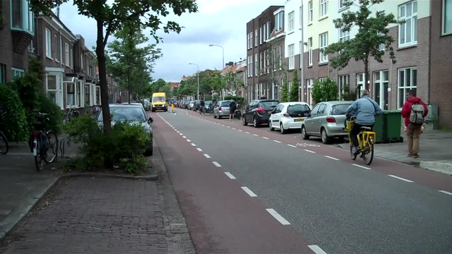
Site 6 – Hugo de Groostraat
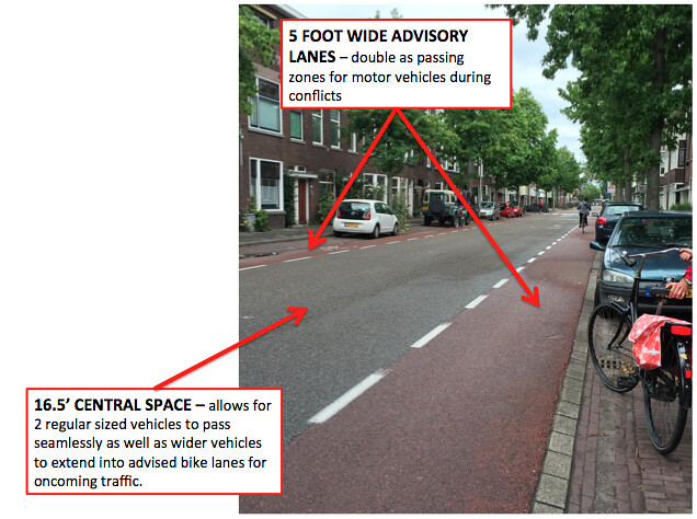
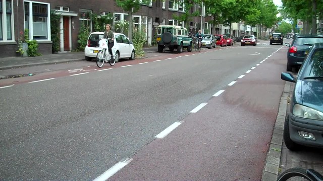
Design/Safety: This street provided a 7-foot parking lane on both sides for residential parking, a 5-foot advisory lane on both sides, and a 16.5′ two-way central space. Provided the limited right of way available, this design maximizes the use of the road for the amount of space provided. This street can comfortable fit two parked cars, two bicyclists and two regular sized motor vehicles at any given time, if necessary. The speeds of the surrounding motor vehicles appeared slow and there was a sense of community amongst the users – drivers maneuvered around bicyclists to provide more safe space and bicyclists maneuvered out of the way for oncoming 2-way traffic knowing that there was limited available space. (see video below)
Site 7 – Adriaan Pauwstraat
Historic Constraints/Design: It is very clear that there is a limited amount of right of way between the homes on Adriaan Pauwstraat. The sidewalks and parking spaces on both sides of the street need to remain, as the street is entirely residential; therefore the remaining right of way had to be reduced to advisory lanes in order to maximize the use of the available width. The advisory lanes measured out to 5 feet on each side, the central space measured 10.5 feet and the parking lanes were 7 feet on both sides. The total width of the asphalt can accommodate two regular sized vehicles and a bike, if needed, and the advisory lanes allow this to happen. (see video below)
Site 11 – Schimmelpenninck van der Oyeweg
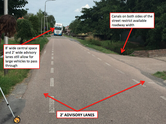
Design/Historic Constraints: The advisory lane street above is in a rural, residential neighborhood with minimal motor vehicle through traffic. Traveling along the road we passed a large number of families with their children and pets in tow while walking in the middle of the street confirming the street’s perceived safety. Advisory lanes are usually utilized when there is a limited right of way – the canals on both sides of the street (shown above) limit this street’s right of way to a total of 12 feet. The advisory lanes are both 2 feet wide on either side and the central space is 8 feet wide; this design allows for two cyclists and a regular sized motor vehicle to pass safely as well as larger vehicles to pass cyclists on one side (also shown above).
SERVICE ROAD
Service roads are another simple and cheap way to provide cyclists and pedestrians with a mixed-use low speed route to surrounding neighborhoods. In most cases, this requires a redistribution of cyclist traffic to an adjacent street with lower speeds and lower traffic volumes than the current main road. Lowering speeds is usually done by varying the roadway surface, adding speed humps, and narrowing the road.
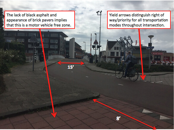
Site 12 – Zuidpoldersingel
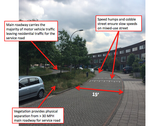
Context/Design: Not shown in the image above is an Albert Heijn off to the far left with the main roadway (left of vegetation) leading to the shopping plaza’s parking lot. Because of the shopping plaza and commercial setting, the main roadway experiences speeds over 30 MPH requiring a physically separated bike path according to Dutch design standards. At Zuidpoldersingel, a residential access road already existed; therefore the Dutch repurposed this road as a service road for all modes of transportation. They narrowed the roadway to 15 feet, resurfaced the road with brick, and added some speed humps to slow traffic to the desired local road speed. They also utilized the residential parking and existing vegetation as a horizontal barrier between the distributing roadway and the mixed-use bicycle facility.
BICYCLE HIGHWAY
A bicycle highway is usually located alongside a motor vehicle flow road as its primary purpose is to get all modes of transportation from one destination to the next in the most direct and efficient way possible.
Site 13 – N470 Bike Highway
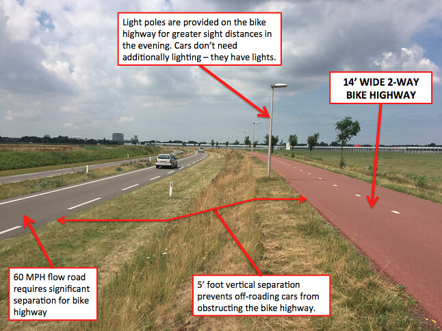
Context/Design/Safety: From the picture above you can see that both the motor vehicle roadway and the bike path have long, straight and wide facilities signifying faster speeds and efficient routes. The roadway to the left of the image is a flow road with speeds of about 60 MPH requiring a significantly separated bike facility according to Dutch standards. In this case, the bike highway is separated form motor vehicle traffic horizontally with the wide landscaped area, and vertically with 5 feet of separation from any potential off-roading motor vehicle. The bike highway itself is extremely wide at 14 feet allowing enough space for 2 cyclists to ride alongside each other in both directions as well as a meaningful amount of passing space. Additionally, I found it very cautious to include frequent light poles along the bike highway. The facility is in a rural area and is very far from any commercial or residential neighborhoods; the light poles aid bicyclists sight-lines and feeling of general safety in the evening.