
Charles Street Redesign
Stacey Bacheller, Emma Katz, Liam Morgan & Jesse Morrow

Figure 1: Section of Charles Street from Cambridge Street to Beacon Street
Charles Street is a one-way southbound street in historic Beacon Hill lined with retail space. It begins at Cambridge Street and travels south 1,776 feet until it reaches Beacon Street. Charles Street currently has three travel lanes for motor traffic, on street parking on both sides, narrow pedestrian sidewalks, and no bicycle infrastructure. While this road was historically built as a through road, it no longer needs to function as one. Roads such as Storrow Drive have since been implemented as major arterial roads with access to popular Boston locations. Charles Street has become cluttered with motor traffic as it is often used as a shortcut to get to downtown Boston and is inconsistent and incompatible with the purpose of this road – a pedestrian friendly area with minimal through traffic. With this in mind, the primary goal for the redesign of Charles Street is to improve pedestrian accessibility and comfort throughout the street as well as to provide a safe bicycle connection from the Cambridge area to downtown Boston.
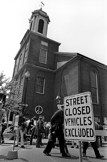
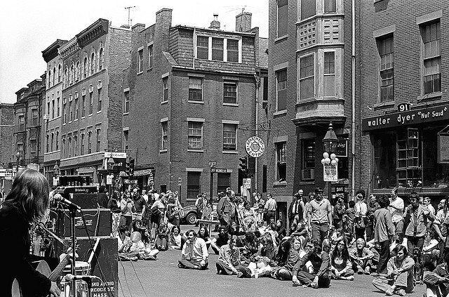
Figures 2 and 3: Historic pictures from 1970 street fair
Currently, Charles Street acts as a distributor road with cars cutting through from the Longfellow Bridge to reach downtown. Charles Street was not intended to be used for this function as shown in Figure 2 and 3 during a street fair in the 1970’s in which the street was closed to cars. Home to both residences and businesses in the historic Beacon Hill area, the street must be demoted to serve a more local function since cars accessing downtown should use Storrow Drive or Cambridge Street. If successful, the proposed design could permit weekend closed street days, just like Newbury Street in the summer and Charles Street back in 1970.
Existing Conditions
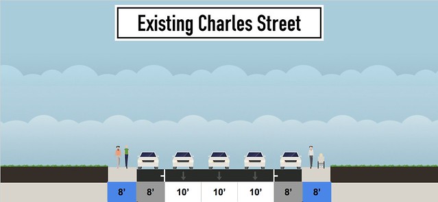
Figure 4: Current cross section of Charles Street
The current design of Charles Street is disproportionate to the usage of the street. Currently, 74% of the street is given to cars, while only 16% is allocated for pedestrians. This is not in balance with the percentage of users of this street, since the majority of restaurant and commercial shop users are pedestrians. Located in the historic neighborhood of Beacon Hill and in close proximity to many public spaces, local residents and many tourists visit this street on foot. In the redesign, sidewalks will be widened to 13 feet, increasing the percentage of pedestrian space to 42%. This percentage is in better agreement with the typical activities of this street. Widening sidewalks not only makes the street more enjoyable to hang out and walk along, but also leaves room for restaurants to add outdoor seating, benches and other street furniture.

Figure 5: Three unmarked lanes allows for speeding vehicles and unsafe crossing
It is clear that the Charles Street was originally designed as an auto-centric corridor. Allowing for through traffic on a street full of shops on both sides brings up a discongruity in the functions of the street. Most of Charles Street has three unmarked travel lanes flanked by a row of parallel street parking on both sides as shown in Figure 5. This 45 feet of asphalt is dangerous to pedestrians who merely want to enter a shop on the other side of the street, particularly in a “double-threat” situation when a passing car does not see the pedestrian that another car is stopped for. The 8-9 foot sidewalks on each side of the street communicate exactly who this public space was built for (the car) and dictate how pedestrians should be expected to get out of the way for cars.
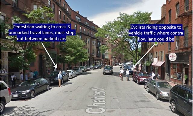
Figure 6: Existing street-view
With so much room left available to vehicles and little to no painted lines to restrict movement, drivers have little guidance. Figure 6 shows a pedestrian stepping into the street from between two parked cars and waiting for a car in the middle to pass. At the same time, a pair of cyclists are illegally travelling up a one-way street since there is no existing bicycle infrastructure.
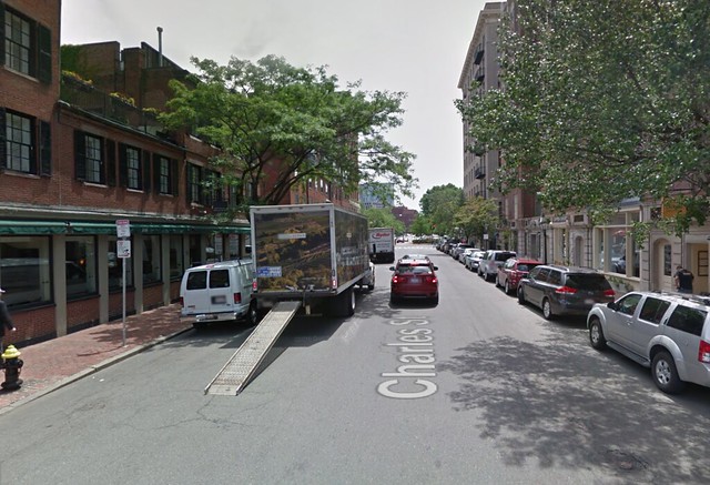
Figure 7: Delivery truck double parking
One of the complications with Charles Street are the frequent truck deliveries made to shops throughout the day which often involve double parking in the travel lanes as shown in Figure 7.
Because of double-parking, Charles Street already acts as two lanes, and sometimes even one-travel lane when double-parking occurs on both sides. Therefore, Charles Street will be able to accommodate the same amount of traffic as a one-lane street, further discussed in the redesign. When double-parking occurs, delivery trucks and cars remove space from cyclists as well as reducing driver’s visibility to crossing pedestrians. Our redesign of Charles Street takes into consideration the necessary truck deliveries close to storefronts but gives priority to making this street enjoyable for shopping and public use. Rather than allowing trucks to double park and have other users of the street bend to their will, it would be better to design for truck deliveries as an exception to the rule rather than one of the main purposes of the street.
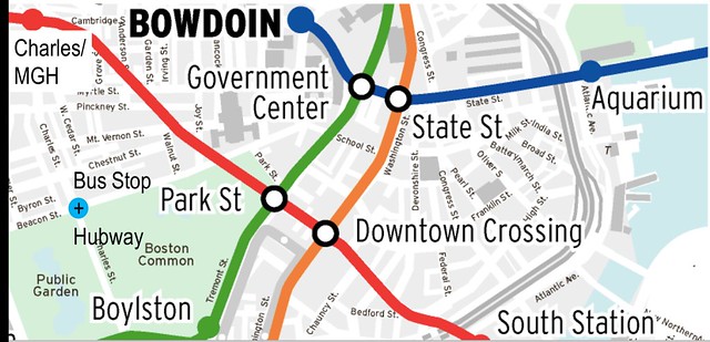
Figure 8: MBTA Map
Reducing the amount of car through traffic on Charles Street will allow for more space and usage by pedestrians and cyclists. Charles Street is very accessible by public transportation since many MBTA lines are within walking distance, as shown in Figure 8. There is a Red Line T stop on Charles Street and Mass General Hospital, and the Green Line stop at Park Street is less than a 10-minute walk from Charles Street through the Boston Common. There is also an MBTA bus stop at the intersection of Charles Street and Beacon Street and a Hubway bikeshare terminal in that vicinity. Located adjacent to the Boston Common and Public Garden, Charles Street is a natural destination for people to wander around, especially shoppers and tourists in the area. By improving the street for foot traffic and cyclists, it is our hope that more people will choose to arrive by these (anything but car) means.
Charles Street Redesign

Figure 9: Proposed Design of Charles Street
The main vision of the redesign is to create a pedestrian friendly road that reduces through traffic, improves bicycle connection, and maintains low car speeds. Ideally, Charles Street will become an attractive and accessible street for pedestrians and bikers to enjoy despite regular car traffic. Due to the number of residential and commercial buildings in the area, it’s important to maintain most of the existing parking in the area in order to please shop owners and residents. For most of the corridor where parking exists on both sides, sidewalks will be widened to 13 feet, which will improve the experience of shoppers. At the occasional areas where parking is removed, sidewalks will become even wider at 20 feet.

Figure 10: Demote Signalized Intersections and Connections to Bicycle Network
To greater improve the conditions for pedestrians and bicyclists traveling on Charles Street, the speed limit must be physically enforced through design. As shown in Figure 10, all signals along Charles Street (except for Beacon Street and Cambridge Street), will be removed. Stop signs will be implemented for traffic on cross streets, which allows for continuous through movement of vehicles on Charles Street. Taking away two lanes from traffic should have little to no impact on queuing as cars currently are essentially driving in one or two lanes of traffic because of the constant double parking that occurs on Charles Street. Continuous through movement, though great for minimal queueing, may allow for speeding on Charles Street. By reducing the amount of through lanes from three to one, cars will be unable to pass one another, which will directly lower the average speed of cars. Additionally, raised intersections are proposed so cars must slow down where a majority of pedestrians will be crossing.

Figure 11: Proposed design for the intersection at Charles Street and Beacon Street
Decreasing the number of lanes leaves just enough room to add an 8 foot two-way cycle track while still keeping parking lanes on both sides of the road for most of the street. At the Charles Street and Beacon Street intersection a left turn and right turn lane have been designed to accommodate for the traffic volume at this intersection. To allow for high volumes of pedestrian and bike activity, the bike lane will be increased from 8 feet to 10 feet order to allow groups of bikers to wait at the intersection to cross (Figure 11).
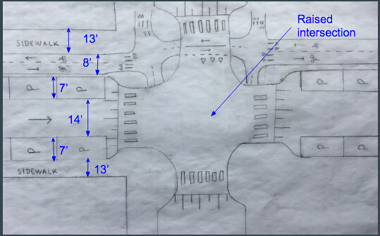
Figure 12: Typical unsignalized intersection
Figure 12 above shows the design of the proposed typical unsignalized intersection. Since the number of travel lanes will be reduced, all intersections along Charles Street will become unsignalized in order to accommodate the amount of traffic and maintain a through movement. At intersections, parking will be removed, leaving more room for an extended sidewalk. In addition, the cycle track will continue through the intersection, with cars yielding to cyclists and cyclists yielding to pedestrians. Yielding is indicated by the triangles, or “shark-teeth.” Pedestrian crossings are indicated by zebra stripes and piano keys indicate that the intersection will be a raised speed table. As mentioned before, raised table crossings will be implemented at every unsignalized intersection to prevent potential speeding near pedestrian crossings. Additionally, pedestrian crossings will be pushed back from the center of the intersection so turning vehicles from perpendicular streets will have greater visibility of pedestrians.

Figure 13: Example of extended pedestrian area in Pijnacker, South Holland
Pedestrians are the priority in the redesign of Charles Street. Sidewalks of 13 feet are an improvement from the existing 8-9 foot sidewalks, but if the street is going to truly be the pedestrian friendly corridor it’s meant to be there should be areas of wider sidewalks to accommodate more pedestrians, terraces, green spaces, and a general space for people to enjoy Charles Street. In order to maintain parking spaces, which is also important for Beacon Hill residents and some visitors, there will be occasional parking within the study area that will be removed so sidewalks can be extended. Ideally, all parking would be removed so the whole street would have wide sidewalks, but because parking is important for locals, this is a compromise that will both improve pedestrian conditions and satisfy the needs of Beacon Hill residents. Additionally, the extended sidewalk can serve as an emergency delivery option for stores if items need to be delivered outside proposed delivery times for the street. The sidewalk will be mountable to make this a viable option if necessary, otherwise it will serve as a pedestrian area such as the sidewalk on Oostlaan in Pijnacker, South Holland (Figure 13).
Parking
Despite accessibility to the area by public transportation, Beacon Hill on-street parking is highly-desirable. Therefore, the redesign maintains the maximum number of parking spaces. However, the option of removing more parking was assessed, suggesting that people who are temporarily visiting Charles Street utilize parking in local garages instead; however in the Beacon Hill area, there are only two parking garages within reasonable walking distance – the Charles Street Garage and the Boston Common Garage. The Charles Street Garage is a high-end parking garage that caters to residences and visitors but only has 43 spaces. Even if rates were made competitive to the current on street meter rates, there would not be enough capacity at this lot to accommodate for the number of parking spots preferred to be removed. The Boston Common Garage could be a potential option to justify removing some of the parking on Charles Street but rates would have to be competitive with on street meter parking as well. If residences and locals agreed to using the Boston Common Garage and losing more on street parking than proposed, the option of alternating parking on both sides of Charles Street could be implemented (Figure 16 below).

Figure 14: Rijswijkseweg with service roads that have parallel parking with intermittent trees and large walking areas

Figure 15: On street parking along Rijswijkseweg with trees and bike parking in row
An important element in our redesign of Charles Street is our utilization of the parallel parking lanes for trees, streetlights, and other sidewalk obstacles. This helps to maximize the space available in front of shops but does not neglect the important effects of greenery and good lighting along a street. Parking spaces with these short abutments are quite common in the Netherlands, as Figure 14 and 15 shows in the town of Rijswijk. While the Public Works Department in Boston might complain about the difficulty of plowing snow along the curbs, we believe that having this special condition along just 1,776 ft of road would be an acceptable solution.
https://flic.kr/p/W9spMv
Figure 16: Alternate design with one row of on street parking alternating sides
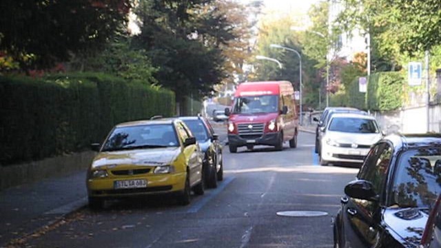
Figure 17: Parked cars create a chicane and enforce traffic calming
Multiple designs were considered in order to solve the parking issue on Charles Street. While we ultimately decided to keep parking on both sides of the street, with occasional removal for sidewalk extensions, there were a few designs that would provide more room for sidewalks and bicycle facilities while still keeping some form of on street parking. One option would be to have parking on one side of the street but alternate which side it is on (Figure 16 and 17). This would create an informal chicane that would force cars to travel slower in order to navigate through the parked cars. This design would help achieve the goal of enforcing lower speeds, however, it would eliminate most of the on street parking that is currently available.
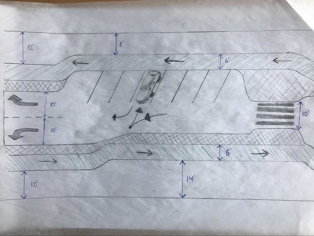
Figure 18: Alternate redesign of Charles Street with back in angled parking
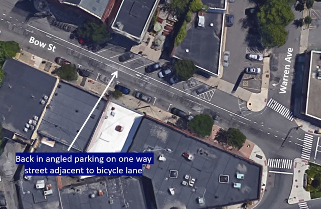
Figure 19: Back in angled parking on Bow St. in Somerville, MA
An alternative option would be to implement back in angled parking on Charles Street. This proved to be successful on Bow Street in Somerville, MA shown in Figure 19 and fits more spaces in an area than parallel parking. Cars that reverse into angled parking spots are able to pull out much faster than traditional street parking. Passengers exiting their car are funneled towards the sidewalk reducing the risk of being hit by a car. Drivers are also able to load their trunks much easier since the back of the car is up against the side walk. This option, though, requires more horizontal space than parallel parking, which may take away space from pedestrians and bicyclists.
Bus and Delivery Zones
In order to compensate for the reduced travel lanes, some parking lanes will periodically be used as a loading zone for deliveries and other large vehicles. Ideally, there will be a dialogue with the residents and shop owners in order to determine the best times during the day to prohibit parking and allow parking lanes to be used for trucks. This method allows us to keep the same amount of parking spots while still providing access for vehicles loading and unloading.
Since most parking meters in Boston are enforced from 8:00 AM to 6:00 PM, a suggested time for truck deliveries would be from 8:00-11:00 AM during the week, as most residents will be leaving their spot by 8:00 AM on weekdays. Delivery trucks can also use the extended sidewalk space provided by removal of some parking spaces in emergency situations, shown in Figure 13, the Dutch example in Pijnacker.
Boston Public Garden Connection
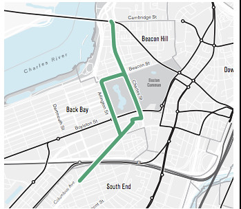
Figure 20: Proposed Go Boston 2030 bike facilities around the Boston Public Garden

Figure 21: Proposed connection from Charles Street to proposed Public Garden bike facilities
As a part of the Go Boston 2030 plan, the city of Boston has proposed potential bicycle facilities around the Boston Public Garden. This bike facility would drastically improve cyclists mobility throughout Boston since bikes are currently prohibited inside of the gardens and traveling along Beacon Street to Arlington Street is very high stress. The redesign for Charles Street would seamlessly connect bikers traveling from the Longfellow Bridge, which is currently under constructions to better accommodate bicyclists, to the Boston Public Garden. At the intersection of Beacon Street and Charles Street, a separate traffic signal will be added for bicyclists so they have a protected phase. This complete network would encourage more people to bike from the Cambridge area across the Longfellow Bridge to Downtown Boston via Charles Street.
Longfellow Bridge and Charles Esplanade Connection
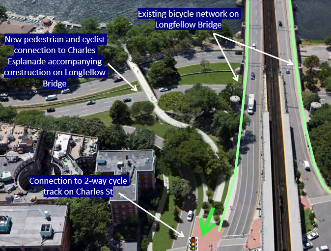
Figure 22: Bike network on Longfellow Bridge and new bridge to Charles Esplanade
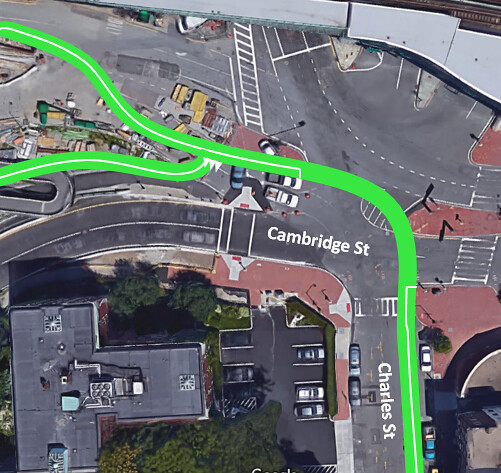
Figure 23: Proposed cycle track connection from Cambridge Street to Charles Street
At the intersection of Charles Street and Cambridge Street, it is important for our proposed design to connect well with the existing and proposed bicycle and pedestrian network. The Longfellow Bridge, after construction, will provide facilities for cyclists and walkers to easily cross the Charles River. Once construction is completed on the Longfellow Bridge, a new bicycle and pedestrian bridge to the Charles River Esplanade will also be installed, which will greatly improve access from the Beacon Hill area to the Esplanade. As cyclists approach this intersection from the Longfellow Bridge or Charles Esplanade, it is important that they can connect easily to the Charles St. two way cycle track that is on the far side of the road, or vice versa. The redesign accounts for this necessity by providing a continuation of the proposed cycle track to both the Esplanade access bridge and the Longfellow Bridge. Bicyclists will also have a protected signal at this intersection to ensure a safe turn onto either of these facilities.
Conclusion
The intention of the Charles Street redesign is to create a friendlier public space for pedestrians and cyclists. The street will be demoted from three travel lanes to one; however, at the intersection with Beacon Street, Charles Street will increase to two travel lanes to accommodate for the high traffic volumes turning onto Beacon Street. In addition, traffic signals will be removed from all intersections (excluding the intersection of Cambridge Street and Beacon Street); therefore, one-lane of travel will be sufficient since cars can continue without stopping. Another issue with the current three lanes of travel is the double-parking observed daily on this street. Because residents, commercial-users, and even delivery vehicles use the outer travel lanes for short-term parking, Charles Street acts as a one lane road already. In conjunction with the redesign, specific commercial truck delivery times and areas will be allocated.
By reducing the number of travel lanes on this street, an 8 foot two-way cycle track can be added and sidewalks can be widened to a more generous 13 feet. This will make the area more enjoyable on the human-scale, encouraging both local residents and tourists to enjoy the street. By improving the space for pedestrians and bicyclists, businesses will benefit as more people will want to spend time on the street. Similarly, businesses on Charles Street will benefit by discouraging car cut-through traffic, since cars that use this route as a shortcut are not parking and staying to enjoy the restaurants or shop at stores. In addition, the proposed cycle track connection to the Boston Public Garden, the Longfellow Bridge, and the Charles River Esplanade will make Charles Street more accessible from other parts of the Boston area.
The proposed redesign aims to promote a more suitable function for Charles Street. Despite the road’s narrow streets, lower speed limits, and many residences and businesses, too many cars use this a cut-through route. By discouraging this incompatible use, while promoting more local usage from pedestrians and cyclists, Charles Street can achieve functional harmony. The combination of removing travel lanes, adding a cycle track and widening sidewalks will benefit all users of this Beacon Hill street.
References
- CROW. “Bicycle Traffic and Motorized Traffic within Built-up Areas.” Design Manual for Bicycle Traffic, Crow, 2016, p. 110.
- “Everyday People – Charles Street Fair, Boston 1970.” Voices of East Anglia, 7 Mar. 2017, www.voicesofeastanglia.com/2012/07/everyday-people-charles-steet-fair-boston-1970.html.
- “Go Boston 2030.” Boston Transportation Department, p. 174.
- Google Maps
- National Association of City Transportation Officials. “Cycle Tracks: Two-Way.” Urban Bikeway Design Guide, 2014, p. 45.