HW4 Delft Jonathan Zoccoli
Advisory Lanes:
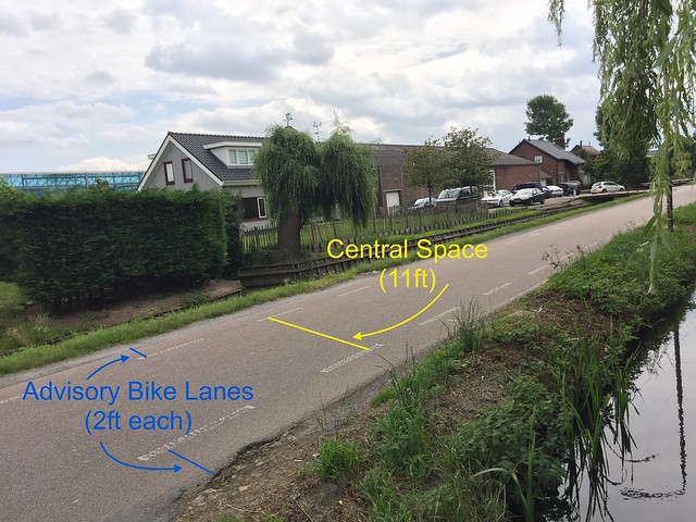
Advisory Lanes are used on roads that are too narrow for both car lanes and bike lanes. Dotted lines and red paint are used to suggest where bikes should ride for optimal safety. However, these lanes are not exclusive or separate. The dotted lines indicate that the bike lane and center area are a shared, mixed space for both cars and bikes. What this means is that regardless of dotted lines and red paint, cars may use the entire road. Cars often use part of the advisory lane as the roads are narrow, meaning that cars must go into an advisory lane on one side of the road, in order to give space to bikes on the other side. Other times, two cars will be traveling in opposite directions and must either use both advisory lanes in order to pass, or move slowly while one car passes. The small width of these roads cause cars to move slower, making this a calm, safe road that can be used by bikes without protected or separated infrastructure.
At site 6, the video below displays how an intersection of streets with advisory lanes works effectively. Bikes usually follow the suggestion and stay in the advisory lane, and leave it when there is an obstruction. Vehicles stay in the center spaces when bikes are present, but use the advisory lanes when necessary.
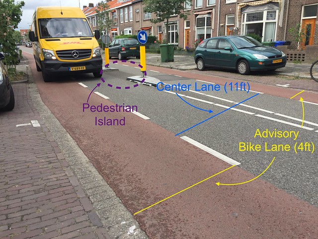
In the picture below, at Site 7a, cars and trucks can fit in the eleven foot center lane, however when approaching a pedestrian island, must use the advisory lane in order to continue on. If a bike were in the advisory lane when a vehicle was about to pass, the vehicle would move slowly behind the bike until there was room to go around. The pedestrian island offers a safe way for pedestrians to cross the street. Mixed streets like this one work well for bikes and drivers, but may be confusing and daunting to pedestrians. The pedestrian island offers a clear path for pedestrians to cross, and increases their visibility to bikes and vehicles driving through. Additionally, the street of site 7a is long and straight. To avoid high vehicle speeds, there must be curves or speed humps to slow them down. Pedestrian islands cause the road space to curve around them, essentially creating an S-curve. This requires vehicles to travel at the speed limit.
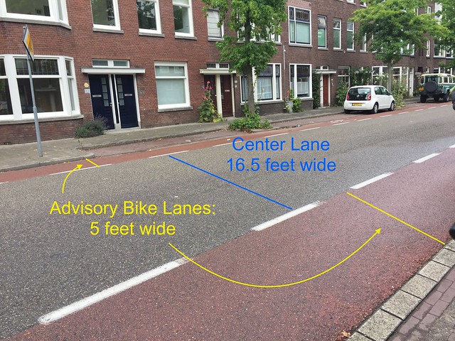
A similar situation unfolds at site 7b, just around the corner from site 7a, where the central space is wider. This means that if only one car is going down the road, it doesn’t need to use the advisory lane space, even if there are no bikes using it, unless a car traveling the opposite direction is present. In this case, bike traffic would continue to flow, one car would stop, and the other car would wait for an advisory lane to be clear of bikes. Once the lane is clear of bikes, that car would use the advisory lane to pass the stopped car and continue on, in which case the stopped car would then be able drive on, without using the advisory lane space.
On rural country roads, advisory lanes are also present. At site 11, pictured below, there is a narrow rural road with advisory lanes and a central space. Vehicles may not be expecting bikes and pedestrians on rural roads, so the dotted lines suggest the safest place for the users to be, and also indicate to vehicles that the road is not just for them, although they may use the whole space if needed. What road feature is notably missing is a centerline. Centerlines divide the road into two lanes, and squeeze out bikes and pedestrians that may be present, as they are now in the “car lane”. The centerline restricts usage of the road, and also encourages higher vehicle speeds as drivers feel they have a dedicated car lane to use. This design is safer for bikes and pedestrians, and slows down car traffic, making the road safer for cars as well.
Bike Boulevard
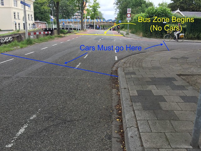
The idea behind bike boulevards is to provide bikes with a safe, quiet, and low traffic route. Bike boulevards are quiet routes for biking, made up of continuous local streets that stretch for a considerable distance. They usually have limited jogged sections, meaning there is a more direct route for bikes. Bike boulevards can be regular, low-traffic streets where cars and bikes can share the space. Features such as parking lanes, narrow pavement, road surface, and road function can create this street type. This is seen in site 5 below, where cars are not allowed on the street for one section, essentially removing the function of through road from the street. This car-free section allows buses, and has advisory lanes for bikes to indicate they are still allowed here. Where cars enter again, the lane width is narrow, and parking lanes are present. This encourages slower speeds, as drivers have less room to drive and must pay attention carefully. Additionally, the presence of parked cars indicates that doors might open at any time, and people may be crossing the street to and from their cars.
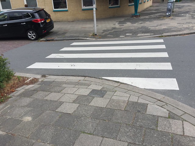
This street can not be a through road, because the function of through road is incompatible with the function of local residential street. As seen in the pictures below, the street is heavily residential after this car-free zone. The road entrance and crosswalk is only 10 feet, making entering cars move slowly. The pavement then ends, and becomes brick.
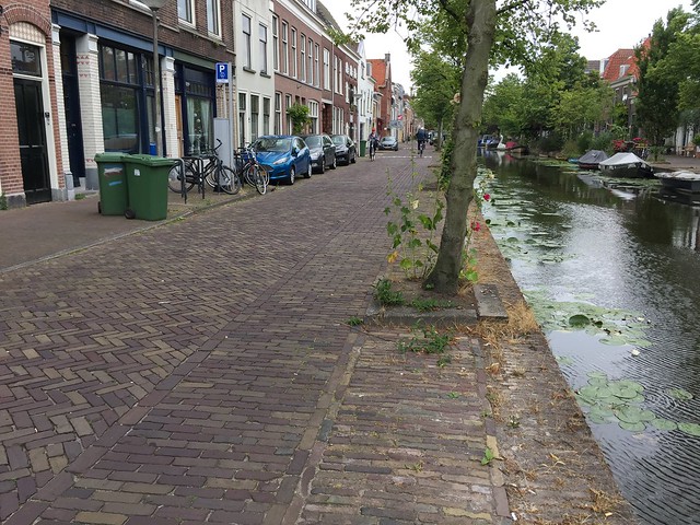
The brick street tells drivers that they are entering a residential neighborhood, and they are guests. To speed through here would be to rudely enter someone’s home. The brick street is also laid out to show a suggested path for bikes. Bikes will use the suggested path as it is more comfortable to cross bricks perpendicular to direction of travel, rather than perpendicularly. However, if an obstruction is in the suggested path, there is no issue using the rest of the road to go around it. The same goes for vehicles: they will stay in the main part of the road but can use the suggested bike path if needed. It is important to note here that the bike path is unofficial: it is merely a suggestion, and a reminder to cars that bikes are present.
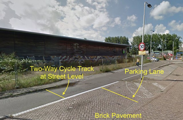
Bike boulevards can also have dedicated cycle tracks or bike lanes on a quiet, low traffic street. An example of this is in site 1, pictured below, where there is a two-way cycle track and a traffic calmed street. The street here is paved with bricks, not asphalt, again indicating to cars that they are entering a neighborhood and people’s homes. Cars can not use the cycle track, as it is protected by a parking lane. However, bikes can use the rest of the street. This creates an environment where through bike traffic has a place to ride through, while local bike traffic can meander through the rest of the street to their nearby destination.
Parkways
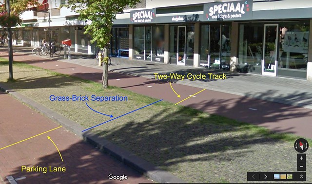
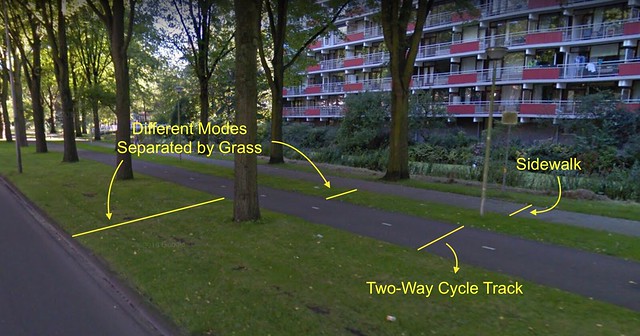
Parkways are routes for bikes that have a lot of greenery. These designs often create a parkway like experience for drivers and pedestrians as well. As seen below in site 3, each mode of traffic is separated by grass and trees.
Service Roads
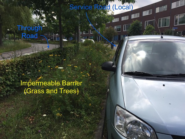
Service Roads are local, low-traffic roads parallel to high traffic routes. This design keeps through traffic from going through local, residential areas, with some permeable barriers for bikes. Some service roads are impermeable barriers to keep all through traffic from crossing into the residential areas. Without high traffic volume, the service road creates a safe environment for bikes to travel on, and makes the road safe for kids to play on. An important feature of service roads is the parking lane and green barrier. It is important that the green barrier between the high traffic road and service road also has the parking lane next to it, on the service road side. This creates a further sense of safety and separation from high traffic, while making the street seem like an extension of people’s front yards.
Bicycle Highways
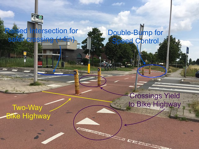
Bicycle Highways are two way cycle tracks that follow their own right of way. They provide a bicycle connection where a car connection isn’t possible, and can often be more direct than the car connection. Intersections with roads and paths are limited, but when they come up the priority is given to bikes in order to maintain uninterrupted, direct connections for bikes. This is seen in site 13 below, where the bike highway surface is kept level, why the cars and pedestrians must walk up to the level of the bikes. This tells bikes, in addition to signage, that the bikes have priority here, and that the cars and pedestrians must yield to the bikes.
Cycle Tracks
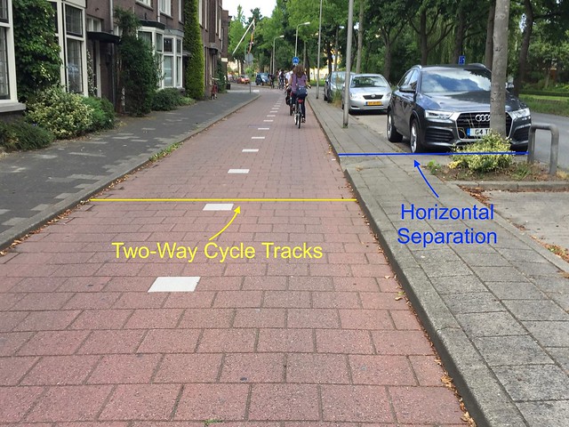
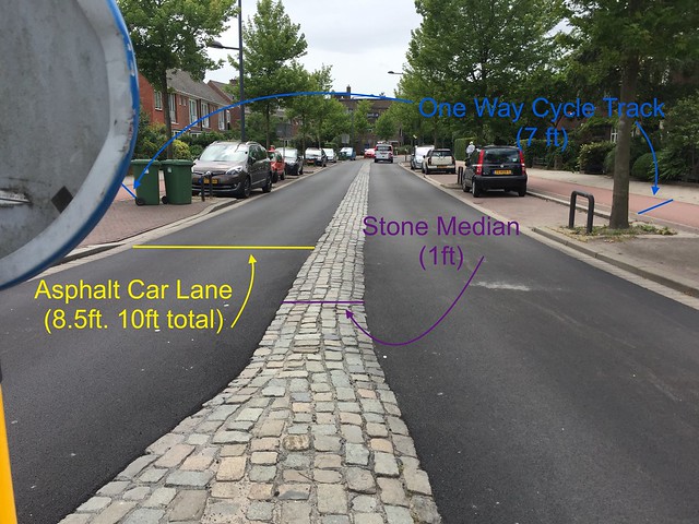
Cycle Tracks are paths for bikes to ride on that are protected and separated from vehicle traffic. There are two kinds of separation: vertical and horizontal. Many cycle tracks use some variation of both. At Site 8, we see one-way cycle tracks on each side of the street. They are raised 4 inches above the vehicle lanes, in addition to being 7 feet away from these lanes. The 7 feet are used as parking lanes and trees, and the vehicle lanes themselves are 10 feet wide. The 10 foot lanes only have 8.5 feet of asphalt, with a rain gutter and median made of stone, comprising the remains 1.5 feet of lane. What this achieves is slower speeds. Vehicles can use the stone areas if they need to, and it won’t damage the cars. Drivers want the smoothest ride possible, and thus will go slow to stay on the 8.5 foot asphalt space.
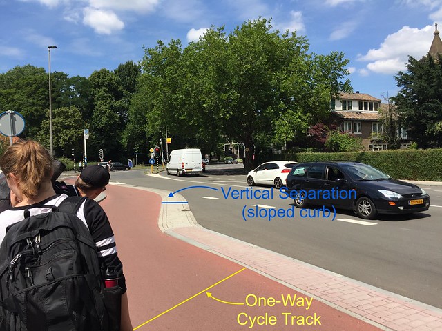
Site 10 features another one way cycle track, this time with different separation tactics from the lane. There is 1.5 feet of horizontal space from traffic. Vertically speaking, the pavers used slope up 4 inches above the car lane. This means that bikes and cars are closer together, yet still separated. Although this may seem more stressful, it is still safe. Bikes become more visible to drivers in this setting and will be more mindful of their driving relative to the bikes, which could result in slower speeds.
One-Way cycle tracks work because they give a safe, protected, dedicated space for cyclists, without the worry of a head-on bike collision when passing a slower rider. However, sometimes the usage of one-way cycle tracks means that you have to go one way down an entire block before making a U-turn to go the opposite way. One-way cycle tracks can make it difficult to access commercial areas, as to go back to a shop, you might have to do a whole loop of the block instead of just going the opposite way of the one-way cycle track. Two way cycle tracks solve these problems, as you can go in two directions on the path and not have to go out of your way just to go left down your street instead of right. Two-way tracks allow shoppers to go any direction they wish to access shops. This is seen below at sites 9 and 2.