
HW4 Delft Stacey Bacheller
Bike Lanes: Separated from car traffic only by paint. In the Netherlands, bikes lanes are appropriate for 1+1 lanes with no parking; however, bikes lanes do exist along parking with low turnover rates.
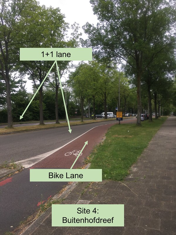
This 5.5 foot bike lane on this street works well since Buitenhofdreef is a low traffic distribution road intended to connect local roads to the main flow roads. Since each direction of traffic is separated by a median, bicyclists are only worried about motor traffic at intersections. Despite sometimes having cars parked on the outside of the bike lane, the bike lane does not need to be a cycle track in this case since there is not very much traffic and the cars are traveling at low speeds.
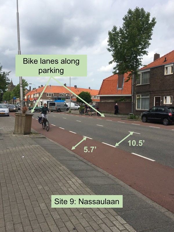
This bike lane attempts to provide sufficient room for the bicyclist alongside parking; however, a cycle track would be preferred in this situation. Despite providing an extra 1.7 feet to the standard 4 feet for the bike lane, the two-way traffic does not provide a calm, comfortable environment for the cyclists. In addition, the main purpose of this road is local; however, the intersection nearby connecting this street to Julianalaan is quite busy.
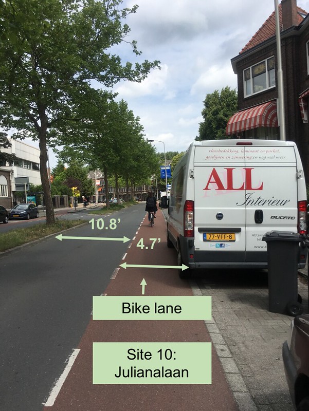
As opposed to Site #9, the motor traffic in each direction is physically separated by a median and the road is 10.8 feet, forcing cars to drive slowly. Unfortunately, the van is larger than the parking space provided, so some of the 4.7 foot bike lane is blocked, forcing the cyclist to ride closer to the road. A cycle track may not be necessary here since the speed is low and most traffic is local.
Bike Boulevards: “Quietways” or Neighborhood greenways, good for bikes, but not cars.
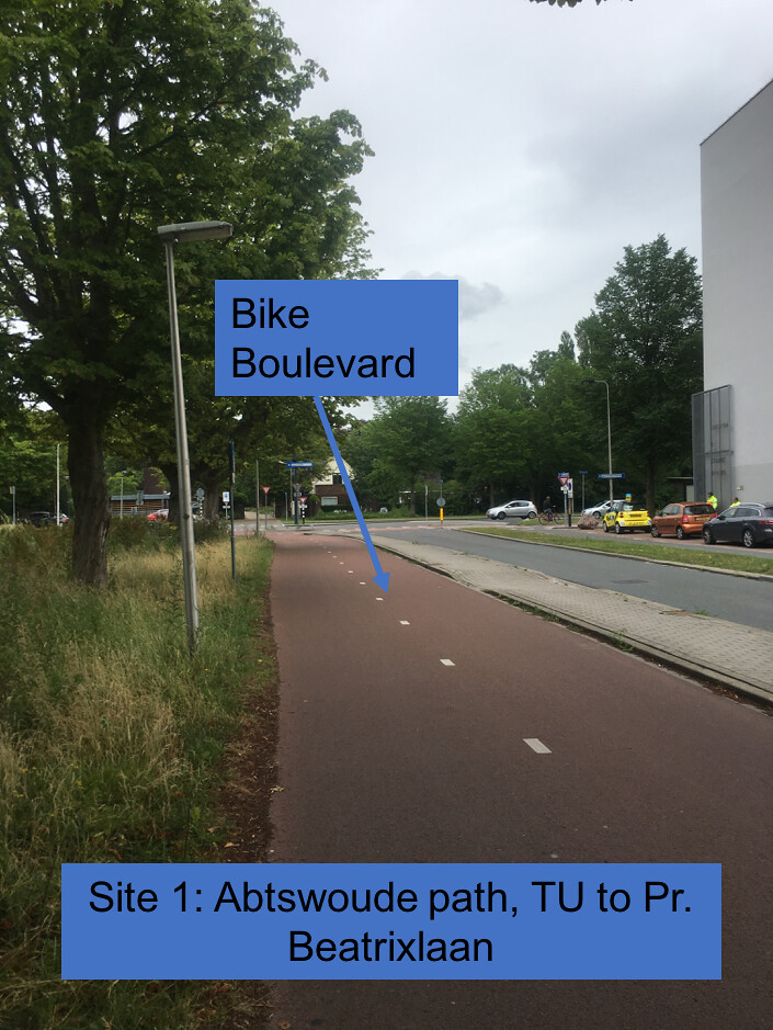
This bike boulevard is very convenient to get to and from the University of Delft. This site serves bicyclists best; therefore, during peak times such as before class start times traffic officers are present to help cars get through. The boulevard is quite wide allowing for both two-way traffic as well as riding side by side. As a long, separated path it is very safe from a bicyclist perspective since cyclists do not need to pay attention to motor vehicles as they travel along the local streets, path, tunnel and bridge.
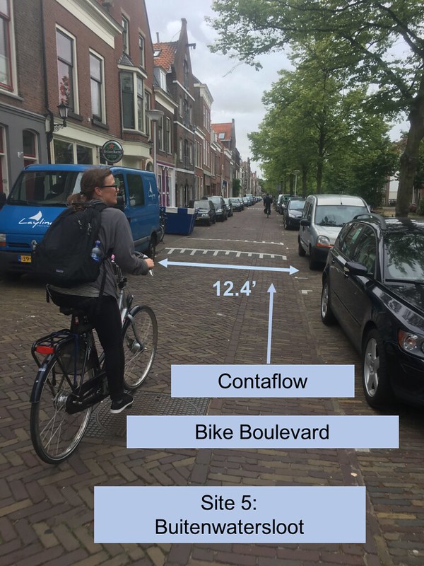
This bike boulevard is located on a local street alongside a canal. It is a diversion from a historic road. Since its purpose is to serve local traffic most cars traveling on this road are traveling slow and for only a few short blocks. The contraflow on this one-direction road is necessary since it is convenient, direct route to travel. In addition, the slow traveling speeds make the contraflow bike boulevard comfortable and low stress.
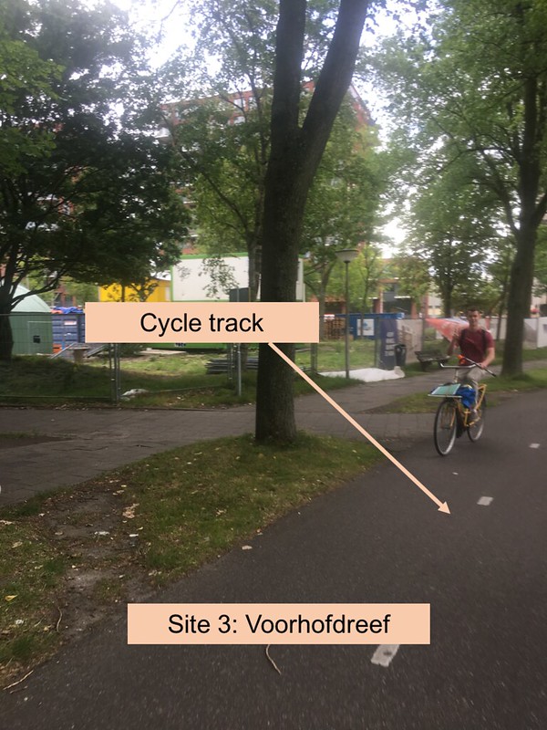
Cycle Tracks: Physically separated path for cycling. Cycle tracks are preferred over bike lanes since they are generally safer and provide a low-stress environment since cyclists are not directly next to motor traffic.
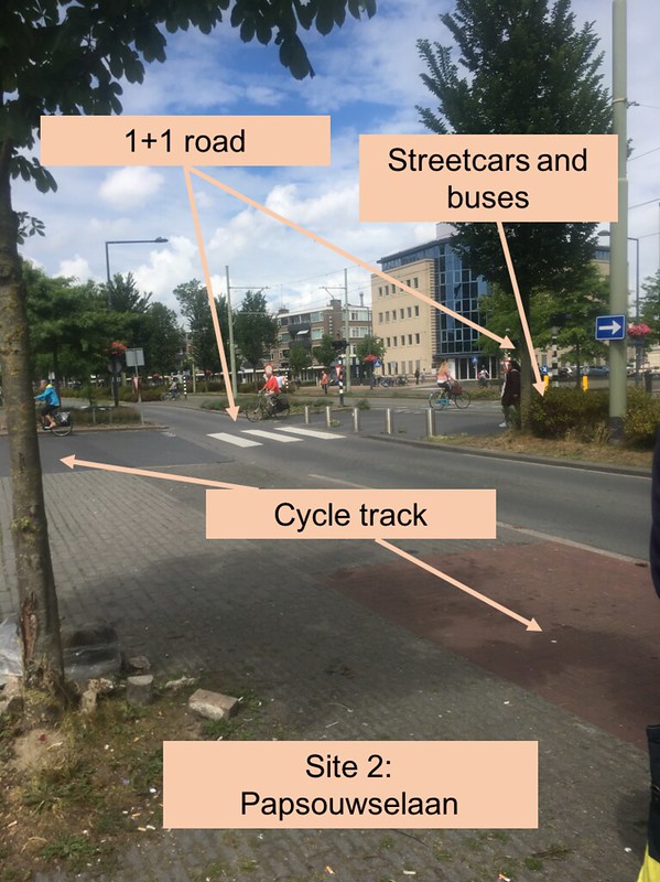
This street experienced a road diet when it was converted from a 2+2 mixed function road to a 1+1 road. The streetcars and buses in the center are separated by a permeable barrier and cycle tracks are located along the outside. The width of the street for cars is a narrow 9.6 feet or 10.4 feet measured curb to curb, which forces traffic to be slow. Another interesting aspect of this site is who takes priority. This site encourages that trams take priority over pedestrians, pedestrians over cars, and bicycles must yield to cars.
This two-way cycle track is located alongside a 2+2 parkway, or open landscaped highway. Motor traffic is traveling at higher speeds; therefore, it is necessary for the bicycles to be physically separated. In addition, because the cycle track allows for both directions, cyclists do not have to cross the parkway. This allows for a comfortable, safe and low-stress experience while traveling on the bicycle.
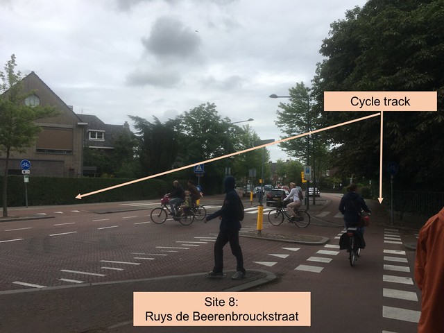
At this intersection, motor traffic transitions from 1+1 lanes with no parking to 1+1 lanes with parking on both sides. There are cycle tracks located on the outside, but inside of the pedestrian side walk. This site is interesting because of its dual purpose as both a local and distribution road. It is a local road since it hosts a supermarket, houses, and a school nearby. It is also an essential distribution road to travel East and West. Because of the conflicting purposes, what should the speed limit be? Locals want the street to be safe for children and crossing; however, motor traffic want to reach their destination quicker. To appease both parties, the road’s speed limit is 50km/h (standard for distribution) with no traffic lights (previously was 2); however, the seemingly narrow street self-enforces a lower speed of approximately 40 km/h. Despite having no traffic light at the intersection, crossing is made easier by creating waiting areas for pedestrians so they only have to cross one lane at a time. In addition, the change from black asphalt to red, stamped asphalt and a slight, attention grabbing height change makes cars more aware of the intersection and encourages safer behavior.
Advisory Lanes: “Suggestion Lanes” where bicycles and cars share the road. They are generally too narrow to add full size bike lanes.
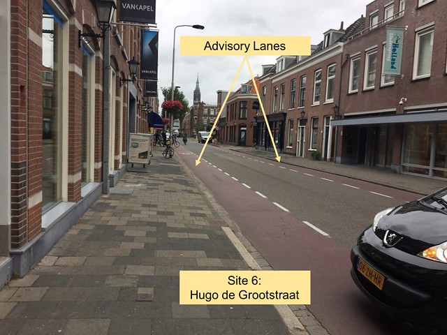
Although it is not shown in this picture, this road has parking alongside the advisory bike lanes. However, since the street consists of local traffic, the motor speeds are low. In addition, both the travel lane and the advisory lanes are quite wide and could almost be wide enough to create full bike lanes.
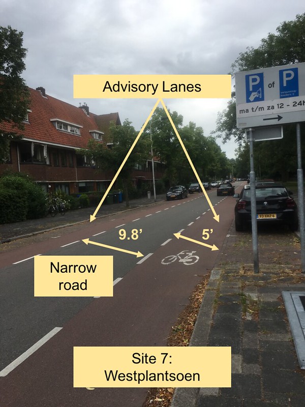
At this site, advisory bicycle lanes work well because of the road’s purpose to serve local traffic. The lane for the bicycles is wide enough to provide a one-foot buffer from the parked cars. Also, the cars are small and parked far enough to the right providing even more room for the cyclists. The two-way direction of this street does not impose any risks to the cyclists since the cars will be traveling slowly and can move over and use the necessary available space provided by the advisory bike lanes.
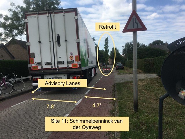
On this rural, local road, cars are transitioning from a 60 km/h zone to a 30 km/h zone; therefore, a narrow pinch point was retrofitted to the street in order to force traffic to slow down by maneuvering around the tree. The turn enforces the speed limit, yet is easy enough to maneuver around as shown by the large truck in the image. The travel lane and advisory lanes are even smaller than in an urban environment since the amount of traffic is significantly lower.
Service Road: “Parallel Roads” where no cycle track is needed since there is such low traffic and slow speeds.
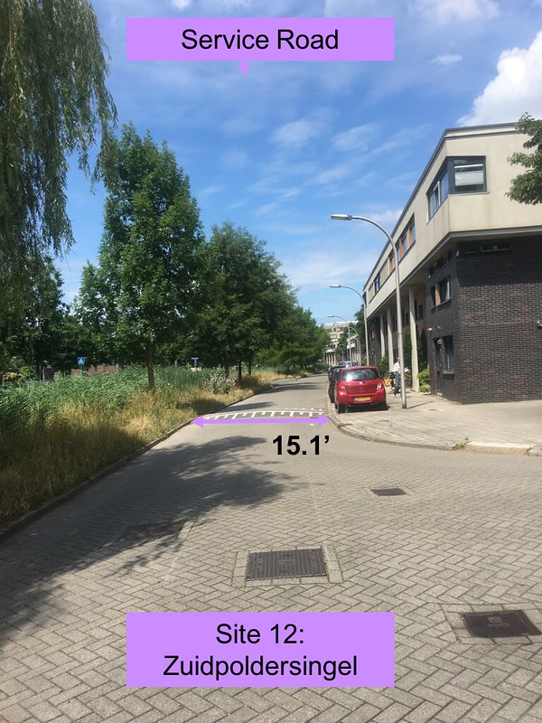
On this wide “parallel road,” or service road, bicyclists and cars share the road. Cars traveling on this road are about to park or turn to their destination; therefore, they are traveling slow and for only a block or two. They are not in a rush and should not mind traveling behind a bicyclist for such a short distance. However, when a bicycle goes to cross the main travel road, the cars have the right of way and the bicyclist must yield until the appropriate time. The service road differs from a bicycle boulevard since it is directly next to the main through road; therefore, cars are not forced to use the service road, they are only on the road to reach their desired destination.
Bicycle Highway: Similar to a car highway, a highway for bicycles allows for traveling long distances with limited or no stops.
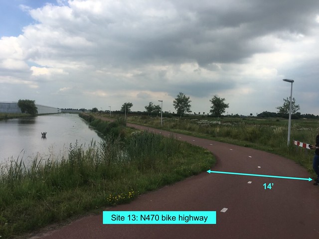
This site is inside the “Green Heart” of The Netherlands. The bicycle highway is very wide allowing for side-by-side cycling, as well as passing. The scenery is beautiful allowing for a calm, low stress bicycle travel. The high speed motorway is located alongside the bike highway; however, there is a sufficient distance and height separating the two so there is no danger imposed by cars. Similar to a highway for cars, the bicycle highway is well lit for long travel from city-to-city.