
Delft Bicycling Facilities
In most areas of the United States, travel via bicycle is often left for weekend getaways or sport cycling. However, in the Netherlands, the bicycle is seen as a valuable method of getting from point A to point B. On average, the Dutch take 0.78 bike trips per person per day. This number stems from the bicycle infrastructure built within the country. The Dutch infrastructure makes bicycle riding both safe and desirable. As a student studying in Delft, I had the opportunity to tour 13 locations which showcase bike facilities found in the Netherlands. The bike facilities studied were bike lanes, bike boulevards, cycle tracks, advisory lanes, service roads, and bicycle highways.
Bicycle Lanes
The bike lane is the most familiar Dutch facility to American eyes. It consists of a bike lane immediately next to the lane(s) for motor traffic. A line acts as a visual barrier to separate the bike lane from motor traffic. During my tour, the bike lanes felt the most dangerous of any of the facilities due to the close proximity to vehicles. To address this safety issue, the bike lane is used as solution for low speed roads with no parking and one lane of travel in each direction. Slower moving traffic means that motor vehicles have more control when passing bikes and even if a collision were to happen, the probability of a serious injury is much less than it would be with fast moving traffic. No parking on streets with bike lanes allows cyclists to only worry about the moving traffic to their left, and not car doors being opened to their right. Additionally, I noticed that driveway entrances are sparse on bike laned roads so that motor vehicles do not have to cross the bike lane frequently. While riding around Delft, I was able to visit three bike lanes: Martinus Nijhoflaan (Figure 1), Nassaulaan (Figure 2), and Julianalaan (Figure 3).
Figure 1: Martinus Nijhoflaan
Martinus Njhoflaan was by far the most stressful facility visited on this tour. Similar to American designs for bike lanes, the road next to the lane was not that slow moving. Thus, even though I had my own lane, my perceived safety was lowest at this location. However, a major improvement over American designs occurred at intersections. The bike lane continues through intersections to still give cyclists their space rather than disappearing and leaving cyclists lost at a point of conflict.
Figure 2: Nassaulaan
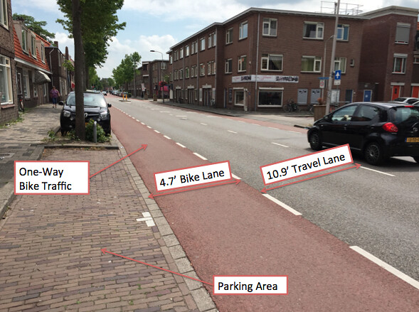
Nassaulaan is a local road providing residential access, so the motor traffic is generally traveling at a slow rate. An interesting technique the Dutch use to force motor traffic to go slow is to provide narrow lane widths, as shown above. Cars on Nassaulaan are less likely to speed than on a similar road with 13 foot lanes. The concern with this road, however, is that parking is provided. This increases the risk for a cyclist to be “doored” by drivers exiting their parked vehicle.
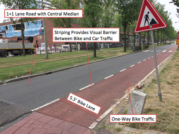
Figure 3: Julianalaan
Julianalaan is a 1+1 lane arterial that serves bus routes and a residential community in Delft. Parking lines both sides of the street, and so do bike lanes. The desired reach for a bike lane is about 14.5 feet, but Julianalaan only provides a 12.2 foot reach. Because of these tight quarters within the bike lane, cyclists have to worry about both the motor vehicle threat on their left and the “dooring” threat on their right.
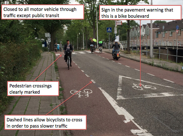
Bicycle Boulevards
Bike boulevards (quietways) are entire roadways dedicated to cyclists. The Dutch use bike boulevards as low cost solutions for heavy bike traffic since they can be old roads that are no longer used as main through roads. If the road is only partially closed to vehicle traffic, speed control methods may be necessary. During the trip, I had the opportunity to visit two bike boulevards: Abtswoude Path (Figure 4) and Buitenwatersloot (Figure 5). The rides were very pleasant and relaxing. There was hardly any noise for the amount of people using the roads, and since there was no motor traffic to rush my cycling, I was able to ride as slow as I wanted to enjoy the views of the local scenery. In both locations, I felt that I had more than enough space to maneuver my bike, which gave me enhanced perceived safety.
Figure 4: Abtswoude Path
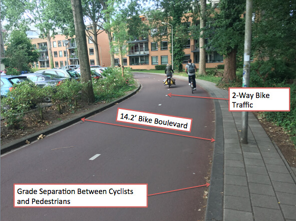
The Abtswoude Path connects the campus of TU Delft to Pr. Beatrixlaan, a major through road. Thus, it must carry heavy amounts of traffic since hundreds of students and faculty often travel this route at one time. The path is wide enough to accommodate a large number of bikes in both directions, and is separated so that users can relax on their way to work or school. While riding this route, it was hard to believe that I was in the middle of a city since the trees masked most of the sights and noise.
Figure 5: Buitenwatersloot
Buitenwatersloot used to be a main 2-way road in the city of Delft. After a new through route was built, it was demoted to a bike boulevard by first installing a permeable barrier and then implementing a fine system for cars. Thus, it is as wide as a two-way road for cars, but it is used primarily for bikes. Instead of closing the road completely, the Dutch created a wonderful through route for bike traffic.
Cycle Tracks
The main feature of cycle tracks is that they are separated from motor traffic by a protective barrier. This barrier could be parked cars (the cheapest solution), parkways, or a good deal of vertical/horizontal distance. Cycle tracks can also be one-way or two-way facilities. The Dutch use cycle tracks in higher speed roads, or roads with heavy vehicular traffic. Compared to other bike facilities, cycle tracks are generally more expensive. However, what they lose in cost they gain in safety. Being completely separate from motor traffic is the main reason for this. Even through the roundabout at Papsouwselaan, the cycle track still felt safe since bikes had the unquestionable right of way over cars. I was able to ride three cycle tracks while riding around Delft: Papsouwselaan (Figure 6), Voorhofdreef (Figure 7), and Ruys de Beerenbrouckstraat (Figure 8). During these rides, I felt entirely safe and my peers seemed to favor these facilities the most.
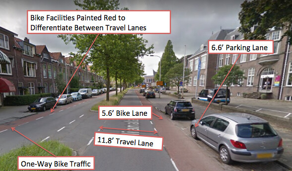
Figure 6: Papsouwselaan
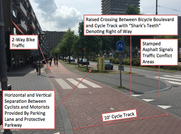
Papsouwselaan serves multiple shops, bus routes, tram routes, and a high number of motor vehicles. Due to this high traffic, the Dutch separated the cycle facility and made a two lane cycle track on both sides of the road. However, this high traffic does not mean that this road has four lanes. Contrary to American thinking, the Dutch converted this road from two lanes in each direction to one lane in each direction in order to improve safety. The road still flows as efficiently as it once did even with the smaller road width. They did this by taking the outside travel lanes and converting them to parkways and parking lanes. Further down the street, a roundabout had many interesting features to protect bicycles. These included raised crossings to alert drivers that they were in a bike area, shark’s teeth to let drivers know that bikes have priority through the roundabout, and waiting areas so that a driver could focus on crossing the cycle track before worrying about merging into motor traffic.
Figure 7: Voorhofdreef
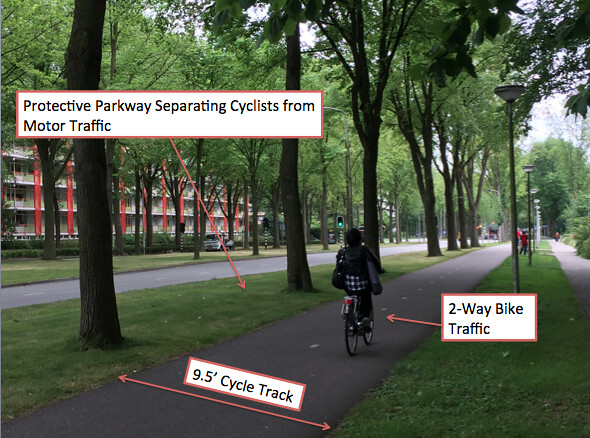
The cycle track at Voorhofdreef was separated from the motor traffic using a large parkway with trees as protection. This allowed for the better safety of cyclists while making the area look beautiful. The width of this track allows cyclists to ride side by side with a friend and enjoy the scenery. While two-way cycle tracks like these are nice in spot areas, connecting them back to one-way cycle facilities creates some problems. One lane will often have to turn off onto a side street or be dropped altogether. However, the added capacity and the luxury of two-way cycle tracks make them a wonderful bike facility.
Figure 8: Ruys de Beerenbrouckstraat
Ruys de Beerenbrouckstraat is a 1+1 lane road that serves a shopping center, residences, and bus routes. Thus, it also needs separated cycle tracks to keep cyclists safe from the heavy traffic. The barrier used in this case is cheap, since it is provided by the citizens of Delft themselves, parked cars. Of the three cycle tracks visited, Ruys de Beerenbrouckstraat was the only one with one-way cycle tracks. This is not as luxurious since the cycle lanes are narrower, but it works with the space constraint provided. Another downfall of one-way cycle tracks is that riders sometimes go the wrong way, which can create tight quarters between the passing traffic.
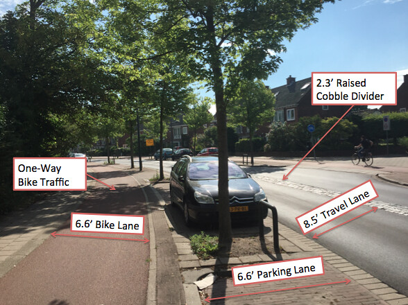
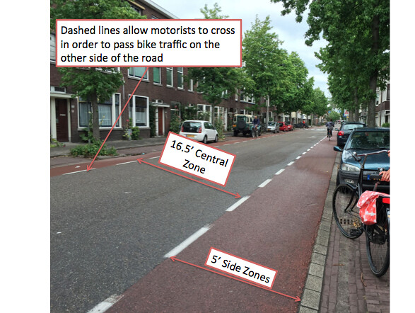
Advisory Lanes
Advisory Bike Lanes are roads with a central unmarked zone and two side zones painted a certain color (the Dutch use red). Advisory lanes work by allowing both bikes and cars travel as they normally would, bikes sticking to the right and cars traveling down the middle. When passing needs to happen, the cars are permitted to cross the dashed lines and enter the side zones. This could be to pass a bike on one side of the road or to pass an oncoming vehicle. The colored lane signifies to a driver that it is likely a bike will be found in that area and that they should be cautious while moving around other traffic. Advisory lanes can provide one-way or two-way vehicle traffic, and can have central zones less than five feet wide. The Dutch use advisory lanes where there is low motor vehicle traffic (2000-5000 cars per day). During the ride, I had the opportunity to visit three advisory lane locations: Hugo de Grootstraat (Figure 9), Adriaan Pauwstraat Westplantsoen (Figure 10), and Schimmelpennick van der Oyeweg (Figure 11). Riding on these roads was very easy and felt safe. Obviously, advisory lanes would not work on high volume roads, but on low volume roads they felt just as safe as cycle tracks. One argument that I have heard against advisory lanes in the U.S. is that people would have a difficult time understanding them. After riding through these locations, the movements of both motorists and cyclists occur easily and naturally. People do not want to get into an accident, so they will avoid each other.
Figure 9: Hugo de Grootstraat
Hugo de Grootstraat is a two-way road located in a residential area of Delft. Therefore, people use this road for access to their houses and to small community buildings. Parking is also available to residents of the community. An interesting aspect of this street is that cars can park facing opposite of the direction of travel. This did not seem to reduce safety or as I rode through the area.
Figure 10: Adriaan Pauwstraat Westplantsoen
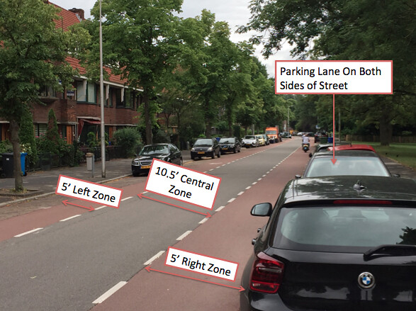
Adriaan Pauwstraat Westplantsoen is also located in a residential area of Delft, meaning it will have to serve the same function as Hugo de Grootstraat. Adriaan Pauwstraat Westplantsoen has a narrow center zone, but is still able to handle two-way traffic. If two cars meet, they both will have to move partly into the side zones. On a low volume road like this, that is not a problem.
Figure 11: Schimmelpennick van der Oyeweg

Schimmelpennick van der Oyeweg is a two-way road located in a rural area just outside of Delft. It serves as a connection between a residential area and rural houses and businesses, as well as a commuting route into the city. Its central zone is very narrow, which will force cars to almost always ride partly in one of the side zones. This helps with speed control though, since drivers will try to remain in the zone as much as possible. Another speed control aspect of this road is the retrofitted planter that forces drivers to yield and curve around it. Reducing speeds on advisory lanes forces the cars to travel at a closer speed to the bikes using the road, which makes the design safer.
Service Roads
Service Roads are residential access roads parallel to main roads. They can be traveled by motor vehicles at low speeds in order to get to a destination, but they are not for through traffic. Speed control devices like speed humps and permeable barriers are often used to make the route only desirable for the cars that need to be there. Having a wide open road free of fast-moving motor vehicles allows for a direct route for bikes. I was able to visit one service road on the outskirts of Delft: Zuidpoldersingel (Figure 12). This ride felt very safe, especially considering I had a 15 foot lane to myself for all but two seconds when a car needed 8 feet of it.
Figure 12: Zuidpoldersingel
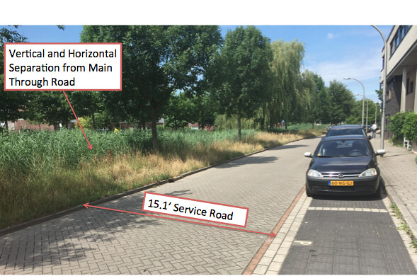
The service road at Zuidpoldersingel gives bikes a nice, wide road where they can travel parallel to the road with fast moving traffic. Exits are provided at intersections to allow the bikes to get out of the service road and continue on to their destination. If cars need to travel the service road, the road is wide enough to accommodate both car and bike. Parking is also provided for those that have business in the buildings next to the service road.
Bicycle Highways
Similar to cycle tracks, bike highways are completely separated from the road and motor traffic. Bike highways are their own separate facility with few conflicts and rare stops. They allow for bike travel to occur at high speeds for long distances. Highway-like exits allow cyclists to leave the bike highway when they wish. I was able to ride along the N470 Bike Highway (Figure 13).
Figure 13: N470 Bike Highway
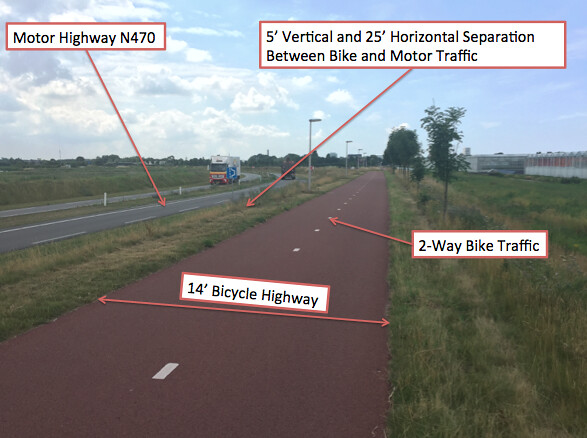
On the N470 Bike Highway in a rural outskirt of Delft, high speeds are permitted by using wide bike lanes in each direction. Additionally, the separation from the motor vehicle highway adds to both perceived and actual safety of the cyclist. I felt very comfortable riding this route and was able to ride fast (passing people on the left) or ride slow and enjoy the scenery (sticking to the right to allow people to pass me).