
Bicycle Highway from Delft to Rotterdam
By Kevin Carr
Overview
The bicycle highway I rode connects Delft to Southwest Rotterdam, running along the Delftse Schie and Delfshavensche Schie for the duration of the journey, and finishing at the Southern side of the Nieuwe Maas River (via an underground bicycle tunnel). The route is primarily a combination of separated bike highway paths and cycle tracks, with a few short stretches of advisory lanes and mixed-use roads through small villages. Travelling mostly through the countryside along the main waterway, the route is peaceful with little bike or car traffic. Closer to Delft and approaching the center of Rotterdam, the route is busier, but cycle traffic is nonetheless kept separate from car traffic whenever possible. Cyclist crossings are kept to a minimum, given priority wherever possible in rural areas, and signalized when necessary in the denser, urban stretch of Rotterdam. Overall, the ride was relatively smooth, continuous, and easy to follow, all of which are key design features of a good bicycle highway route.
Description of Route
An interactive map of the complete bike highway route taken can be found above. Key points are marked along the path where a change in cycling infrastructure was observed. The path is divided into 9 total segments (some very short), based on the type of infrastructure. Please click on any point along the route for a brief description with related images that were taken during the ride.
The route begins on Rotterdamseweg near the TU Delft campus, with a long stretch of two-way cycle track that begins close to the street and transitions into a vertically separated track with an abundance of trees and greenery (see Segment A). Car traffic is very low, and the large green buffers add a feeling of complete separation from any car that passes by. Lamp posts are encountered frequently along this stretch (about 100 ft apart), providing good lighting for cyclists at night (Figure 1).
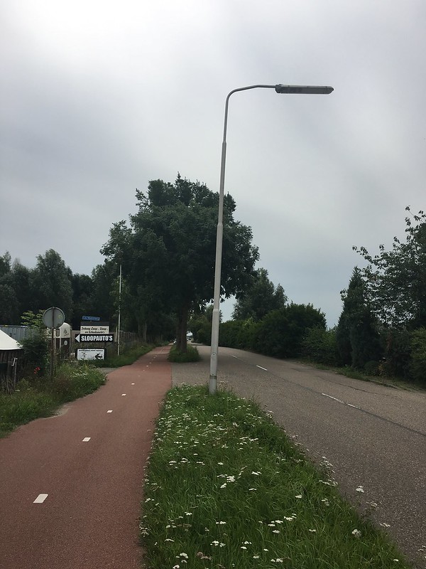
Figure 1 – Frequent lighting along Rotterdamseweg
Entering the village of Zweth, the cycle track ends, and you begin riding on a shared-use road with cars (see Segment B). At first, this was a bit annoying, as I was enjoying the peaceful, uninterrupted travel along the separated bike highway. However, I soon realized that car traffic was almost nonexistent along this stretch. Brick treatments change along the local street and traffic calming measures are put in place to ensure that vehicles are well aware of cut-through cyclists like myself. The planter boxes with arrows, for example, create an obstruction for cars and give the illusion of a narrower road, lowering speeds (Figure 2).
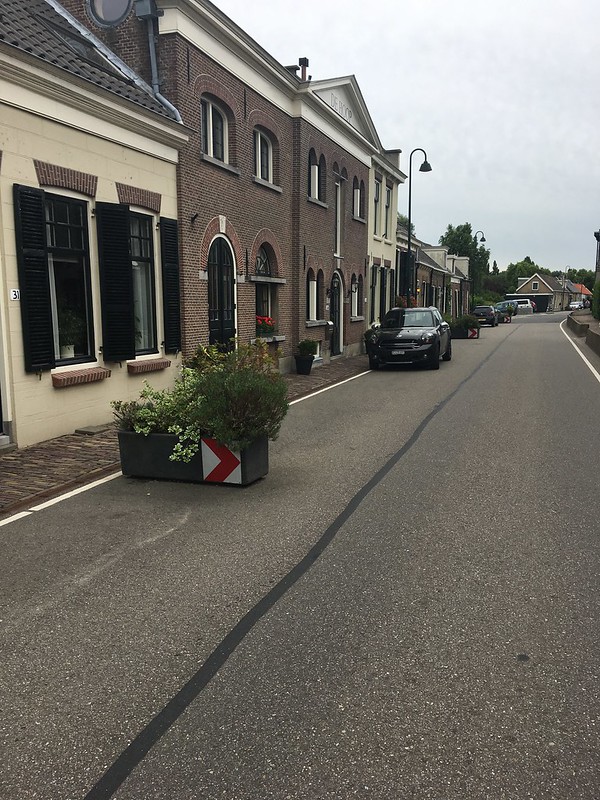
Figure 2 – Planter boxes as traffic calming device
These measures, along with the very short riding distance (only about 0.25 miles to cut through the village), were designed to minimize the inconvenience of long-distance cyclists crossing through this populated area. After leaving Zweth, the road transitions into advisory lanes for a short duration (Segment C), then transitions seamlessly back to a separated cycle track (Segment D). Cyclists cross the street here to join up with the two-way cycle track on the left side. There is a narrow cycle crossing (unraised, cyclists yield) (Figure 3), which is probably not even necessary since car traffic is so low along this stretch. (I stood in the road for a few minutes taking pictures, with no cars in sight).
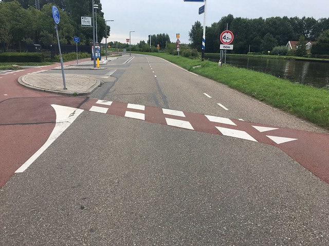
Figure 3 – Transition from advisory lanes back to cycle track
After proceeding along a pleasant stretch of cycle track next to open green fields, the cycle track transitions back to advisory lanes for a stretch of about 0.75 miles (Segment E). This stretch of route is not ideal, but red stamped pavement in the center travel zone combined with smooth asphalt on the advisory lanes communicates to cars that this is a bicycle route. Again, car traffic is light and travels slowly. One surprise I encountered was a parked car in the advisory lane, which caused me to swerve out of the way (Figure 4). Parking for residents may not be adequate along this stretch, forcing people to park illegally. However, this was the only interruption I experienced during this stretch of travel.
Figure 4 – Car parked in advisory lane
Segment E also serves as a transition region before entering the village of Overschie, at which point the advisory lanes disappear and the road becomes mixed-use. Cycling through the village was a bit inconvenient due to the winding roads and bumpy pavement, but car traffic was virtually nonexistent. With the exception of a passing bus that was almost too large for the street (Figure 5), the ride was eerily quiet. Again, the burden of cutting through a town on a shared car/bike road was mitigated by the lack of cars, short travel distance, and peaceful surroundings.
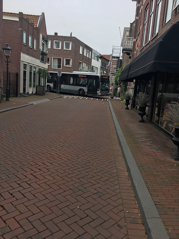
Figure 5 – An unexpected encounter in Overschie
The route takes an interesting left turn down a bumpy brick side street at the outskirts of the village, and conveniently joins up again with the bike highway (Segment G), this time completely isolated from the street and inaccessible by car. This was a clever way of joining the segments together, and gives cyclists a sigh of relief as they get back on the smooth, straight pavement. This stretch of the route includes several underpasses, keeping cyclists completely isolated from fast-travelling vehicles above. The underpass tunnels are all very short, and lighting is frequent enough to provide comfort for cyclists passing through at night (Figure 6).
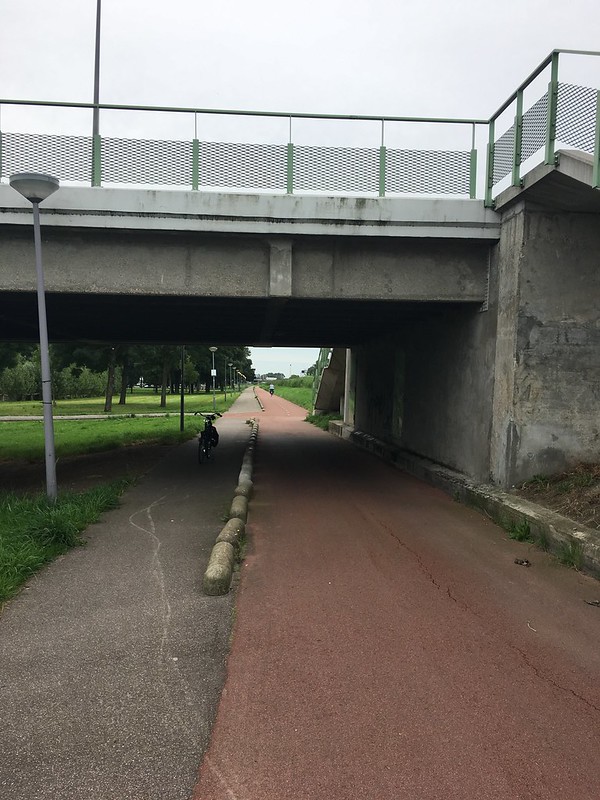
Figure 6 – Underpass with lighting
The route continues over a footbridge, signifying another transition into urban Rotterdam (Segment H). The two-way cycle track continues seamlessly across the bridge and along the canal, with a beautiful wide sidewalk and trees planted in series (Figure 7). Although you feel a difference along this stretch from the increased car traffic and noise, the cycle track is designed as a peaceful refuge, and my attention was on the sidewalk and canal as opposed to the road for most of my ride.
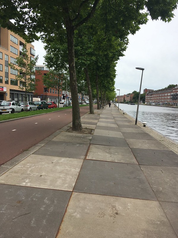
Figure 7 – Cycle track along canal in Rotterdam
The first real interruptions in the route occur farther along this stretch, where cyclists must finally cross the street at a handful of signalized intersections approaching the center of Rotterdam. Cyclists are given a dedicated traffic signal, or course, to minimize wait times as much as possible at these intersections. I was truly impressed how long I could bike on this route before encountering any stoplights. By hugging the canal around the periphery of Rotterdam, the route is designed for continuity and beauty, avoiding as many intersections as possible, even in the busy city.
The route concludes by passing under the Nieuwe Maas River in a bicycle tunnel (Segment I). Finding this tunnel took quite awhile, but the connection is ingenious. Cyclists enter through a large elevator (Figure 8) and are transported underground to a smooth, straight, fast bike path. After crossing the tunnel, a second elevator brings you back up to ground level on the other side of the river, providing an easy connection to the south side of Rotterdam. Pedestrians may also cross the tunnel on a designated pedestrian level.
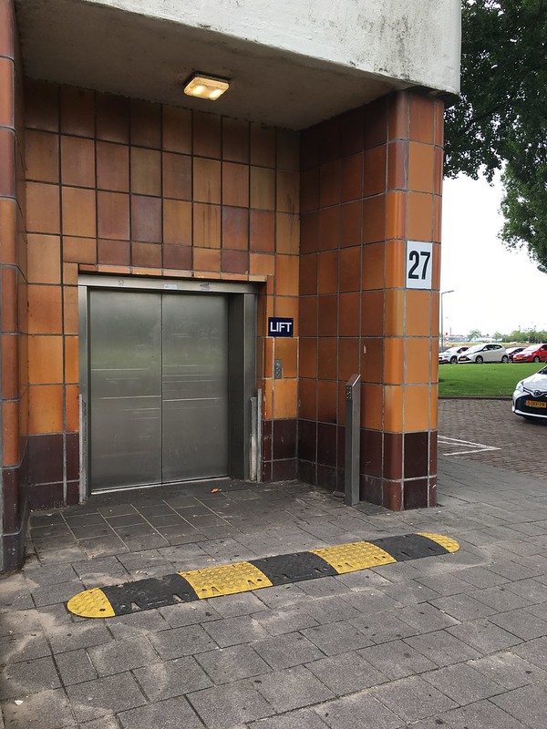
Figure 8 – Elevator to access bike tunnel
Route Statistics
A breakdown of the statistics for this bike highway route are presented below:
- Total length: 14.5 km (9 mi)
- Total number of stoplights: 4
- Total number of stop or yield points (unsignalized): 3
- Total number of overpasses/underpasses: 8
- Total number of roundabouts: 0
- Percentage of smooth, fast surface: 90% (approx.)
- Percentage of stand-alone path: 25% (approx.)
- Percentage of cycle track: 60% (approx.)
- Percentage of on-street cycling: 15% (approx.)
- Percentage of path with lighting: 95-100%
Wayfinding
With very few turns or confusing intersections, the route was very easy to navigate overall. The only junction which disoriented me was between Segments A and B approaching Zweth. The cycle track ends abruptly and feeds out onto the road, with another side street off to the left. I was concerned of making the wrong turn here, but the wayfinding sign shown below (Figure 9) makes it very clear to continue straight ahead to Rotterdam. An arrow to Delft points in the opposite direction, which confirmed I was on the correct route. Also at this intersection was a green “fietsnetwerk” sign (Figure 10), indicating the continuation of the bicycle route through Zweth towards Rotterdam. This provided more reassurance that I was on track.
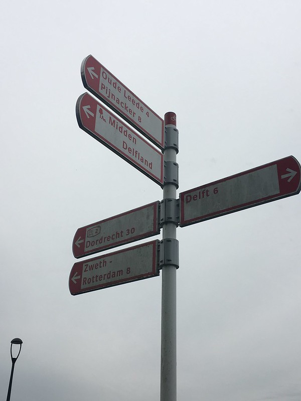
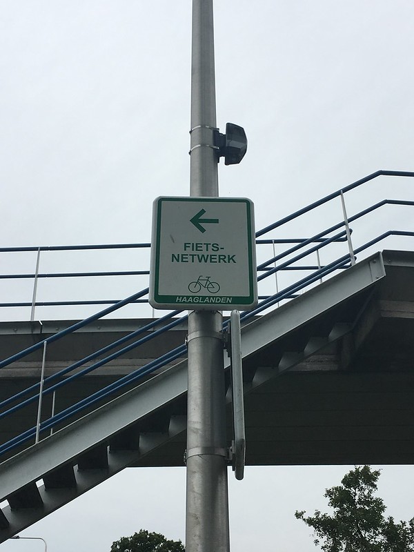
Figure 9 & 10 – Continuing to Rotterdam…
Something Extra
The vast majority of this route took me through beautiful countryside, and I saw lots of livestock grazing on the open green fields. This sheep was so close to the cycle track that I got off my bike and took a second to enjoy (Figure 11). On the way back, I also spotted a horseback rider meandering along the cycle track (Figure 12).
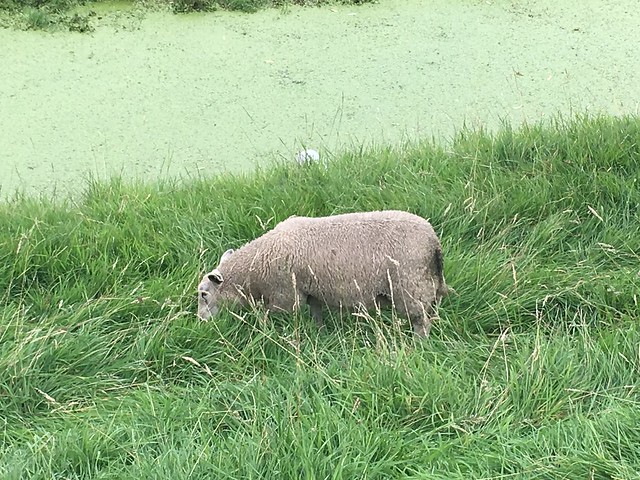
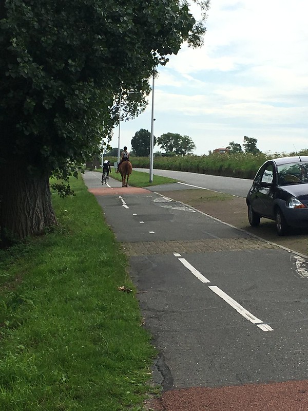
Figure 11 & 12 – Animals everywhere
Conclusion
Bike highways are designed in the Netherlands to provide convenient, peaceful, uninterrupted routes for long-distance travel between two destinations. The bike highway route from Delft to Rotterdam, while not entirely continuous or uninterrupted, accomplishes these goals on the whole. Where the route must cut through a town (such as Overschie) or a barrier (such as the canal), measures are taken to make the transition as seamless and non-disruptive as possible for cyclists. This bike highway exhibits many changes in environment, providing a great example of how different types of bike infrastructure can be utilized effectively to create an integrated, connected route.