
Because cycling is an encouraged form of transit in the Netherlands, Dutch planners and engineers attempt to make cyclists feel as safe as possible in any traffic environment without diminishing the usefulness of any other transit mode. This usually involves either controlling the motor vehicle capacity of a particular roadway or guiding the behavior of the drivers on that roadway, so that cyclists do not experience dangerous conflicts with traffic or become overcome by the stress of this perceived danger while riding. In order to produce these safe biking conditions, the roadway must be physically altered to either create adequate separation between cars and bikes or to lower driving speed to a point such that people can drive cars alongside bikes. Such physical alterations can be grouped into categories of bike facilities, which vary immensely based on a road’s historical context, a city’s regional planning strategies, and any physical boundary already present at the site.
During the first week of our stay in Delft, we focused on the types of bicycle facilities available to Dutch cyclists as well as the necessary conditions for each to be implemented successfully. We visited twelve sites in Delft and Delfgauw which had any one of six bicycle facilities, and studied their function by both observing traffic and riding in it. This page seeks to discuss each facility type individually and in-depth, in an attempt to understand their strengths and weaknesses, as well as to gain a deeper understanding of Dutch traffic engineering methodology.
Bike Lanes
A bike lane refers to a dedicated lane for bicycles which is not vertically separated by car traffic. Such a lane is usually implemented by striping a painted line to separate bicycle and car traffic, but could include additional safety measures such as painting the entire area of a bike lane (typically red in the Netherlands and bright green in American East Coast cities), striping a buffer zone on either side of a bike lane, or by constructing protected intersections.
A striped bike lane is regarded as the bear minimum requirement in terms of bike facilities in an urban setting. As the restriping of a road alone does not require any curb adjustments, it can be an attractive option to a city beginning to experiment with bike facilities, but can also be sufficient in its own right, if its design is effective at making cycling safe and is in harmony with the site environment.
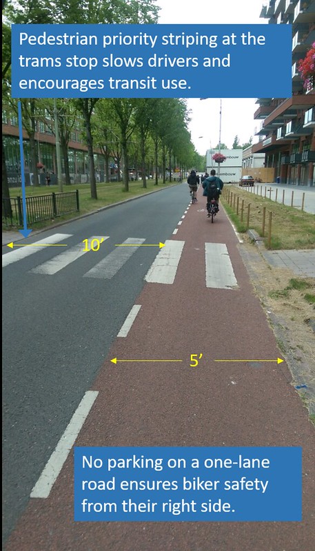
In our study of bicycle facilities in and around Delft, we visited the area near the intersection of Buitenhofdreef and Martinus Nijhoflaan, which run parallel to the 1 tram for part of their course. These streets are in the southwest portion of Delft, in the outlying neighborhoods of Buitenhof and Tanthof, and the streets themselves are situated in corridors that are not built up. They are part of network of arterial roads which connect southern Delft to the highway N470, and intersect with very few roads. With the tram in the center of the street, the street’s configuration is that of a limited access road with lanes separated by direction. There is one lane of car travel in each direction, and a five foot bike lane striped alongside both of them. This is an ideal setup for bike lanes because the one lane of travel in each direction, with the exception of turn lanes which appear at intersections, prevents passing and speeding. Additionally, no cars are parked on either of these streets, ensuring that a cyclist in either direction can feel safe with the space allotted to them.
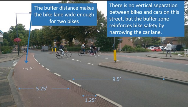
In the neighborhood just west of central Delft, we studied the streets Westplantsoen and Adriaan Pauwstraat, which meet at Buitenwatersloot on a bridge. Pictured below is this intersection, where buffered bike lanes give the bike lane added width while giving the car lane a perceived narrowness, which slows down car traffic to an acceptable level.
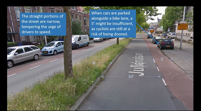
Another area that we visited that featured bike lanes was the intersection of Nassaulaan and Julianalaan, just north of TU Delft. Julianalaan is an urban arterial, which begins near a canal at the southern end of Delft Centrum and carries traffic through the TU campus. Since Julianalaan is laid out between two major points of activity in Delft, it does carry some through traffic. However, it is flanked on both sides by a number of dorms, academic buildings, and small shops, making it a principal street for short neighborhood-oriented trips. Through most of its course, Julianalaan is divided by a median and carries one lane of car traffic on either side, with parking on both sides. The frequent turns in the road and the fact that one-lane traffic will make passing impossible ensures calm traffic even on a thoroughfare, which in turn makes this a worthy site for a painted bike lane.
The bike lanes on Julianalaan are of adequate width when they are not adjacent to parking, but unfortunately there is intermittent parking on both sides of this street. Ideally, there should be three feet of separation between a biker’s shoulder and a parked car, to prevent dooring of cyclists, but this is not guaranteed with a 5′ bike lane, assuming that cyclists travel in the center of their lane. If a car is passing them on the left, they might travel slightly closer to the parked car. This reservation aside, this is a well-designed bike lane for a minor urban arterial.
Intersecting Julianalaan is Nassaulaan, which connects the TU Delft area to the N473 highway, which in turn carries traffic to Pijnacker. Because of where it is in the city, Nassaulaan does inevitably serve the function of a collector road, while also featuring some local destinations and carrying a bus route. The main difference in design between Julianalaan and Nassaulaan comes from their difference in width, as the latter also has one-way traffic with bike lanes and occasional parking on both sides, but does not have the space for a median. This accommodates any number of left turns that could be made on the local side streets, and could make drivers stay closer to the center line rather than closer to the bike lane, as they won’t be compensating for the physical barrier that a median would present in the center of the street.
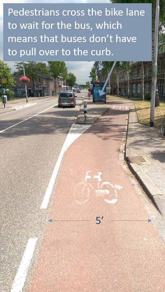
The bus stops on Nassaulaan conform to the recent change in preference of Dutch planners, in that the bus stop island is between the travel lane and the bike lane, so that the bus driver does not have to pull up to the curb when approaching the stop. Pulling up to the curb requires additional time and effort after the bus leaves the stop, especially if traffic is heavy on that road and leave space for a bus to re-enter the right of way. This prioritizes public transit on the road while eliminating conflict between the bus lane and the bike lane. If buses don’t pull over to the right when they stop, cyclists no longer have to stress about watching for them.
Cycle Tracks
While bike lanes can be made effectively to keep cyclists safe on roads with low to moderate traffic, any prioritization of through traffic on the road should see cyclists completely physically separated from cars. Cycle tracks ensure more effective separation, either through periodic barriers such as trees, bollards, lighting, or parking, or by vertical separation, whereby cyclists ride on a paved area which is higher than the car lane. This vertical offset of a cycle track can be at grade with the adjacent sidewalk, and it is common to see cycle tracks distinguished from the sidewalk only by a difference in tile or brick color. It can also be at an intermediate height, usually at least 4″ higher than the road and then an inch or two below the sidewalk. This substantial separation between cars and bikes eliminates the cyclist’s stress in constantly watching for passing cars if traffic is fast enough, or if passing is commonplace on that road. Additionally, while signals for bikes can often be found where there are bike lanes, they will almost always be found where there are cycle tracks, ensuring that bikes cross car traffic safely.
Presently, the official Dutch design recommendation is that painted bike lanes be placed on roads with 1+1 car traffic and no parking, and that any road with heavier traffic should have cycle tracks. While there are Dutch roads which have not been updated in a few decades and still have holdover bike lanes in streets with 2 + 2 traffic or with 1+1 traffic and parking, these are decreasing in number, and cycle tracks have become the standard bicycle facility on Dutch streets.
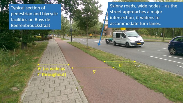
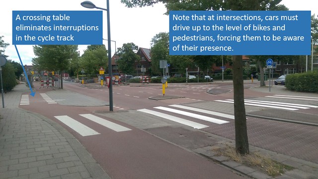
One of the cycle tracks that we visited in Delft was on Ruys de Beerenbrouckstraat, which is a major east-west collector to the North of Delft Centrum, which carries traffic between the city center and the highway Princess Beatrixlaan. Despite this function as a collector road, the street is also heavily residential, and is used for short trips, is heavily walked on, and features a bus route. Despite the Dutch guidance that urban streets either had to be 20, 30 or 50 kilometers per hour, this street was designed for 40 kilometer per hour traffic through the use of traffic calming tools.
Despite the fact that this street carries substantial through traffic, it is only a one lane road, with several turns, raised crosswalks, and pedestrian islands. At major intersections, this design conforms to the “skinny roads, wide nodes” principle, by adding turn lanes close to intersections, but keeping a one-lane width at all other points. This feature allows for maximum throughput by not letting the queue at intersections slow down traffic, but keeps the road slow and safe for all other users. Cycle tracks are separated by an area 6′ wide throughout, which contains grass trees, and intermittent parking. There are also several crossing tables, or raised intersections at minor cross streets where pedestrians and cyclists have priority over cars, and thus there is no discontinuity for bikers riding through them. The pictures below detail the cross section of the street, excluding the travel lane, as well as an example of a crossing table.
The streets Voorhofdreef and Papsouwselaan, situated not far from the Delft South Station, also feature cycle tracks. These are both wide roads (on average, these roads extended 150′ sidewalk to sidewalk) that meet at nearly a 180 degree angle at a roundabout that carries car, bicycle, pedestrian, tram, and bus traffic.
The roundabout itself is a major node in the neighborhood, which connects the two streets mentioned above with the urban arterial Martinus Nijhofflaan. The roundabout has one lane of car traffic surrounded by a cycle track, and through the center of the circle is a tram and bus rapid transit corridor. While this roundabout design is not formally part of either of these sites, it joins them in a particularly unique way, as the concentric cycle track allows for approaching car drivers to only make one major decision at a time as they approach the roundabout. In addition, the cycle track is not quite concentric, but somewhat angular, so that cyclists can see oncoming car traffic in advance of approaching the intersection.
Voorhofdreef is a 2 x 2 parkway which extends south from the roundabout towards the highway N470, for which it is a feeder road. The road is on a straight path, and it only intersects three roads between the highway and the roundabout (which is a distance of approximately half a mile), allowing for moderately fast, uninterrupted car travel. Because of the nature of this road, a cycle track is the ideal bicycle facility to complete it. Because of the immense width available on this street, there are 9′ two-way cycle tracks on each side of the car lanes, and 5 to 6 foot wide strips of grass and tall trees planted on either side of the bike lanes. This provides a parkway effect for the cars on the road and an insular canopy effect for the cyclists, making this a very pleasant route despite the street’s width. Also, as with other cycle tracks in Delft, cyclists have priority going through the minor intersections on this cycle track, and raised crossings allow for a cyclist to potentially ride that entire stretch of road without stopping.

Papsouwselaan is set up in a similar way to Voorhofdreef, in that each direction of car travel is separated, and that there is a cycle track on either side of the car lanes. However, the way that space is allocated on this street is rather unique: The car space amounts to two one-way lanes separated by the right-of-way used by the 1 tram, which is also used as a bus rapid transit corridor. This street moves traffic up to central Delft, making it a vital connection for all modes of transportation, and there are no signalized intersections along the corridor (with the exception of occasional turn lanes for cars crossing the tram tracks). There are some businesses along this street, making this a route with the potential for some short trips, but the cycling experience is similar in quality to that of Papsowselaan, with priority at intersections, raised crossings, and a straight path devoid of conflict with motor vehicles.
Bicycle Boulevard
A bicycle boulevard, also termed a Quietway, is a direct, usually crosstown bike route that takes advantage of any number of traffic calming and bike infrastructure tools in order to only be appealing to cyclists. These roads are usually not exclusive to cyclists, but end up being most heavily used by that mode of transit, especially when the Quietway runs parallel to an appealing car through route. Generally, bicycle boulevards work best in low traffic areas, in which a through route for bicycles can easily be constructed, and on which car traffic can be kept to a minimum.
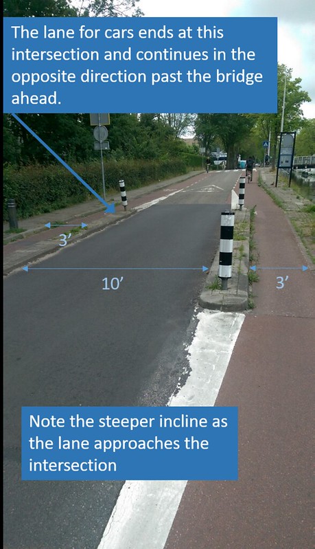
We visited Buitenwatersloot, which connects central Delft to the nearby city of Den Hoorn, but is not a principal artery. The road is primarily residential, and is situated along a canal. This road, in fact, used to be a highway, but was demoted in recent years in order to more effectively function as a local road, and to remove an unnecessary highway from the downtown area.
For cars, the road has been made one-way on each side of the canal, and bikes are capable of two-way travel on both sides because of pairs of bike lanes which have been installed on each side. There is also a section of road where one-way traffic for cars meets one-way traffic in the opposite direction, making it impossible for a car to travel the length of the entire street and ensuring that cars use different east-west through roads. The design varies somewhat, to the point where there are sections of this street with no striping at all, but the narrowness of the road and occasional speed dampening elements ensure a safe and direct route for cyclists travelling eastbound or westbound.
As the street and canal approach the center city area, the streets narrow and are only navigable on foot or by bicycle, which allows for the continuity of bicycle travel as one approaches Delft station.
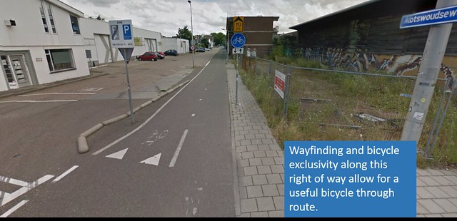
Another bike boulevard that we visited was the Abtswoulde path, which connects TU Delft to the southwestern part of the city, near the highway Princess Beatrixlaan. The route is a collection of dedicated cycling paths with a few short segments of mixed traffic in primarily residential streets. The exclusive bike paths appear to take advantage of a disused industrial road, and provide a nearly uninterrupted path for cyclists moving from one neighborhood to another. The two-lane bike path along this route appears to be about 9 to 10 feet wide, providing the width necessary for bidirectional bicycle traffic.
Advisory Lanes
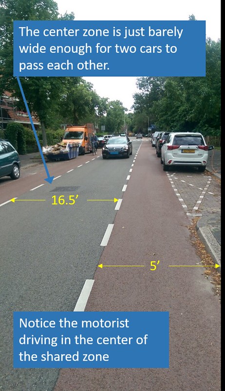
Advisory lanes are a type of bike facility which have yet to catch on in the United States, but can be particularly useful in local streets up to a certain desired speed limit and up to a certain width. Advisory lanes consist of a pair of dashed bike lane lines on a street with no center line or any other similar striping. This is especially useful in a road that is just wide enough for two cars to pass each other in opposite directions, but perhaps not wide enough for two cars and two bikes to all pass the same point at the same time. Because of this, a residential street with limited parking and relatively low traffic would be ideal. Another constraint for this tool is that there should be few traffic lights at intersections, so that cars do not form long queues for turns, disrupting traffic flow in the opposite direction.
We visited Hugo de Grootstraat, which is a residential street extending from one of the peripheral canals of Delft Centrum to Princess Beatrixlaan. We observed traffic there, and paid particular attention to how cars and bicyclists negotiated taking up space in the road. In this street layout, cars are the primary users of the road, and cyclists are guests, meaning that it is totally acceptable for cars to use part of the advisory bike lane if they need to pass another vehicle. By the same token, a car can drive in the center of the street if they do not see any cars ahead, because there is no striping dividing the road.
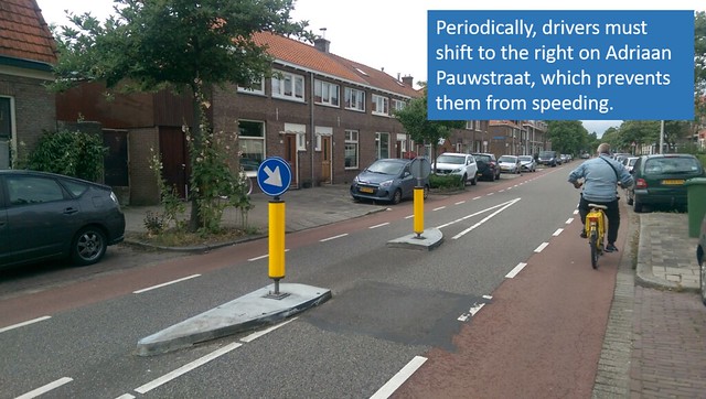
We visited this street along with the neighboring streets Adriaan Pauwstraat and Westplantsoen, which are similar residential streets that have advisory lanes with the same dimensions. It is worth noting that the traffic calming elements in the design of these streets is very spaced out, but effective in their aim. There are infrequent raised crossings, but toward the middle of any of these streets, there are posts in the center of the street, forcing any driver to shift to the right and preventing them from speeding.
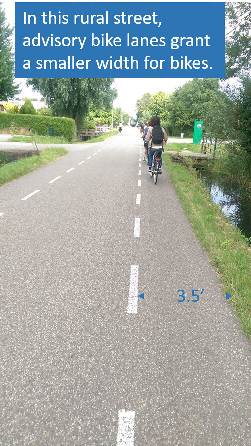
This type of design can also be successful in a less urban setting. In Delfgauw, a neighboring suburb of Delft, we visited a neighborhood with several winding, short streets which prominently featured advisory bike lanes that mirrored those in Delft. The street which stood out in this area was Schimmelpenninck van der Oyeweg, which was a long, straight, rural road which terminated in this small residential neighborhood. It contains advisory lanes in the urban style up to a point, but eventually they transition into narrower lanes which share a color with the center zone. The road itself was surrounded by industrial farming and greenhouses, so it appeared to serve mainly as an access road for these businesses. Traffic on this street was light, but the street width distribution made it clear that this was primarily a road for cars.
Service Road
A less commonly used bike facility is that of a shared-use service road, which can carry cyclists alongside short-distance traffic. These roads can be present either alongside an existing high-traffic thoroughfare, where a driver may need to access a point between exits, or in an industrial area where truck traffic would be expected. Either case provides an design which is innately disposed to bicycle traffic. Alongside a major thoroughfare, a service road is likely to encounter frequent intersections and is likely to be narrow, discouraging any possible through traffic from getting off of the main road. Along a service road that might be seen in an industrial park, there are typically several turns in the road which would be indirect to the point of being useless for car travel.
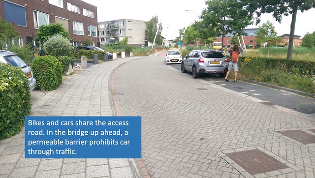
While in Delfgauw, we visited the service road Zuidpoldersingel, which had a parallel access road in a residential development. It had on-street parking, a sidewalk, and there were frequent intersections with minor streets. Because the access road was only a few blocks long and ended abruptly with permeable barriers leading to a bike-only path, it would not be possible for any traffic to spill over into the access road. By ensuring that heavy traffic would not be included in the street design, a bike lane or cycle track did not need to be included.
Bike Highway
Unlike bike boulevards, which direct bicycle traffic along preexisting roads and, along with physical constraints, limit the road’s appeal to bicycle traffic, bicycle highways connect major destinations via a network of exclusive bike paths. This exclusivity extends to special way finding for cyclists on the paths, and limited intersections with streets that cars can operate on.
On our trip to Delfgauw, we visited a bicycle highway which connected a newly built neighborhood to Pijnacker. This right-of-way was partly constructed through the new neighborhood itself, and partly constructed alongside the N470 higway for a few miles, before the two diverged. The section alongside the highway was in a remote area containing large amounts of farmland, and the path itself felt insular and exclusive. A width of over 10 feet allowed for comfortable riding for two people in each direction, if desired. It is also worth noting that in sections that ran parallel to the highway, the bicycle highway was elevated 5 to 6 feet above the highway traffic, in order to protect cyclists in case of a motorist driving off of the road.
