Homework 4:
Site 1:
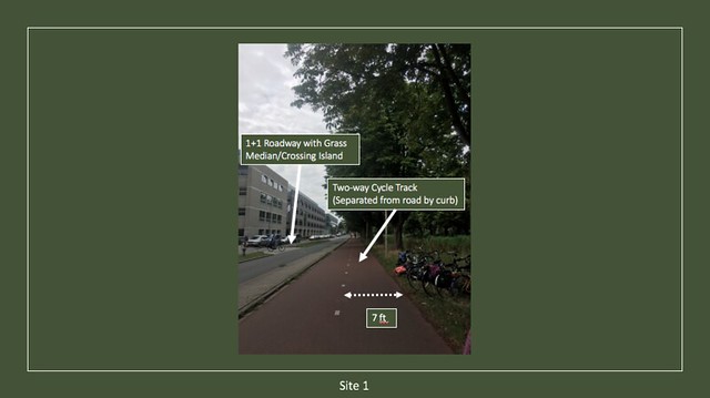
Our first site visit was to Abtswoude path, a 1+1 (one lane for either direction) local street coming off of Mekelweg, the street running the length of the TU Delft campus. Abtswoude path is designated a local street based on its generally low traffic volume and numerous connections to adjacent buildings, parking lots, and other zones of interest. The narrow lanes discourage fast through traffic by not giving vehicles excessive amounts of room to maneuver. Running alongside this path is a cycle track, not to be confused with a bike lane which offers no physical separation between cyclists and the roadway. Given the nature of the roadway and the fact that through bicycle traffic is prioritized based on the cycle tracks separation and assigned right-of-way at intersections, this stretch of cycling infrastructure is best known as a bicycle boulevard. As can be seen in the annotated photo, the 7 foot lanes provide cyclists with ample room to comfortably ride down the track, much more than the standard 4 feet minimum. Slow moving vehicular traffic and the wide curb between roadway and cycle track give riders a strong sense of safety while the presence of trees and a grass median/crossing island create the ambiance that this is a priority route for cyclists.
Site 2:
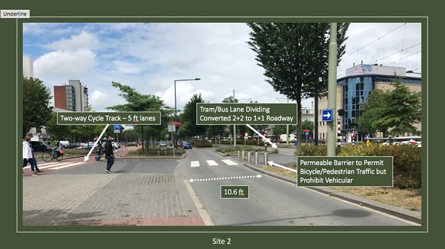
Site 2 highlighted Papsouwselaan, a historically 2+2 roadway that was converted into a 1+1 roadway with cycle tracks and a center lane for the tram and buses. Cars used to come out of the intersection in the back of the annotated picture and speed down these streets because they had the space to do so. Once converted, traffic was forced to enter the single 10.6 foot lane, forcing it to slow down and be more aware of pedestrians and cyclists. As can be seen in the picture, the city installed a permeable barrier perpendicular to the main roadway. This closed the perpendicular roadway to vehicular traffic but still permitted pedestrians and cyclists, continuing the boulevard described in Site 1. The raised crossing islands serve as protection for crossing pedestrians, as they now only have to cross one lane of cycle or car traffic at a time. In other words, the pedestrian only has to make one decision at a time, leading to a much safer experience than the 2+2 roadway provided. Cyclists also have a much easier time crossing the street for the same reason and can continue on their way down the cycle-track seen on the left side of the annotated picture.
Site 3:
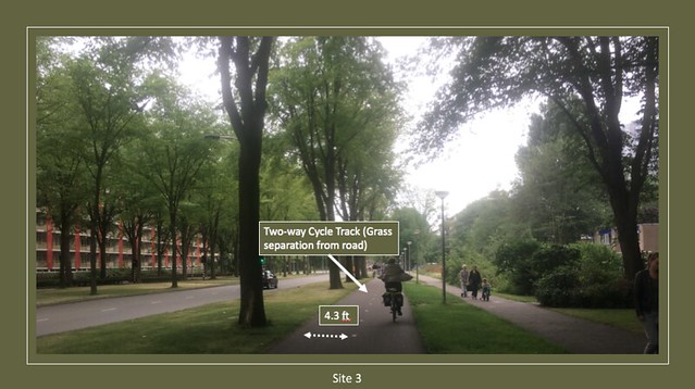
Voorhofdreef at site 3 was a great example of a cycling parkway, a two-way cycle track separated from traffic by multiple feet of grass and trees. This particular street is a 2+2 with a grass and tree median dividing the opposing traffic. Cyclists are provided with a two-way cycle track on both sides of the street for safe and comfortable travel. The relatively narrow 4.3 foot lanes are plenty wide given that there are no hazards directly adjacent to the track. Though the roadway is 2 lanes and traffic moves faster than on a single lane street, cyclists are far enough removed thanks to the parkway features that there is no feeling of danger while riding. If cyclists or pedestrians need to cross the street, there are signalized intersections to do so. The street’s median also acts as a crossing island, allowing pedestrians and cyclists to focus on crossing just two lanes at a time if not at a signalized section.
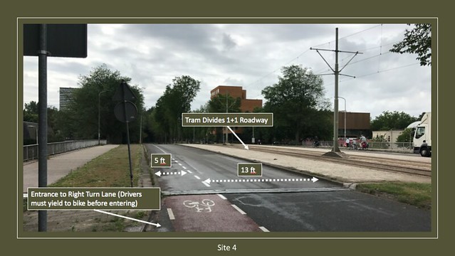
Site 4:
Martinus Nijhoflaan is a 1+1 roadway with tram tracks acting as the median between the two lanes. This street attaches to a roundabout and serves as a collector street to move traffic to its intersection with Buitenhofdreef. In other words, this section of road does not serve as an access to residences or businesses. Cycling infrastructure along Martinus Nijhoflaan includes a 5 foot painted bike lane adjacent to each 13 foot car lane. As can be seen in the annotated picture, the roadway approaches an intersection behind the camera and opens up to include a right turn lane for cars. The bike lane continues on straight and is painted red as a reminder to cars that they will need to yield to cyclists in the lane if they want to cross to the right turn lane. Given the relatively wide street lanes which allow higher speeds and lack of hard separation between cyclists and cars, this section of road is more intimidating to cyclists than others. There are only about 1000 feet between intersections so cars do not have a huge amount of time to pick up speed, but a separated cycle track might help alleviate any fear that a cyclist might have.
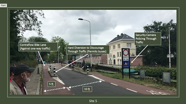
Site 5:
Buitenwatersloot at site 5 is another bike boulevard that encourages through cycling but discourages through vehicular traffic. This street was historically a heavily traveled main highway for shipping, but the city ended up building a bypass road, allowing them to close Buitenwatersloot to through traffic altogether. Buses are still permitted to travel the street but as can be seen in the annotated picture, there are bollards and security cameras put in place to prohibit car traffic. These diversion methods were part of a larger strategy known as “demotion”, the practice of demoting a street from a higher to lower classification. In this case, Buitenwatersloot was demoted from a through road to a one-way local street that is more accommodating to pedestrians and cyclists. Because of the one-way nature of this street, the bike lane that goes against the bus traffic (left lane in the picture) is considered to be a contraflow lane. While contraflow would be a hazard in faster and higher classified streets, the low traffic volume and slow speeds allow for safe sharing of the pavement.
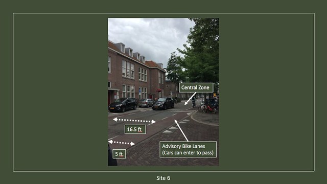
Site 6:
Hugo de Grootstrat at site 6 is a local street that serves residential traffic and includes streetside parking. This site was our first look at a roadway with advisory bike lanes, a system that allows for two-way car traffic on a narrower street than usual. Given the densely populated area and low roadway volume, cyclists feel comfortable biking adjacent to traffic with no physical separation. The lane striping that can be seen in the annotated picture shows a 16.5 foot central zone for car traffic, sandwiched by two 5 foot advisory bike lanes. These are considered advisory bike lanes because they are simply a suggestion as to where cyclists should ride, while the central zone is reserved for cars. When two oncoming cars wish to pass, they simply drive into the dashed lines delineating the advisory bike lanes and go past each other. This system works well because of the quiet nature of the roadway and because cars do not get queued within the street. It falls apart when there are oncoming groups of traffic who must take up the bike lanes for a substantial period of time, rendering them useless for cyclists. Despite its limited drawbacks, advisory bike lanes and a central zone saved enough space in this instance to allow for attractive street side parking for local residents.
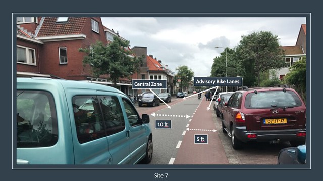
Site 7:
Similar to site 6, Adriaan Pauwstraat is also a local road with a central zone and advisory bike lanes. Parking along both sides of the streets is also provided at this heavy residential zone. Adriaan Pauwstraat’s striking difference is that the total right of way is much narrower than of that of Hugo de Grootstrat’s at site 6. As can be seen in the annotated picture, the central lane is only 10 feet wide while the advisory bike lanes are still a comfortable 5 feet. The same concept of oncoming cars passing by moving into the bike lanes persists and is possible with such a narrow central zone due to the low speed and low volume of the roadway. Cars travel comfortably but slowly in the narrow central zone and have plenty of time to react and move out of the way of an oncoming vehicle if necessary. Traffic volume is not high enough on this local road to make vehicular passing pose a significant danger to cyclists so they too ride comfortably.
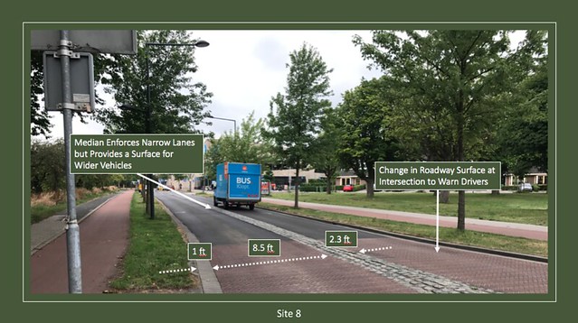
Site 8:
Site 8 provides an excellent example of how clever design can allow a roadway to harmoniously serve two functions. A frequented through road serving a grocery store, Ruys de Beerenbrouckstraat is a collector road providing quick travel that transitions into a local road at a T intersection. The annotated picture shows two one-way cycle tracks sandwiching a 1+1 roadway with cobblestone median and edge zones. While a median is an inherently safe buffer, the cobblestone median in particular provides a surface for wider vehicles to drive on while still giving the essence of a narrow lane to smaller vehicles. Combined with a drivable edge zone to better accept wider vehicles, the seemingly small lanes keep vehicles at the desired design speed while still serving buses and trucks. The change in pavement surface prior to the intersection and entrance to the residential zone is also an effective safety measure. Prior to the intersection, cars ride on stamped pavement and go up a gradually raised crosswalk in order to warn them of potential pedestrians. This slight raise also helps the street keep its function as a collector but slow traffic to transition into a local.
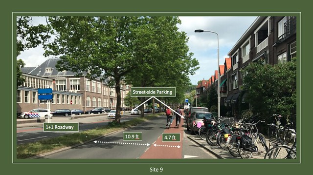
Site 9:
Nassaulaan is a 1+1 street with a bike path and parking running along the length of it. The two motor vehicle lanes are separated by a 4 foot grass and tree median to maintain the 10.9 foot travel lanes and act as a crossing island. Cyclists using the bike lane ride next to cars that come out of an intersection right behind the camera as well as the right turn lane from the intersecting street. Right turning cars must yield to bikers as denoted by the downward facing triangles in the lane. It is worth noting that Nassaulaan has generally larger vehicle lanes than we were used to seeing as well as an under 5 foot wide bike lane next to parking. This does not provide much comfort space as cyclists run the risk of being doored by a park car or riding on the leftmost edge of the bike lane. A better design might be to put the bike lane inside the row of parked cars, to have a parked car and sidewalk on the cyclist’s sides rather than a parked car and car lane.
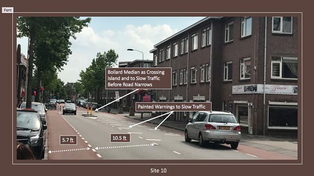
Site 10:
Site 10 gives us a good look at the various speed control measures that can be implemented to have the street behave how it was actually designed. Julianalaan is an arterial roadway serving through traffic that narrows along the length in order to transition into a lower classified road. As seen in the annotated picture, cars encounter both painted road markings and a central crossing island with bollards in order to slow them down. The two opposing bike lanes also bump in at the transition zone, making it even more important to slow traffic so they can react to cyclists. Along with the aforementioned speed control measures, the street also has a speed hump and change in pavement surface at the transition zone to further draw attention to the roadway. Cyclists have a comfortably wide 5.7 foot bike lane to travel in alongside the 1+1 lanes of traffic, though there are parked cars on one side that pose a dooring hazard.
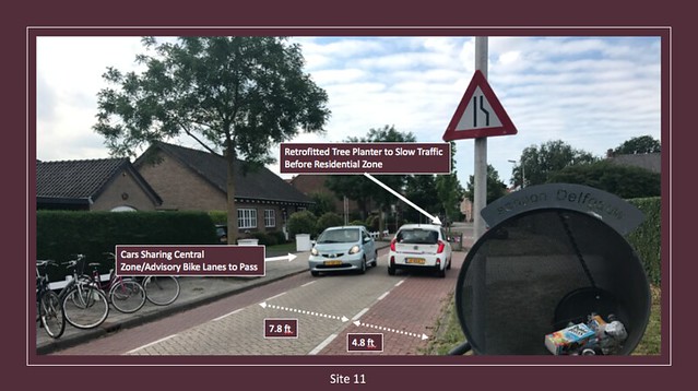
Site 11:
Site 11 again exhibits the practice of a central zone with advisory bike lanes as well as speed control measures. Schimmelpenninck van der advisory is unique in the sense that it abruptly transitions from a very fast arterial to a slow local. To help ease this transition and force cars to slow down, this street was retrofitted with a concrete tree planter at the entrance to the local zone. This requires cars entering the local zone to move across the entire width of the road to pass through the narrow opening, effectively acting as an intersection into the next section of road. As with the other central zones, this 7.8 foot wide area will accommodate one car and if necessary, cars can merge into the advisory bike lanes to pass one another. Another interesting feature that can be seen in the annotated picture is a roadside trash can for cyclists to throw waste into as they go by.
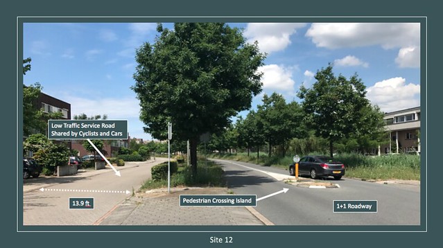
Site 12:
Site 12 showcases Zuidpoldersingel, a 1+1 roadway with service roads separated by trees on either side. Service roads are a low volume, hybrid road that allow cyclists and cars to share the same unmarked lane. As can be seen in the picture, these 13.9 foot lanes straddle the main travel lanes and only serve the houses next to the street. They are strictly local traffic as they lead nowhere, unless you are on a bike and can continue on the connected cycle track. Such wide lanes and low traffic volume result in minimal risk with having two modes of transportation sharing an unmarked space. If a cyclist or pedestrian wants to cross the main travel lanes, they have a crossing island for refuge and only have to cross one lane at a time. Despite Zuidpoldersingel’s generally straight alignment and higher speed, this area is made very safe through the use of service roads.
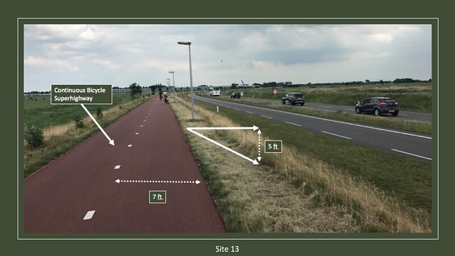
Site 13:
The N470 bicycle superhighway was perhaps the most interesting site to visit. Its continuity, spacious 7 foot wide lanes, and proximity to a vehicular flow road make this superhighway an extremely effective and enjoyable way to get substantial distances on a bike. Just as a highway allows a car to travel fast and straight for a long time, N470 does the same by providing cyclists with a cycle track that encourages long distance travel. Being next to a flow road, cyclists get the feeling that you are on the most efficient route to get to your destination while still being protected by a 5 foot grade barrier. Wide lanes make side-by-side riding a breeze and moped passings easy. As can be seen in the picture, there are no aspects requiring immediate attention such as intersections or turning lanes, letting the cyclist focus more on simply biking and enjoying the ride rather than avoiding danger. In terms of pure land access by bike, the bicycle superhighway tops all other forms of related infrastructure.