Introduction
Ruys de Beerenbrouckstraat and Krakeelpolderweg are two through streets in Delft with a self enforcing 40 km/h speed limit. Krakeelpolderweg is a north south route in the western part of Delft that connects the neighborhoods of Voorhof and Hof van Delft, intersecting the major east west route of Westlandsweg. Ruys de Beerenbrouckstraat is an east west route in the northern part of Delft that connects the center of town to points west, ending at the major north south route of Pr. Beatrixlaan. In the Netherlands, non motorways can only have a 30, 50, or 70 km/h speed limit. Both of these roads have a 50 km/h speed limit, but measures are taken to prevent cars from exceeding 40 km/h. This circumvents the legal restrictions of which speed limits can be implemented, while satisfying residents who did not wish for cars to be driving too fast through their neighborhoods. While the speed above the acceptable speed limit for unsignalized crosswalks, measures have been used to keep cars slow around places where pedestrians are crossing. “Attention grabbers” are used to alert drivers of an imminent crossing as well as to physically slow them down. These include wide crossing islands, narrow lanes, different road surfaces, and raised crossings.
Ruys de Beerenbrouckstraat
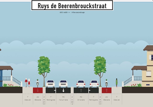
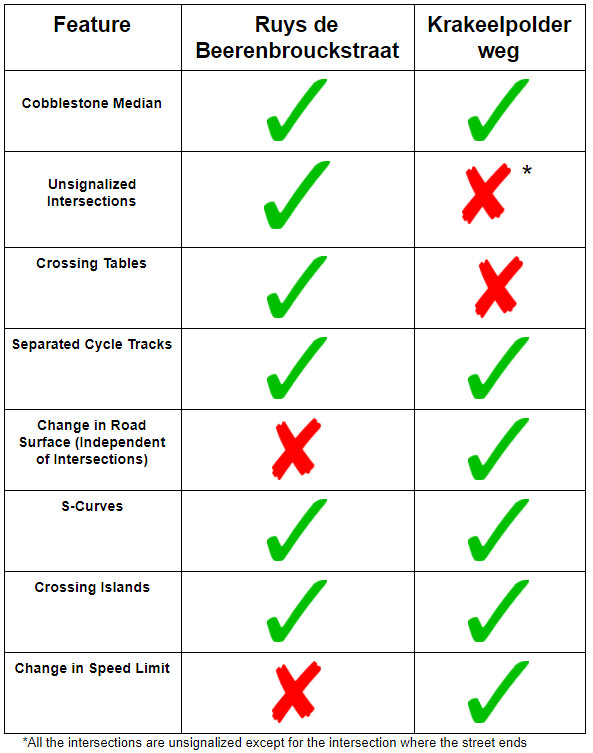
Cobblestone Median/Narrow Lanes
Paint is not used to divide lanes and directions, rather it is a raised cobblestone median. This median can be driven on, but is more uncomfortable for passenger and can force the suspension to do more work, as it is constantly bouncing. From the car’s perspective, this median gives the perception that the lane is narrower with “wiggle room”, which forces the car to go slower. As Ruys de Beerenbrouckstraat is a distributor road, trucks, fire engines, and other large vehicles need to utilize this passage. As seen in the video above, large vehicles can easily drive on the center median due to the vehicles’ larger sizes. The heavier vehicles have larger suspension, meaning it is not as uncomfortable for drivers. At the same time, sufficient access is provided for trucks transporting cargo and fire engines needing to reach an emergency.
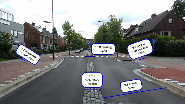

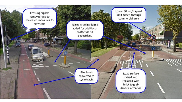
Raised intersections yet no traffic lights
In the event of crossing pedestrians or cars, the road is raised in the intersection to alert the drivers of a risk of turning cars or crossing pedestrians. As in commercial areas where the road changes function (see below), the surface changes from asphalt to red, textured asphalt with a brick like appearance. The cycle tracks also bow out from the intersection to ensure that cars and bikes intersect at a 90 degree angle and increase visibility. The lack of traffic lights yet other measures taken at the intersection and on the rest of the stretch of road follow the Dutch principle of “drive slow, get there faster”. This means that while the average speed may be slightly lower than on other roads in the Netherlands or in the US, the clearly marked yield signs and “shark’s teeth” that give the right of way mean that drivers need to stop less and possibly arrive at their destination quicker than if they followed the American, heavily signalized method of road design.
Fully Separated Cycle Tracks
The cycle tracks follow typical Dutch guidelines and properly separate cyclists from traffic. They are 6.5 ft wide (more than sufficient) and are fully separated from the road. Entrances to side streets that cross the track are raised to keep encroaching cars at low speed. All cycle tracks are also painted red to alert drivers they are crossing an area where bicycles have the right of way.The tracks are raised by curbs and are bordered by parked cars on Ruys de Beerenbrouckstraat to further protect bike riders from passing traffic. Most crossings have “shark’s teeth” to indicate the cyclist’s right of way to create a long, uninterrupted connection for bicyclists from central Delft to points west.
Krakeelpolderweg
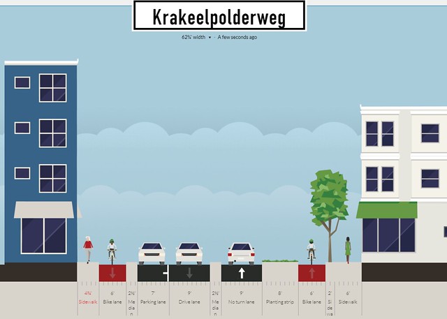
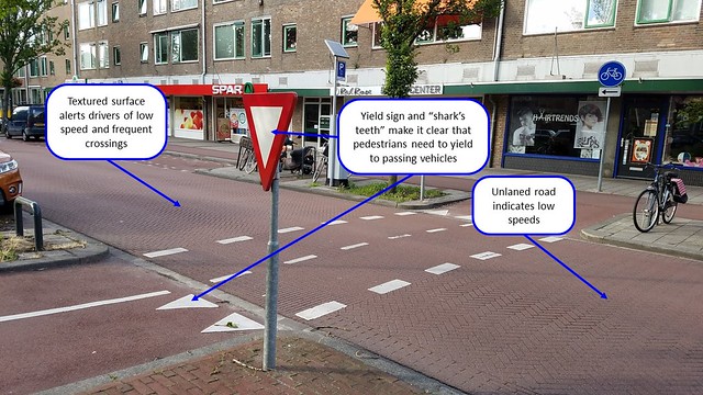
The Changing Road
Even on a street where it is expected drivers go 40 km/h, the function can change, as seen on Krakeelpolderweg. In the middle of the road, its function transitions from a residential through road to a local street with numerous businesses lining one side. The street has been renovated to accommodate this change in function (see annotated photo above). The road surface has been raised as a half speed hump to grab drivers’ attention as well as regulate their speed. Once the road is raised, it changes surface to a textured brick asphalt and changes color from grey to red. This is done to indicate the road’s change in function and as a warning to slow down through a crowded, commercial area. While the rest of the road has a 50 km/h speed limit with a 40 km/h self enforcing speed limit, it is dropped to 30 km/h through the commercial area to minimize risks of collisions and serious injuries. Now that the speed has been dropped through self enforcing measures, unsignalized crossings are able to be implemented to safely allow pedestrians from the surrounding area as well as the parked cars on the other side of the street to cross the street to the businesses.
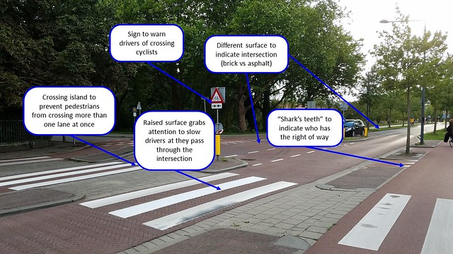
Crossing Islands with S-Curves
Unsignalized crossings would not be possible without using crossing islands. These islands (measured to an average of about 6 feet wide) allow pedestrians to only cross one lane of traffic at a time. This means that they only need to look one direction at a time for only one car at a time. Crossing one lane at a time also eliminates the double threat of potentially not seeing a moving car beyond the first lane. Often before each crossing island, the road bows out to make room for the crossing island while maintaining the lane width. This results in an s-curve or chicane that interrupts the straightway that could potentially encourage high speed. Given that the s-curve is in the immediate vicinity of where pedestrians cross, vehicles must slow down immediately before the crosswalk, minimizing the risk involved with crossing each lane of traffic, and mitigating the injuries that could be sustained in the event of a crash.