
HW4 Delft Ethan Rice
Bike Lanes
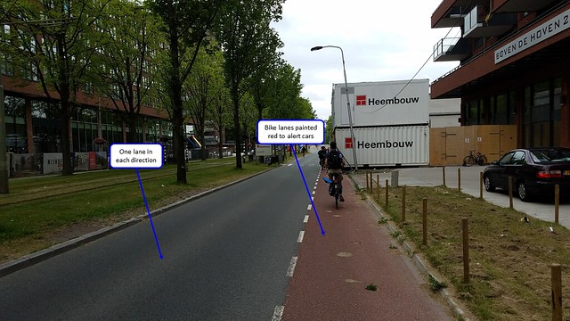
Bike lanes are the cheapest solution to accommodate bicycles on the road. There is no physical separation between bikes and cars, rather it is simply lines painted on the road to guide vehicles into their respective lanes. While this is the cheapest solution, it also poses more risks to bicycles. The lane needs to be wide enough to minimize the risk of getting “doored” by parked cars (assuming the lane is not against the curb) while also being wide enough to minimize the risk of moving traffic in the lanes to the left of the bike lane. The Dutch have criteria to keep bike lanes on suitable roads while minimizing the risk to cyclists. The main place bike lanes can work at 1+1 lane roads with no parking, but lanes that are on 1+1 lane roads with residential, low turnover parking and 2+2 lane divided roads with no parking are also acceptable. While bike lanes are passable, they are even in the midst of attempting to be phased out in the Netherlands. There are 18,000 km of separated cycle tracks in the Netherlands, while only 4,000 km of bike lanes, as the Dutch favor more definitive separation to better protect bicycles.
Site 4: Martinus Nijhoflaan
This is a major east-west street in the newer western part of Delft, connecting to large north-south streets Buitenhofdreef and the rotary where Voorhofdreef and Popsouwselaan converge. As this is in a newer section of town, it was planned to be wide and carry a large number of cars. However, this lane is still in compliance with Dutch regulations: a 1+1 road with no parking. This road has one lane for cars and one bike lane in each direction on either side of a grass median. The bike lanes are wide enough to accommodate a cyclist with room to spare. Furthermore, one lane on each side of the median restricts left turns from the oncoming lane and protects cyclists more.
Site 9: Nassaulaan
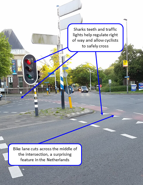
This is the end of Nassaulaan where it meets a large intersection near the northeastern corner of TU Delft. While this is a five way intersection, the bike lanes cut across the middle of the space, with no corner islands or protective barriers. There are not even bike specific traffic lights in all directions. This design would seem more common in the United States, and felt very exposing during the crossing.
Site 10: Julianalaan
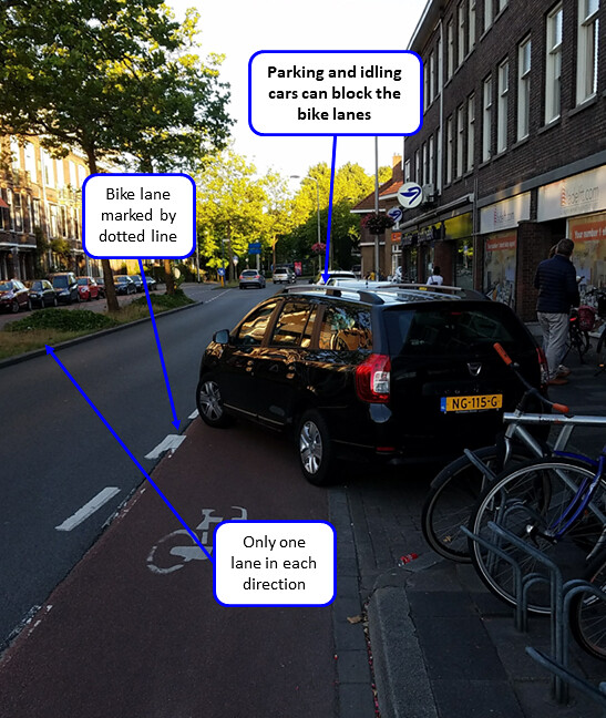
Julianlaan is part of one of the main north-south streets on the eastern side of Delft. It is meant to be equally important to cars and bikes, given its strategic path. The number of shops meant that parking is required, but the photo above showcases one of the shortcomings of bike lanes. Cars like the one shown can either take a long time to park or idle as this one was doing. This requires bikes to either stop, or if they are not able to stop, move into the traffic lane and into danger. The parallel parking next to the bike lane also raises the risk of dooring, but the lane was sufficiently wide to stay out of the door zone.
Cycle Tracks
Cycle tracks are a variant of bike lanes, where they are completely separated from the cars. Usually, this is done by bollards or curbs, but parked cars and landscaping can also be done. Furthermore, bikes can be protected by changing the elevation of the cycle tracks. It can be at the same level as the street, sidewalk, or halfway in between the two. The change in elevation uses a large enough curb so that anyone who crosses in between thoroughfares will know they have. These tracks can be one way or two way (officially or unofficially). If cycle tracks are one way, they must include a safe transition at endpoints to protect cyclists even after they have exited these tracks. Using one way cycle tracks also leads to more complex intersections, as there is a need for more one way tracks to accommodate all directions.
Site 2: Papsouwselaan
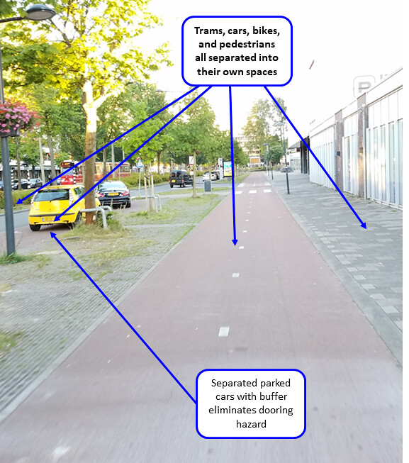
Papsouwselaan runs north and south to meet Voorhofdreef at a major roundabout. This is much more commercial than the road to the south, and brings cars to various east-west thoroughfares that run into downtown Delft. There is a buffer zone that protects cyclists from moving cars as well as setting the track far enough away to disregard the risk of passengers dooring cyclists. The wide path also gave cyclists enough space to not worry of running their wheels on the slight curbs on either side.
Site 3: Voorhofdreef
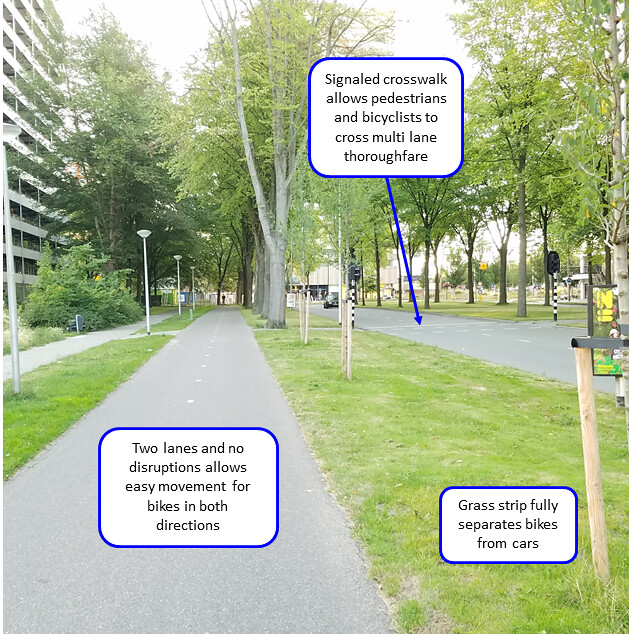
Voorhofdreef is a north-south thoroughfare in the newer part of Delft, and is wide enough to have two two-way cycle tracks, one on each side. It runs through a highly residential area that connects residents to the more commercial Popsouwselaan to the north. Due to the width of the road and 2+2 configuration, signaled crosswalks have been implemented to allow safe crossings. The tracks are wide enough to easily accommodate at least one biker in each direction, and are fully protected by a wide grass median. Riding down this track felt isolated and left no worry of any incident with cars.
Site 8: Ruys de Beerenbrouckstraat
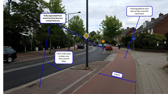
Ruys de Beerenbrouckstraat is a typical neighborhood that has been renovated to accommodate cyclists. Each track is one way, meaning it takes up more space than one two-way cycle track. The almost seven foot width is more than the required 5 foot width. Since these tracks go through a neighborhood, measures were taken to slow cars, such as speed humps, perceived narrow lanes, and raised crossings. While this street connected the center of Delft to outer neighborhoods, these measures were implemented to discourage through traffic and slow existing traffic and allow bikes to safely use the neighborhoods.
Bike Boulevard
A bike boulevard (also called quietway or neighborhood greenway) is a low speed, low traffic street that accommodates bike use. It must be meaningful length (i.e., several blocks, to allow cyclists to easily access another part of town) that follows quiet streets, but also discourage through traffic. There cannot be too many jogs and must be a continuous street while not attracting cars. Cars may be deterred by permeable barriers and contraflows that favor bicycles, while bikes can be attracted by shortcuts across certain land, bridges, tunnels, and minimize stop signs. Since these bike boulevards may change streets several times across their routes, wayfinding must also be used to direct bikers where to go.
Site 1: Abtswoude path, TU to Pr
Beatrixlaan
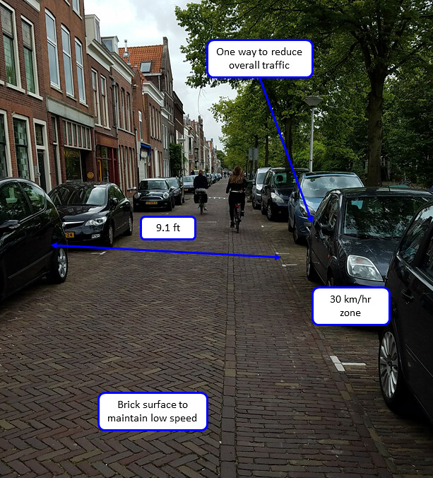
This path connects TU Delft to the communities west of the canal, and partially consists of standalone paths as well bike boulevards. There is a curb to give a path to cyclists, but cyclists are able to ride in the road as well. As there is no motor connection to TU Delft, there is very little through traffic. The traffic that does come down this street is restricted by narrow width and an asphalt brick surface to slow them down. It is definitely safer to ride on the left side (as oriented in the photo) as there are several businesses on the right that cars are turning in and out of. However, it is doable to ride in the road as cars are restricted enough to not pose a threat.
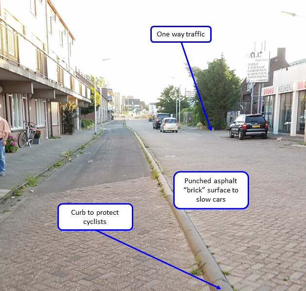
Site 5: Buitenwatersloot
Buitenwatersloot was a major cut through for cars, but has since been restricted to make cyclists more welcome. It used to allow residents to join the center of Delft and access the train station. However, several streets have since been built and widened to allow easier access, so the street was demoted to make it safer for cyclists. It was restricted from two ways to one, and a 30 km/hr zone to indicate a local neighborhood. A permeable barrier (not in photo) is in the process of being installed at the end to allow bikes to access the center but not cars. The narrow width combined with rough surface helps self enforce the speed limit and keep cyclists safe.
Advisory Lanes
Advisory bike lanes (also called suggestion lanes) are spaces for bikes on unlaned, low traffic roads. These roads must have between 2000 and 5000 cars total per day to be considered for advisory lanes. Each bike lane is along the edge of the road, while the middle of the road is unlaned for cars. When the need arises, cars can utilize the bike lanes for extra space to pass oncoming traffic. There is no standard size for the middle space and may vary greatly. This design is able to save space and quiet roads and can bring bike lanes to quiet neighborhoods where there is insufficient space to bring full-fledged bike lanes. However, this shared space may cause some congestion in certain places where cars form lines such as intersections and places leading up to traffic lights.
Site 6: Hugo de Grootstraat
Hugo de Grootstraat is a local neighborhood with low through traffic. It does not have a lot of through traffic as there are larger streets within a couple of blocks that are less restrictive with higher speed limits. That being said, designated crossings like the one shown above are still implemented in the neighborhood. It is surprising that asphalt is used in this neighborhood rather than punched brick asphalt or brick to slow the cars. However, this is made up for with these islands to shrink the width of the lanes. The cars successfully pass slow, but it still feels exposed, especially when the exception speeds by, ignoring the measures taken to restrict speed.
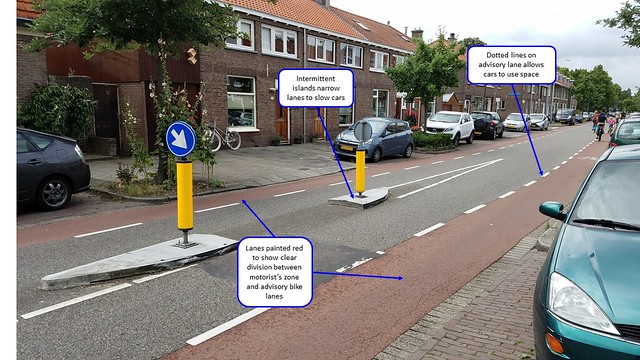
Site 7: Adriaan Pauwstraat,
Westplantsoen
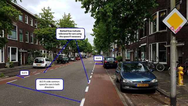
Unlike site 6, this street is more of a distributor road rather than a local neighborhood. That being said, there are still residences along the route. The dotted lines indicate that cars are allowed to use the bike lane to move out of the way of oncoming cars or to go around cyclists. The 16.5 foot central zone is almost wide enough to allow two cars to pass, meaning they do not need to encroach on the bike lane’s space as much as on other roads. However, this cannot be said for all roads with advisory lanes, as there is no standard width for the lanes or central zone.The 4.6 foot wide bike lanes do feel somewhat tight, especially considering the parked cars on the right and being somewhat close to the dooring zone.
Site 11: Schimmelpenninck van der
Oyeweg (Delfgauw)

The road Schimmelpennick van der Oyeweg is a rural road connecting Delfgauw to Pijnacker. This is at the edge of Delfgauw, as shown by the increase in speed limit and no parking. Despite the raised speed limit, measures are taken to limit cars’ speeds. The large 30 km/hr sign painted on the road clearly tells motorists to slow down, while the speed hump resorts to physical means. The change in surface from smooth asphalt to punched bricks gives further indication that a the road was approaching the community of Delfgauw. However, the lack of obstacles and curves means cars can easily speed, regardless of what the speed limit says, resulting in a more stressful experience. Given this is a rural road, it is surprising that it was no widened (considering it had no curbs) to make a full 1+1 configuration with bike lanes.
Service Road
A service road is a space saving alternative to building a cycle track or converting a road to a bike lane. This involves focusing on a road parallel to a main road and accommodating it for bicycle use. This road must be low speed and have low traffic. In theory, it works the same as a bike boulevard, allowing for bikes and cars to share the same space with no separations. At the same time, through traffic is restricted by low speeds, few points to turn back onto the main road, and a relatively narrow thoroughfare overall.
Stop 12: Zuidpoldersingel (Delfgauw)
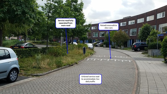
This service road provides access to residences on the right while keeping them off the busy divided road on the left. Zuidpoldersingel was part of a relatively new planned section of Delfgauw and was planned as a low speed shared road from the beginning. The asphalt was punched for a brick appearance to slow cars while speed humps were added as a physical reminder to keep slow. The road is also unlaned to indicate that this is a low speed neighborhood. Since only residents are using this road, the ADT is relatively low. There are also no chances to turn on and off the main road, eliminating the risk of cars quickly turning in front of bikes.These measures allow cyclists to use the full extant of the road safely.
Bicycle Highway
A bicycle highway is a standalone bike path, and usually the fastest way to travel by bike. These bike highways are physically separated from other obstructions and are used to connect communities over long distances. Additional facilities such as lights are used to help bikes ride over long, rural distances. These paths are the safest option for bicycle transportation, as they are fully separated from other motor traffic and therefore, a more pleasant environment to ride in than in a street.
Stop 13: N470 Bike Highway (Delfgauw)
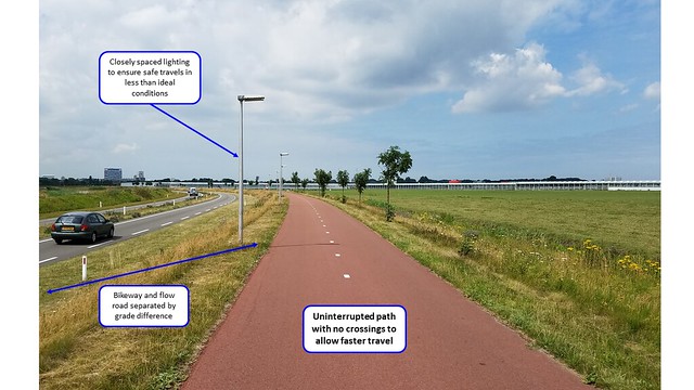
This bikeway along the flow road N470 brings cyclists across the Green Heart with minimal interruptions. The grade separation of the bikeway being 5 feet higher than the road provides safety to cyclists in the event of a car going off the road. It is surprising that no barrier is put in place between the path and the road, but the grade separation is taller than most cars. There are minimal crossings and where there are (not shown in photo), the cyclists have the right of way. The bike highway also is very straight and wide to maintain high speed. The bike highway’s width, separation from other obstacles and abundant lighting ensures safe transit in almost any condition.