
Bike Boulevard
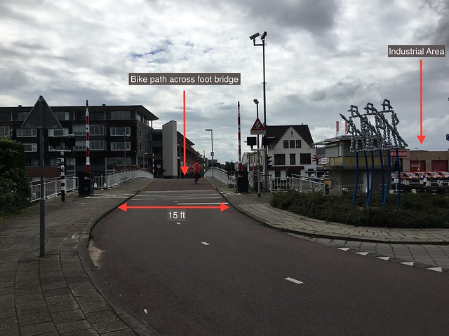
Site 1 (A) —Abtswoude Path, TU to Pr Beatrixlaan
This is a two-way bicycle path that is part of a larger bike route. This route extends through several “quiet streets” with little motor traffic, connecting a university to a nearby neighborhood. The path is wide enough to comfortably hold three or four cyclists. The foot bridge shown is not open to motor traffic, but is strong enough to hold emergency vehicles. Residents of this area need to be able to safely and easily bike to the grocery store on the other side of the bridge. However, not all roads in this area can prohibit motor vehicles since many people wish to drive to shopping area. In addition, the industrial area just over the bridge has fright trucks that need to be able to access the area.
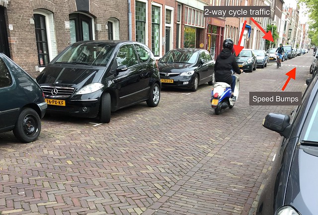
Site 5 (C) — Buitenwatersloot
This narrow street runs alongside a canal near the Delft city center. It is mainly traveled by cyclists and pedestrians, but is open to occasional motor traffic, as is clear by the on-street parking. The street is only wide enough for one-way car traffic, but can easily accommodate two-way cyclist traffic, a function known as contraflow. Speed bumps are also present to slow down motorists and mopeds, which makes it possible for cyclists and pedestrians to share the road.
Cycle Tracks
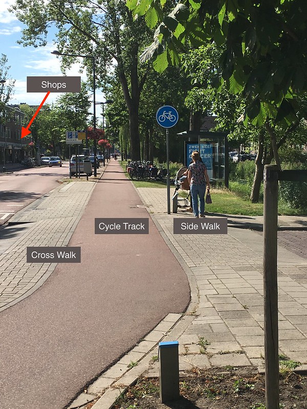
Site 2 (A) — Papsouwselaan
A cycle track is typically found on moderately busy roads between the sidewalk and the travel lanes. In many cases, such as this one, it is elevated so the curb provides additional protection from cars. This also makes it safer for pedestrians to cross the street, since they do not need to check for cycle and motor traffic simultaneously. This is important on this street since nearby shops mean that many pedestrians will cross the street and are likely to at any time, perhaps without first walking to a crosswalk. This road used to be a 2 + 2 road, but it was converted to a 1 + 1 road with 10 foot lanes, as this design forces motorists to drive slowly and safely. For an additional touch, stamped red asphalt is used near the shops as a reminder to drivers to slow down. The design also gives space to street parking, which is necessary for those who drive to the shops.
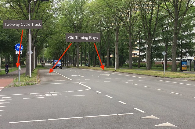
Site 3 (A) — Voorhofdreef
This site is a parkway with two lanes of traffic in either direction. Two-way cycle tracks are used on both sides of the street street, which means bikers do not need to cross the street to change direction. This road used to have left and right turning bays, but these have been removed to slow down speeding thru traffic. This also makes crossing the street safer for cyclists and pedestrians, since rather than having to cross four lanes of traffic at a time (two thru lanes and two turning bays), they only need to cross two lanes. No signals are necessary at this intersection because of this change, meaning that drivers can get to their destination quicker while driving at a slower speed.
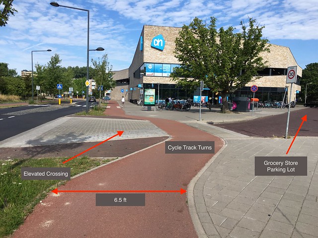
Site 8 (D) — Ruys de Beerenbrouckstraat
This is the driveway into a grocery store in a residential area. The cycle track here turns slightly into the parking area, decreasing the chances of a collision with a driver making a right turn. The elevated crosswalk both acts as a speed bump to slow down drivers and brings them to the same level as bikers and pedestrians who are crossing.
Bike Lanes
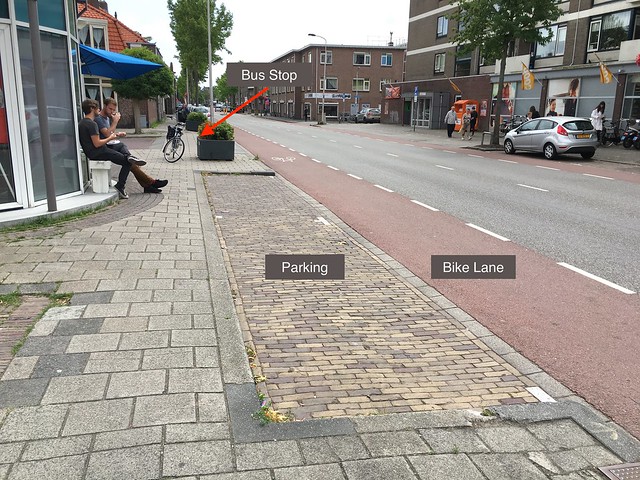
Site 9 (A) — Nassaulaan
This is a bike lane since it is between travel lanes and the sidewalk. While cycle tracks are usually preferred to bike lanes, bike lanes make sense and are safe here. The speed limit on this road is only 30 km/h (19 mph), so bikers are not in great risk of being hit. Bikers are also protected from being hit by an open car door “dooring” since there is a small buffer between parked cars and the bike lane and the bike lanes are fairly wide. Pedestrians exiting the bus are also not at risk of being hit by a bike since when they get out they will be on the sidewalk, not in a bike lane or cycle track.
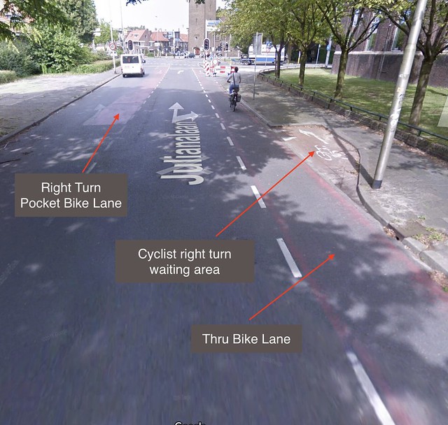
Site 10 (A) — Julianalaan
This is a busy intersection, but the bike lanes are protective. One way to handle bike lane left turns at intersections is to have an additional “pocket” bike lane next to the motor vehicle left turning lane. This could be dangerous since it requires cyclists to cross travel lanes to reach this pocket lane, but is much better than having bicyclists make this maneuver within the intersection itself. To make this maneuver safer, a right turn waiting area is added for cyclists so that they can wait for an opportune time to cross over to the pocket lane. Another safety feature at these types of intersections is to signal for the cyclists enter the intersection before the vehicles so that they can easily be seen and have time to clear the intersection before many vehicles enter. Despite the complexity of this intersection, it was pretty easy to drive through it from the different surrounding streets.
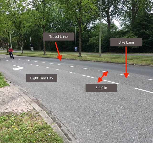
Site 4 (B) — Buitenhofdreer
This bike lane is on a moderately busy road with a 50 km/h (31 mph) speed limit. This is less safe than other bike lanes for a couple of reasons. First, it is not pained red, so drivers may miss that it’s a bike lane and not look for bikers. Second, right-turning vehicles must cross the bike lane to get into the right turning bay. While this can be perfectly fine at times, the length of this particular turn is at least 100 ft long, which creates many points of collision between bicyclists and drivers. However, this later is longer than the recommended 4-5 ft lane width, which is important since there is motor traffic on both sides so the extra width provides protection. Since there is plenty of empty space to the right of the roadway, perhaps a cycle track can be built to improve this roadway.
Advisory Lanes
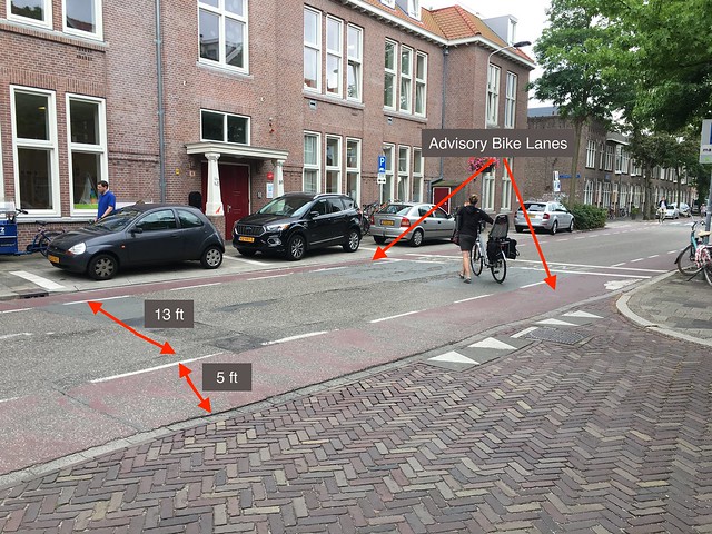
Site 6 (C) — Hugo de Grootstraat
These advisory bike lanes are in a school zone. Technically, this is a mixed traffic road, but cyclists are advised to stay in the 5 ft lanes on the sides of the road. Although this is a two-way street, the center area is only 13 ft, which is not wide enough for two cars to safely pass each other. In this case, the cars should use the whole road and veer into the advisory lanes as needed, as long as no bikes are present there. The purpose of this is to make negotiating space easier between motorists and bicyclists.
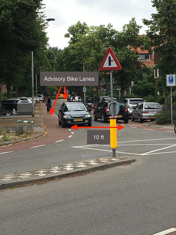
Site 7 (C) — Adriaan Pauwstraat
Here, advisory lanes are used on an even narrower street. The center area between the lanes is only 10 ft wide, so cars must frequently enter far into the advisory lanes to pass each other. The bikers ride towards the left side of the advisory lanes to avoid being doored by parked cars, making the center space even narrower. As a result, they will be forced to drive very slowly, especially when several bikers are present as shown in the picture. This is a great example of how space-efficient an advisory lane design can be.
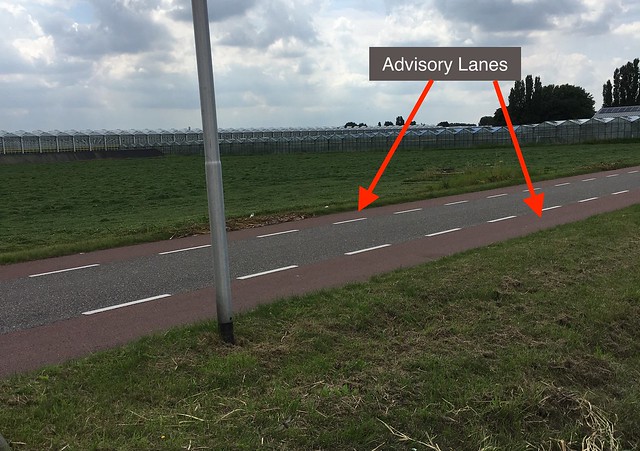
Site 11 (B) — Schimmelpenninck
These advisory lanes are on a quiet, country road which is a great roadways for cyclists. The advisory lanes remind drivers that bicyclists could be found along this roadway, so drive slowly and stay towards the center of the road except when passing cyclists or oncoming traffic. Speed bumps are also used frequently along the road. This smooth, straight road could easily become a speedway if these features were omitted, which would put cyclists in a dangerous situation. For motorists who want to drive faster or cover a longer distance, there are nearby parkways available. The advisory lanes can be slightly narrower than normal here since the absence of a curb or parked cars allows cyclists to safely ride close to the grass. However, due to the low motor traffic volume, cyclists are permitted to use the whole width of road. Pedestrians can also safely walk along the road, or on the grass.
Service Road
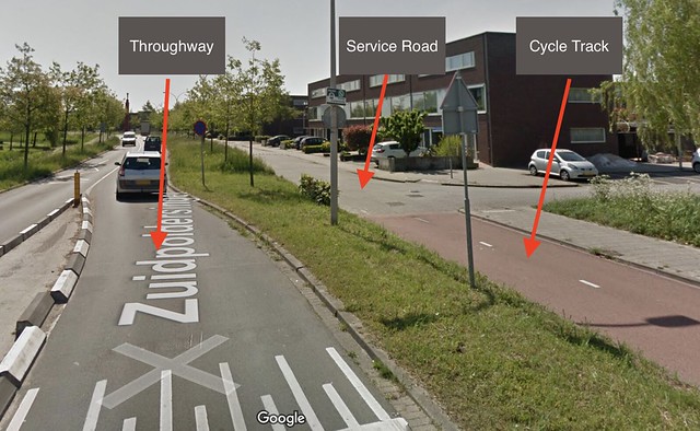
Site 12 (C) — Zuidpoldersingel
In this case, the cycle track abruptly ends and connects to a local service road. This service road is meant to provide easy access to homes rather than having them be right on a busy throughway. Residents can leave their homes on this street and then enter the throughway to travel a longer distance. Therefore, it is acceptable for cyclists to delay motorists for a short period of time, which is often less than a block. Motorist speeds on this road are slow enough to allow for mixed traffic, making it a safe road for cyclists. Although pedestrians could probably walk in the street, a sidewalk is provided for additional safety and comfort.
Bike Highway
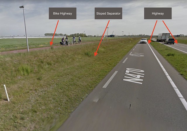
Site 13 (C) —N470 Bike Highway
This is a bike highway alongside a car highway. Since some nearby cities are close enough to bike to, this gives people the opportunity to safely do so. The bike highway is separated from the motorist highway and raised above it, so cyclists are not in danger if a car veers off the roadway. Since, unlike cars, bikes do not always have bright lights, the bike highway is lighted at night by light posts. This bike path was built through a new suburb, so the designers did not need to worry about adding it to the existing highway. One thing missing from this design is a pedestrian path, but it is unlikely that many pedestrians would want to walk this far, and they can always walk on the grass.