
2.4 Prevent cut through traffic on country roads [Stacey]
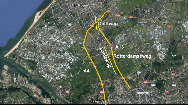
Figure 1: Map of sites
Preventing Cut Through Traffic From Using Country Roads
In the Netherlands, systematic safety measures have been taken to encourage “functional harmony.” Functional harmony occurs only when a road’s functions are mutually compatible.
This occurs when a road is serving its intended purpose.
During this video, we will look at three country roads in South Holland- Schieweg, Rotterdamseweg, South of Delft and Delftweg, North of Delft in Rijswijk. At these sites, traffic engineers used different methods to discourage drivers from cutting through these areas since local country roads are incompatible with carrying thru traffic. In addition, locals do not want cut-thru traffic to pollute their country road, since there are bypass roads available. A country road’s main function is to serve as a beautiful, scenic route for cyclists as well as access for cars to local farms and villages. In order to achieve functional harmony on country roads, they must have few motor vehicles and all vehicles must be travelling slowly since country roads are incompatible with cars going fast.
Schieweg and Rotterdamseweg
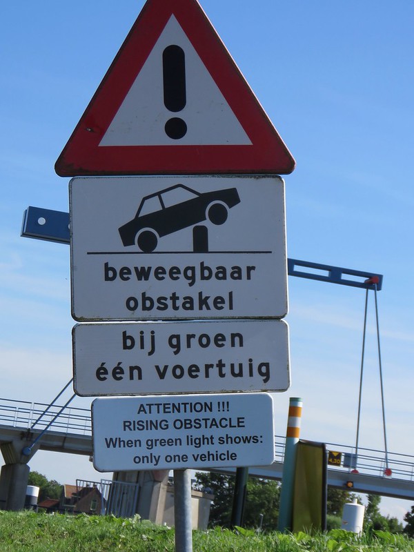
Figure 2: Sign for meter on Rotterdamseweg
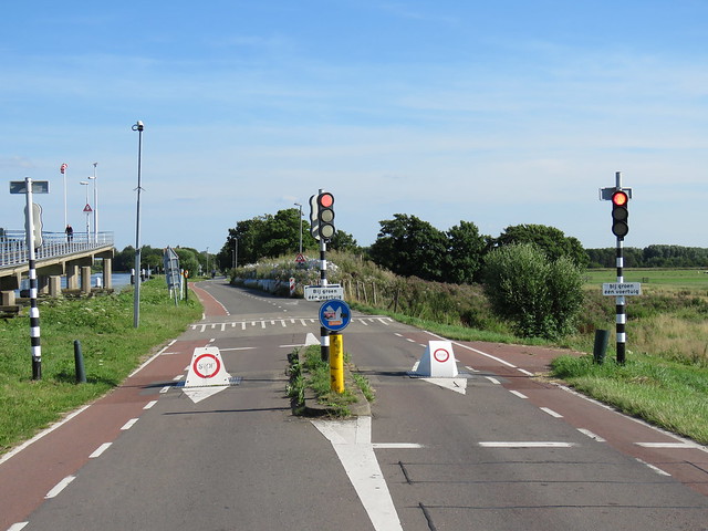
Figure 3: Picture of metering on Schieweg/ Kandelaarweg
Connecting the city of Delft to the large shipping port city of Rotterdam are two major motorways- the A13 and the A4 recently built environmental highway. The motorway should encourage drivers to use it since unlike country roads, it allows for higher speed; however, Rotterdamseweg is also a direct route from Delft to Rotterdam. Once the second motorway was built, they decided to meter traffic on Rotterdamseweg by adding a light. However, across the river, the narrow country road Schieweg/Kandelaarweg has been metering for much longer. Both roads use a traffic light with signs warning of a rising obstacle, limiting one vehicle per green. However, it should be noted that Rotterdamseweg, during non-busy times, leaves the light yellow, since traffic is light enough.
Delftweg
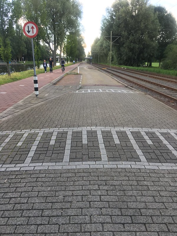
Figure 4: Use of bayonets for volume and speed control on Delfweg
North of Delft, connecting Delft to The Hague the official seat of government, is the old highway Delftweg. Similar to Rotterdamseweg, Delftweg was an old highway; however, it has been demoted to be more suitable for its high cycle traffic and also leaving room for a tram line. Instead of traffic lights, Delftweg uses bayonets, where cars must enter, go left through a narrowed road, exit and merge back to the right. The bayonets are effective for both volume and speed control since the combination of narrowed roads, chicanes and raised speed tables force drivers to slow down and become more aware. Similar to a one-lane bridge, cars going one-direction can continue, while cars traveling in the other direction must wait. This is effective for volume control since the bayonets would cause a jam during high traffic.
Since very little traffic was observed on both of these roads, it may be concluded that using systematic safety techniques, the roads have successfully been demoted and functional harmony has been achieved.
Recommendation for a Place in the U.S.
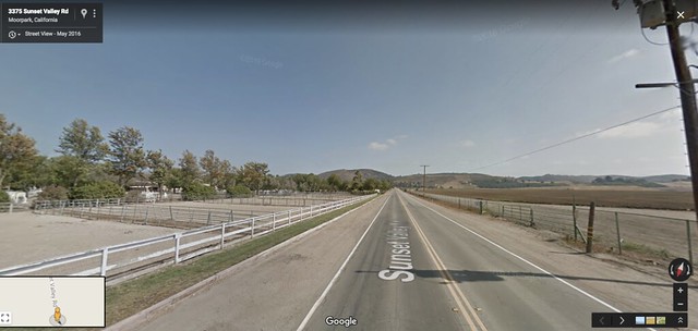
Figure 5: Streetview of Sunset Valley Road in Moorpark, CA
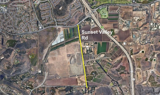
Figure 6: Aerial view of area
Moorpark, California is home to both many homes, farms and barns. Sunset Valley Road in Moorpark, CA is a straight 1+1 country road. Along this road are entrances to two horse barns, a local organic farm, and a few private properties. This road is a 40 MPH zone; however, many people cut through this road instead of using the main distributor road to the west Moorpark Road.
To achieve functional harmony on this road, measures taken similar to those on Delftweg could be used to minimize the cut through traffic on this road. Similar to Delftweg, bayonets or simply chicanes combined with narrower streets would help deter drivers from using Sunset Valley Road instead of Moorpark Road. Narrowing the road would also allow for a more pleasant street for the local users, since many cyclists enjoy this road already. Another recommendation would be an addition of a multi-use path, for mixed horse and pedestrian use since many horses are held in the area. Delftweg also used a dead end; this would be useful at the most southern end of Sunset Valley Road, since it would force a Dutch-like ring road consisting of the 23 Freeway, Tierra Rejada Road, Moorpark Road and Read Road.
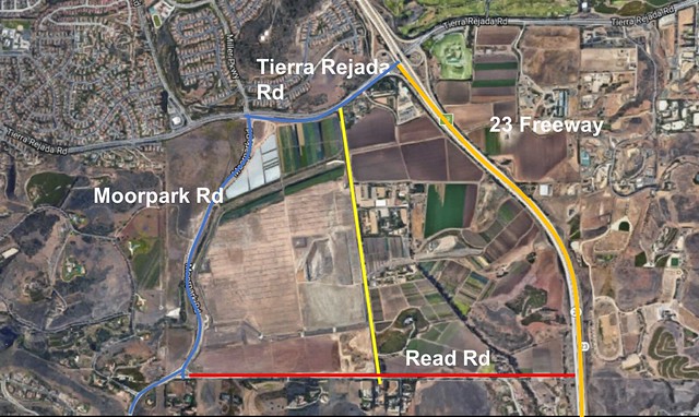
Figure 7: Possible ring road structure