
Charles Street Redesign
Peter’s Desciples
Clare • Jackson • Max • Jude • Anthony
Introduction
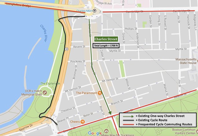
Figure 1 – Map of Charles Street and Surrounding Area
The segment of Charles Street in question is a one-way span connecting Charles Circle in the north to Beacon Street in the south, effectively linking the Longfellow Bridge (from Cambridge) to The Boston Common (Figure 1). This area of Charles Street is approximately 1700 ft long and has a 60 foot right of way from storefront to storefront. Through traffic is able and encouraged to cut through Charles Street, facilitated by three lanes that are almost never at capacity. An abundance of boutique shops and restaurants make this street a place where people come for the experience and a popular shopping and eating destination for locals and tourists alike. The businesses on Charles Street are typically busiest on Saturday and Sunday. On average, there is an ADT of 4200 cars running south on the one way, three lane street. Vehicular cycling southbound is the only legal option for bicycles. In order to commute back to Cambridge, as many as a third of the daily bicycle traffic is compelled to illegally ride contraflow back to the Longfellow Bridge.
Parking in Beacon Hill is extremely sought after, with any reduction in parking sure to meet harsh criticism. None of the many high-end restaurants on Charles Street currently have the space to accommodate outdoor seating due to the narrow 7.5 foot sidewalks. There are no bus routes running through or on the road and the closest T station is Charles/MGH to the north while the closest bus stop is on Beacon Street to the south. The closest public parking garage is the Boston Common Garage, a mere quarter mile away from the center of the Charles Street Beacon Hill segment. There is also a private parking garage on Charles, which solely caters to Beacon Hill residents who purchase spots.
Existing Conditions
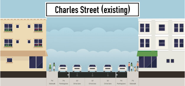
Figure 2 – Existing Charles Street Cross Section
With three lanes of traffic and two lanes of parking, Charles Street has a 45 foot wide swatch of asphalt (Figure 2). Although through traffic is one of the main functions for the road right now, the three lanes are never filled. Regardless, we do not think it should be a through way at all with its potential to become a much more appealing and heavily foot-trafficked area.
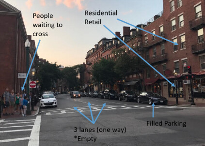
Figure 3 – Current Conditions on Charles Street
Currently, the three car lanes are 10 feet wide with 7.5 foot wide parking lanes. Figure 3 perfectly demonstrates one of the main problems with Charles Street and how the travel lanes are not nearly at capacity while the sidewalks are practically overflowing. The parking, on the other hand, is constantly at capacity. The photo above also shows how mixed the current space is with residential and retail space. The present elements are key components to making a “livable” street but need to be adjusted to achieve the desired effect. With trees, multiple modes of transportation, and things to do, people are naturally attracted to this area.
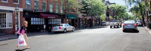
Figure 4 – Pedestrian jay-walking across three lanes on Charles Street
Even though the Beacon Hill section of Charles Street has some of the highest pedestrian volumes in the city, the sidewalks are only 7.5 feet on either side, including space allocated for trees and parking meters. Also, because pedestrians are not able to safely cross the three lanes on an unsignalized crosswalk, they are not given a sufficient amount of crossing as they are only able to cross at the intersections at signalized crosswalks. (Figure 4). In other words, you have more asphalt than the vehicular traffic demands and not enough pedestrian infrastructure for a high foot traffic demand.
Parking is a significant issue in Boston, with Beacon Hill arguably being the most contested area for parking spaces. Residents of the area are allowed to register an unlimited amount of cars for a parking pass, even if there are no physical spots to house them. Charles Street has two lanes of metered parking, totalling around 120 parking spots and being highly important assets for businesses and residents alike. The spots appear to be well utilized, signaling that a reduction in spots would be very inconvenient for anyone using a car. Meanwhile, pedestrians would benefit because they would have a more attractive area where they would be less threatened and stressed by motor vehicles.
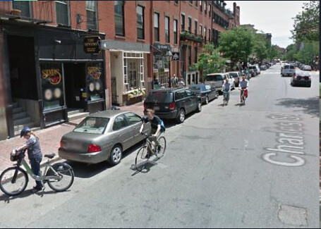
Figure 5 – Contraflow Cycling on Charles Street
Charles Street is a common shortcut route for bicyclists. It is more direct than the Esplanade path, especially when trying to get between the Longfellow Bridge from Downtown Boston. Yet, one-third of cycle traffic is contraflow (Figure 5). The redesigned Charles Street must meet the needs of cyclists who otherwise have to break the law and put themselves at risk of being struck head-on. This means designing a road that allows for cyclists and drivers to share the road harmoniously.
Vision
The primary intent of the redesign is to make Charles Street more appealing and accessible to foot and bicycle traffic, as that demographic is an afterthought with the current conditions. The design strives to make a pedestrian-friendly street that is also accessible and safe for cyclists wishing to travel both northbound and southbound. As mentioned, cyclists are already traveling both ways although prohibited on one, so allowing them to do so safely and legally is a must. Since having through traffic on Charles Street degrades the area by bringing in unnecessary vehicular volume and puts pedestrian and cyclist lives at risk, it must be eliminated entirely. A crucial step in ensuring safety in the area is limiting speeds to 20 mph. Lower car speeds drastically reduce the damage done in a vehicular accident with a soft body. With limited car volumes and speeds comes the goal of having safe and permitted two way bicycle traffic on Charles. Eliminating traffic lights on our segment of Charles St has the effect of reducing delays. With no traffic lights, pedestrians will have more autonomy and liberty to cross the streets rather than make them cross at designated points. It will allow for a more smooth flow of traffic while forcing drivers to connect with their surroundings than relying on a light for when to go. This will connect the drivers with pedestrians and cyclists.
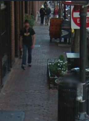
Figure 6 – Insufficient Sidewalk Space for Pedestrians
This design team believes that safely integrating all types of transportation present on our street is essential in establishing a “plaza-like” feel. Pedestrians and cyclists alike should feel as if they have as much priority on the road as passing cars do.
Inspiration
Wagenstraat is located in the Chinatown district of The Hague and features raised parking on one side. Some of the parking is restricted at certain times in the morning for delivery trucks catering to restaurants and miscellaneous grocery stores.
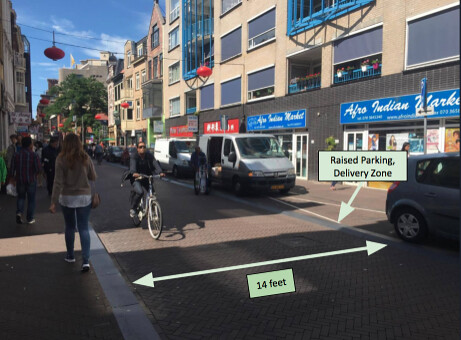
Figure 7 – Wagenstraat, The Hague NL (Chinatown)
As seen in Figure 7, a cyclist rides confidently, almost in the middle of the road. Cars were witnessed on this road proceeding behind bicycles without attempting to pass them due to the large presence of contraflow cyclists. Much like Charles Street, Wagenstraat is not wide enough to allow a car and two bikes, one traveling in each direction, to all safely be next to one another or pass one another. The only way this could be possible is if valuable parking or sidewalk space was eliminated. Cars moving in the same direction as bikes must stay behind, and are not significantly impacted, since both Wagenstraat and Charles Street are not too long. The maximum distance that a car will have to proceed on a stretch of Charles Street is .14 miles. Even at 10 mph (a typical cycling speed), a car will only spend 50 seconds behind a bike, only twice as long as when no bikes are present.
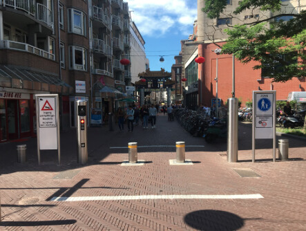
Figure 8 – Retractable Bollards on Wagenstraat in The Hague
The retractable bollards seen in Figure 8 in the car-free area on Wagenstraat were also an inspiration for the Charles Street Redesign. These permeable barriers can be controlled by access codes or by swiping a card by delivery or emergency vehicles while allowing pedestrians and cyclists to continue through unaffected. This method allows for a road to exist for a certain stretch to cater to pedestrian and bicycle traffic while prohibiting cars entirely. This allows for extensive implementation of outdoor seating along this block with a plaza-like feel. Although delivery and emergency vehicles need to get through, this will be infrequent enough as to not cause a major disturbance to the pedestrians.
Charles Street Traffic Pattern Adjustment and Flow Analysis
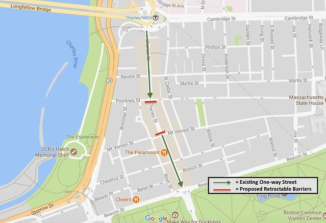
Figure 9 – Initial Redesign of Charles Street Traffic Pattern
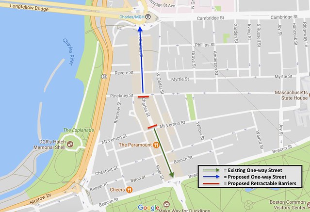
Figure 10 – Final Redesign of Charles Street Traffic Pattern
In order to meet the goal of transforming Charles Street into a multimodal plaza, major adjustments to the existing traffic patterns must be made to reduce the amount of vehicles using the street. As previously stated, the Beacon Hill segment of Charles Street is one-way southbound, allowing through traffic to traverse from Charles Circle to the Boston Common area. Initial design deliberations resulted in the proposal of completely shutting off the block between Pinckney Street and Mt. Vernon Street to all vehicular traffic through the use of retractable bollards (Figure 9). These can be lowered for emergency and delivery vehicles that need to get within the area. Charles Street will continue to be one-way southbound on the north and south sides of the traffic free block with through traffic encouraged to use either Storrow Drive or Cambridge Street to reach the Common area. While this traffic pattern initially seemed sound, it was thought that through traffic would continue to utilize Charles Street as a cut through, using Brimmer Street or West Cedar Street to bypass the car free block.
After taking a step backward and reevaluating the through traffic dilemma, it was decided to convert the section of Charles Street north of Pinckney Street into one-way northbound (Figure 10). This will prohibit any sort of through traffic from using Charles Street and force drivers to revert to the preferred Storrow Drive or Cambridge Street Alternatives. All Beacon Hill neighborhoods are still accessible using the existing side streets with current traffic patterns, adding no more than a few minutes to a resident’s commute.
Converting Charles Street into a shared use roadway that can safely accommodate cars, cyclists, and pedestrians is an ambitious yet achievable goal. There are numerous challenges that must be addressed but the first step is ensuring that the resulting traffic volumes will, in fact, be low enough to allow for a such an environment. In its current state, Charles Street has about 7 cars passing through in one minute during peak hour, equationg to 420 cars during the entire hour. Assuming peak hour traffic is 10% of the average daily traffic, the existing Charles Street has a an average daily traffic volume (ADT) of 4200. Standard traffic criteria require that a shared use street, such as what is being proposed for the redesigned Charles Street, have an ADT of less than 2000.
In calculating anticipated ADT for the redesigned Charles Street, it is first assumed that all through traffic will be eliminated through the new traffic patterns. Next, an aerial photo of the Beacon Hill area is used to count a total of roughly 2000 visible cars. This value is increased by 50% to 3000 cars, accounting for any “invisible” cars that may be parked in garages or otherwise hidden from sight. Given that the Beacon Hill area stretches nearly half a mile wide, it is assumed that half of the total number of cars will actually use Charles Street rather than a more convenient option, leaving 1500 in the Charles St. area of influence. Lastly, since Beacon Hill parking spots are considered very valuable and residents want to hold on to them, it is assumed that each car is making a round trip once every two days. Therefore, if each of the 1500 cars take a trip every other day, then the residential ADT is 750.
Further, there are about 100 parking spots on Charles Street after the redesign and each spot is estimated to have 6 turnovers every day. Therefore, parking contributes an additional 600 to the overall ADT. Each of the approximately 30 shops are estimated to have 1 delivery per day, contributing an additional 30 cars to the ADT. Finally, an estimated 200 taxis/ride-sharing passthroughs every day increase the ADT by another 200.
When all of these individual traffic volumes are totalled, the ADT for the redesigned segment of Charles Street is calculated to be 1580. This number is well below the recommended 2000 ADT to justify mixed bicycle and car traffic with unmarked pedestrian crossings.
Proposed Street Design
Once the traffic flow has been brought down to around 1600 ADT via the adjusted traffic patterns, an entirely new road design can be considered. In order to have mixed bicycle and car traffic on a road, the preferred ADT is less than 2000. The new ADT is well under this threshold and from this point, mixed traffic can be considered as a safe option for travel for bicycle and car commuters.
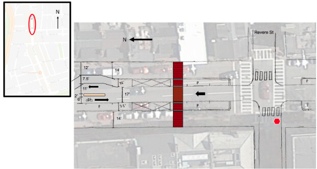
Figure 11 – Plan view for car-accessible areas of Charles St.
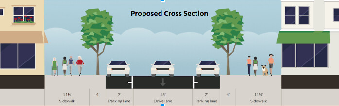
Figure 12 – Proposed Typical Cross Section for Charles Street
For the entirety of Charles Street, with the exception of the block from Pinckney Street to Mt. Vernon Street, the road will consist of a 14’ sidewalk and 7.5’ of raised parking on each side with a 17’ center area for mixed bicycle and car traffic (Figure 12). The parking will be separated from the sidewalk by a small strip of gray asphalt or concrete to signify the border and from the moving traffic by a small, bevelled ramp of the same material in order to allow cars up to park. The presence of raised parking will ensure that cars enter into the spots at lower speeds, as they are potentially crossing over bicycle traffic in doing so. Certain areas of parking will be crossed out in order to provide areas always available in case a delivery is needed outside the normal hours.
The 17’ central area will be comprised of one large brick lane, where cars and bikes mix. If there is a car proceeding behind a cyclist, with a contraflow bike coming towards them, they should not be allowed to pass the bike in front of them. Even if there is no contraflow bike approaching, we expect the cyclist in front of the car to move into the middle of the lane. Charles Street will truly become a mixed road, and therefore cars have to modify their speeds according to the person in front of them, whether it is a car or cyclist.
In order to maintain a speed of 20 mph between blocks, certain speed control measures need to be taken. In order to do this, the road is diverted for a certain period of time with a chicane (shown on the left hand side of figure xx). In this area, bikes going against the flow of motor traffic are given a 6’ space to continue travelling while cars and parallel travelling bikes need to take a slight turn around the median placed in the middle, through the 11’ temporary lane, and back into the flow of traffic. If one of these are implemented in each block, it will assure speed control of the desired 20 mph.
Traffic coming perpendicular to Charles St. (this will be one-way with the exception of Mt. Vernon), will be given a stop sign and will be required to yield to pedestrians at this junction. Cars going through Charles will be allowed constant flow, but in this area pedestrians will be crossing the road anywhere so they will need to be driving slow enough to be able to allow for safety of pedestrians and bicyclists.
Given the road texture and width and mode, this road will maintain a 20 mph speed limit, which is sufficient for mixed car and bicycle traffic as well as pedestrians crossing anywhere on the road. The ability for people to cross wherever they want supports the plaza feel that is being attempted with the change in design.
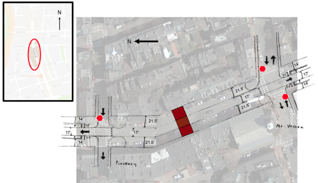
Figure 13 – Overview of block from Pinckney to Mt. Vernon
On the block from Pinckney to Mt. Vernon, bollards will be placed on the entrances in order to prevent cars from getting into this pedestrian plaza area. These bollards will retract for those who have a need to get inside (delivery trucks and emergency vehicles). At the intersections on either side of the area, motor vehicles will need to choose between continuing through on the road they are on or heading on Charles northbound from Pinckney and Southbound from Mt. Vernon. Bicycles will be able to travel through the bollard and enter into the plaza-block, which allows for continuity in their commute up and down Charles St.
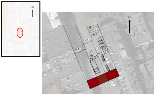
Figure 14 – Plan view within restricted area
Once pedestrians, bicyclists, and delivery trucks enter into the restricted zones, they are greeted by a level 60’ brick surface divided up into three sections. The center zone of 17’ is left as is, although it now has a single texture and is a continuous area. Within this zone, bicycles will easily be allowed to travel and when delivery trucks need to pull over, there will still be 8.5’ minimum within this central lane for the bicycles to get around.
On the outsides of this central lane are two 21.5’ side area of continuous brick. On this area, there is plenty of area for pedestrians to cross as well as room for outdoor restaurant seating, benches, bicycle parking, and general decorations. With all of these additions, the block gains an extremely pedestrian-friendly area and immediately becomes a destination for pedestrians and bicyclists to enjoy an outdoor meal or sit and enjoy a nice day without the stress of constant car traffic.
Parking
Metered parking spaces are currently available on Charles Street from 8 am to 8 pm, Monday through Saturday. Vehicles may park here for up to two hours during these times before being ticketed and eventually towed. These spaces revert to unmetered, limit-free parking from 8 pm to 8 am unless a sign indicates otherwise for street cleaning, snow removal, or designated delivery times. As a part of the Charles Street redesign, streetside parking will follow the following format:
- Monday through Friday:
- Metered with 2-hour Limit: 8 am to 8 pm
- 2 spots per block on either side of the street will be reserved for delivery vehicles from 8 am to 12 pm
- Resident Permit Holders: 6 pm to 8 am
- Permit holders will be able to park unmetered from 6 pm to 8 am but will need to compete for spots with destination traffic from 6 pm to 8 pm, after which it will be permit holders only.
- Weekends (8 pm Fri – 8 am Mon):
- Metered parking all day but permit holders can park for free if desired
This parking scheme will provide destination traffic with continued parking availability and allow for unobstructed delivery service for the various shops and restaurants. Those who wish to visit the Charles Street area after 8 pm can park in the Boston Common garage, a 9 minute walk to the midpoint of the redesigned segment. Since the Charles Street redesign includes the removal of about 40 parking spots in the car free block, some of which are used by commuting Beacon Hill residents, the introduction of permit-holders only parking will give affected residents increased parking opportunities outside business hours.
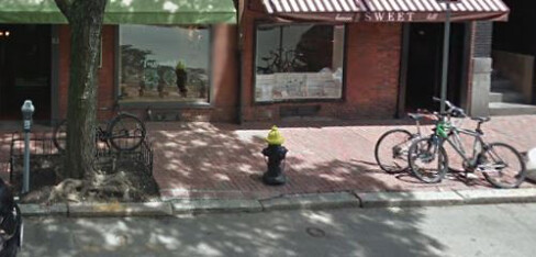
Figure 15 – Current Bicycle Parking on Charles Street
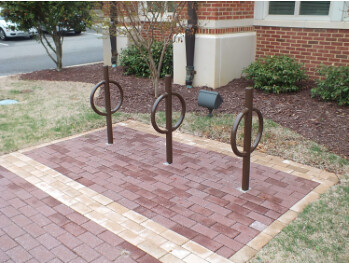
Figure 16 – Potential Bicycle Rack Option
With the introduction of a shared street and more bicycle friendly zone comes a need for adequate bicycle parking. Cyclists who currently want to park on Charles Street are forced to lock their bikes to sign posts, lamp posts, or tree planter frames (Figure 15). The redesigned 15.5 foot sidewalks will provide ample space for the installation of secure and attractive bicycle parking (Figure 16). These racks will be placed in the empty spaces between tree plantings and lamp posts, giving cyclists a further sense of belonging without being obtrusive to the sidewalk and storefront areas. Though not all empty spaces along the sidewalk will be used up by bicycle parking, the racks are simple enough to install that parking can be easily expanded as demand increases.
Conclusion
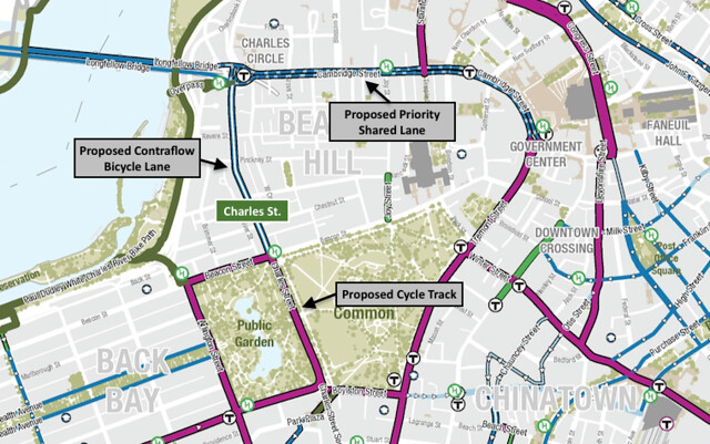
Figure 16 – Map showing Charles Street’s role in the Boston Bike Network 5 Year Plan
The proposed design changes Charles Street from a busy through road into an attractive, livable street that welcomes pedestrians and bicyclists. For pedestrians, the sidewalks will be widened to allow for outdoor seating at the restaurants. Also, between Pinckney and Mt. Vernon, the road will be blocked to through traffic completely, creating a plaza for pedestrians with even more outdoor seating. Some vehicles, such as delivery trucks and emergency vehicles will be able to drive into the plaza by swiping a card or entering a code near the retractable bollards. More trees will be planted along the sidewalk to beautify the neighborhood. These changes will make Charles Street a destination to hang out, walk around, and shop as opposed to a busy through road.
Making the road one lane and adding special pavement treatment will slow down traffic, thus making it safer for pedestrians to cross the street anywhere. As a result, signalized intersections can be replaced by signalized intersections since these signals were put in place mainly to protect pedestrians. This also makes the road safer and stress-free for bikers since they can now mix in with the slower and lighter motor traffic. Contraflow cycling will also be safe since the roadway will be wide enough for this. Not only will Charles Street accommodate safe cycling, but the route will help advanced the City of Boston’s Bike Network 5 year plan (Figure 16). Furthermore, bikers will be able to travel through the plaza since they do not put pedestrians at risk like motor vehicles do.