
HW4 Delft Kevin Carr
Facility Type #1: Bike Lanes
Site 4 – Buitenhofdreef, Martinus Nijhoflaan
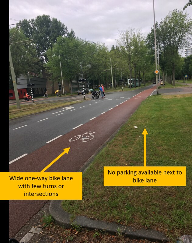
Figure 1
This bike lane in Figure 1 along Buitenhofdreef conforms to the Dutch criteria for bike lanes, as it is built along a simple 1+1 lane road with no parking allowed in this stretch. Farther down the road, parking spots were available, but since this is a low turnover area, cyclists are unlikely to be doored and are not considered to be at risk. The travel lane also appears to narrow slightly after the pedestrian crossing, which could be to lower vehicle speeds as parked cars are introduced along this stretch. The single lane prevents vehicles from passing and keeps speeds reduced for the safety of the neighboring cyclists. Despite right-angle curbs, the bike lane is wide enough to compensate for the risk of hitting the pedal against the curb, as cyclists do not have to hug the curb too closely. The lack of intersections and access roads merging onto this road allows for a straight path where cyclists may continue without stopping. While the bike lane design may not be ideal by Dutch standards, it was quite comfortable and safe to bike on.
Site 9 – Nassaulaan
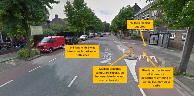
Figure 2
This street is an example of a road that was wide enough to handle two-way vehicle and bike traffic, each with its own lane. The 1+1 lane design is appropriate for this busier street, as cars may always stay in their designated lanes without crossing into bike territory, so bikes own their space completely. The parked cars on both sides present some risk of dooring, but turnover is relatively low in this mostly residential area. An interesting aspect of Figure 2 is the small median and bollard that have been added to provide temporary separation between the bike lane and the road at the location of the bus stop (on the sidewalk). This is a clever design to ensure that pedestrians will not be entering or exiting the bus directly from the bike lane, but rather will have a small buffer to queue at if necessary without blocking bike traffic. The bike lane also rises up to the same level as the median and the sidewalk, so pedestrians can cross this area seamlessly. Parking spots are not seen here, which allows space for the median to be flush with road and the bike lane to zigzag briefly out to the right.
Site 10 – Julianalaan
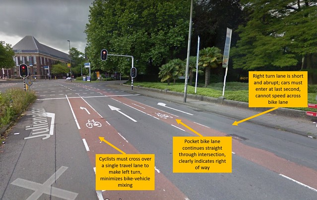
Figure 3
This intersection shown in Figure 3 along Julianalaan demonstrated the interesting concept of pocket bike lanes and left-turn bike lanes. This was confusing at first, but the logic behind the design makes sense. The one-way bike lane on the right is a continuation of the original bike lane, and continues straight through the intersection. Should the cyclist continue straight, no change in behavior is required – the cyclist still owns the lane and has clear priority over cars, and will follow the same traffic signals as the cars here. What is different about this case is that a right turn lane abruptly begins about 100 ft before the intersection. This creates a “pocket” bike lane where the cyclists continuing straight will be sandwiched between straight through traffic to their left and right-turning traffic to their right. Should the cyclist want to turn right, he/she simply moves over and mixes in with the right turn lane. The shortness of the right turn lane is important because it prevents cars from crossing the bike lane at high speeds when they enter the lane. Since they can only crossover at the last minute, they are forced to slow down and look in their mirror for oncoming bikes before crossing. Similarly, cyclists that wish to turn left must cross over the center travel lane, but can only do so when the left-turn bike lane begins about 60 ft from the intersection, at which point the center lane traffic has slowed down. Overall, this design accommodates the needs of both bikes and vehicles while minimizing possible conflicts/mixing as much as possible.
Facility Type #2: Bike Boulevards
Site 1 – Abtswoude Path, TU to Pr Beatrixlaan
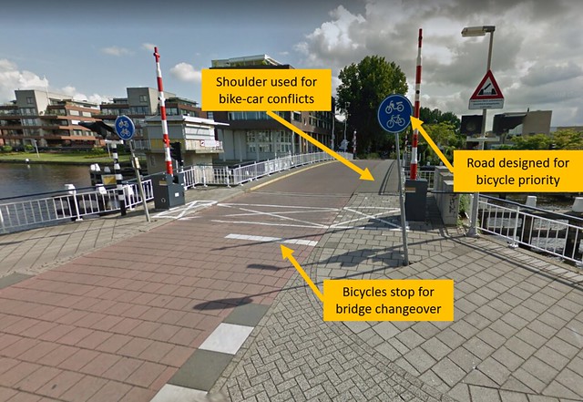
Figure 4
Some roads in Delft are used as links between service roads, cycle tracks, or other bicycle-only paths. Figure 4 shows an example of a bicycle boulevard that is designed primarily for cycle traffic, as indicated by the blue signs, but is also compatible with low-speed vehicle traffic. In this case, vehicles would be treated as “guests” on the road and would slow down appropriately to adjust to the volume of bike traffic. A shoulder area on the bridge is provided for such conflicts to give extra maneuvering space. Additionally, this spot is unique in that it marks the beginning of a bridge, which is rotated periodically to accommodate boat traffic through the canal. When we arrived, the bridge was moving and the barriers were lowered to prevent cyclists or cars from proceeding. The white stop line is also placed well before the bridge begins to give cyclists warning in advance to stop if necessary. A change in road surface from brick to asphalt also indicates the start of the bridge, and the road incline forces all traffic to slow down before crossing the bridge, whether the barriers are lowered or not.
Site 5 – Buitenwatersloot
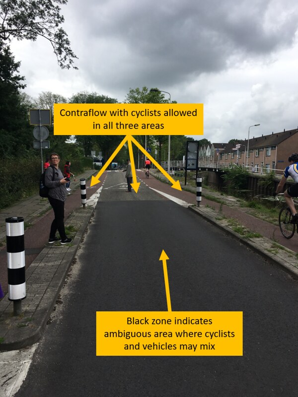
Figure 5
At Buitenwatersloot, we observed a bicycle boulevard that had been retrofitted from an old highway that ran along either side of the canal. The street is designed to cater bicycle through-traffic, as cyclists may ride in the one-way lanes on either side or in the center zone. Despite what is shown in Figure 5, we noticed that many cyclists chose to ride in the center zone since very few cars enter this area – motorists are likely to find an alternate through-route where they can drive much faster. When a car does enter, the center zone is wide enough to accommodate the car and cyclists move over to the sides. The black pavement is an indicator of an ambiguous mixing region, and the narrow medians with bollards are used as a traffic calming method to remind vehicles that their travel zone is narrow and they must respect the cyclists’ priority by not invading the side lanes. The previously existing road was wide enough to retrofit a car-friendly street design, but the planners decided that the main function of this route should be bicycle through-traffic, so cyclists have priority and may occupy the entire width of the road most of the time.
Facility Type #3: Cycle Tracks
Site 2 – Papsouwselaan
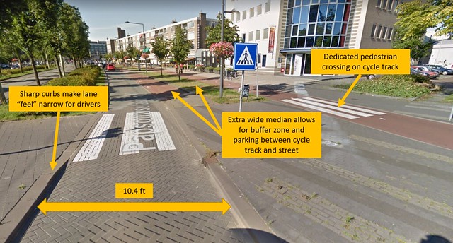
Figure 6
This site features a variety of traffic including pedestrians, cyclists, cars, and trams, so the area serves several different functions. Shown in Figure 6 is a cycle track separated from a one-lane road via a wide median. This road underwent a “road diet” to shrink down to 10.4 ft wide, with the rationale being that one lane open 100% of the time is more efficient (can carry more throughput) than two lanes each open 30-40% of the time. This site uses several traffic calming techniques such as tight curbs to make the road feel narrow for cars, particularly before the pedestrian crossing. The single lane is also self-regulating, since speeding up to pass would be impossible. Particularly interesting was the dedicated pedestrian crosswalk along the cycle track to match up horizontally with the one on the road. I had not noticed these markings on other cycle tracks we visited, which suggests that this crossing might have heavier pedestrian traffic than normal. Lastly, the extra wide median allows for ample separation between the cycle track and road, with space for both a grassy buffer and vehicle parking spots. I am not sure why the parking spots are specifically painted red, as this could be confused with the cycle track. Overall, this was one of the more interesting sites visited.
Site 3 – Voorhofdreef
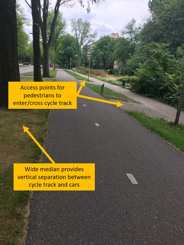
Figure 7
This 2-way cycle track shown in Figure 7 was constructed for maximum safety and comfort, and provides cyclists with peace of mind while biking through the green parkway. Not only is the grass median very wide, but the presence of tall trees evenly spaced along this long, flat route gives the feeling of biking through nature rather than an urban area. Cyclists have minimal interaction with cars, since intersections are widely spaced apart, and you can sometimes forget the road is even there. Interactions with pedestrians are also limited, as a second grassy median separates the cycle track from the sidewalk. Points of entry for pedestrians to enter or cross the cycle track are indicated with brick access paths, so cyclists can see in advance where a pedestrian may cross and. That said, the cycle track was not busy and we saw very few pedestrians on the sidewalk, so there is virtually no stress for anyone involved.
Site 8 – Ruys de Beerenbrouckstraat
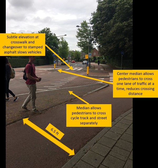
Figure 8
The Ruys de Beerenbrouckstraat is a good example of road design that allows for peaceful harmony of motorists, cyclists, and pedestrians. As shown in Figure 8, the cycle tracks are 6.5 ft wide, providing ample room for bike travel on either side of the street. This street was redesigned with the intent of vehicles traveling 40 km/hr, a reduction from the previous 50 km/hr (despite the legal speed limit remaining at 50 km/hr, the design dictated travel at 40 km/hr). Two traffic lights were removed to keep traffic flowing, but cars are forced to slow down when passing through this intersection because of the subtle road elevation at the crosswalk, the center median and bollard creating the “feel” of a narrower lane, and a changeover from asphalt to stamped asphalt, which is harder to drive on. The cycle track is separated from the road via a median that is flush with the track. There are no curbs on this cycle track, giving cyclists a greater peace of mind and the ability to let their pedal hang over the sidewalk. Pedestrians are also given crosswalks on the cycle track and street, each separated by medians so that the pedestrian only has to cross one region at a time. This is very important for safety, since the distance to cross one lane of traffic is short, then the pedestrian can wait at the island to cross the second lane (equally as short), and then can wait at the next median before finally crossing the cycle track.
Facility Type #4: Advisory Lanes
Site 6 – Hugo de Grootsraat
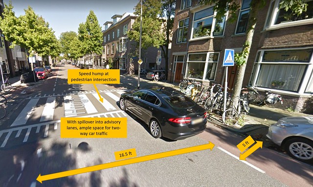
Figure 9
This street features a very wide 16.5-foot center zone with 5-foot advisory bike lanes on either side, as shown in Figure 9. The total width from curb-to-curb is thus 26.5 ft, which gives ample room for two-way vehicle traffic when cars enter the advisory lane to pass one another. With a suggested minimum of 10-foot wide travel lanes, this street presents a dilemma – it is slightly too narrow to accommodate designated bike lanes with 1+1 traffic flow, but it is also slightly too wide for its use as designed. If parking was removed from this street, there would be plenty of room for 10-foot travel lanes and separate bike lanes, or perhaps even a cycle track. However, with this street providing access to residential homes/apartments, slow speeds and accessible parking are important functions that cannot be compromised. A road diet could be considered here to shrink the road and further discourage cars from speeding. Lastly, it was interesting to see the speed hump (12 or 14 ft) at the pedestrian intersection, which continues into the advisory bike lanes as well. Thus, all traffic (car and bike) will be forced to slow down for potential pedestrians.
Site 7 – Adriaan Pauwstraat, Westplantsoen
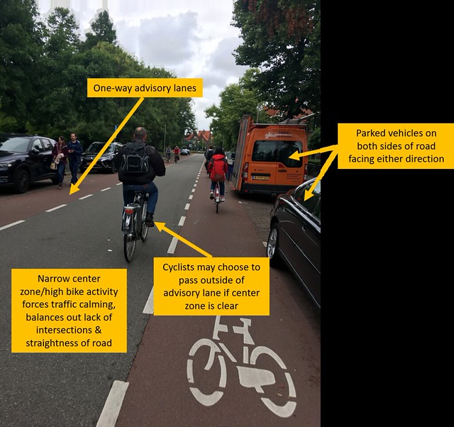
Figure 10
Contrary to Hugo de Grootstraat, Westplantsoen features a very narrow center zone, but still has 5-foot advisory lanes on either side. The need for parking on both sides restricts the width of the center zone if we must maintain the 5-foot advisory lane width. This indicates that bicycle traffic is favored over vehicle traffic on this road. Vehicles that do enter may travel both ways and park on either side of the road, but the low volume of car traffic makes this route bicycle-friendly and safe. Figure 10 even shows a cyclist preparing to pass by veering into the center zone, making this look like a bike boulevard to an outside observer. While the long, straight design of the road and lack of speed humps or intersections might encourage vehicles to speed, the narrowness of the center zone, the heightened bike activity, and the possibility of encountering a car traveling the opposite direction are all measures to keep drivers alert, reduce speeds, and maintain a desirable bike route.
Site 11 – Schimmelpenninck van der Oyeweg (Delfgauw)
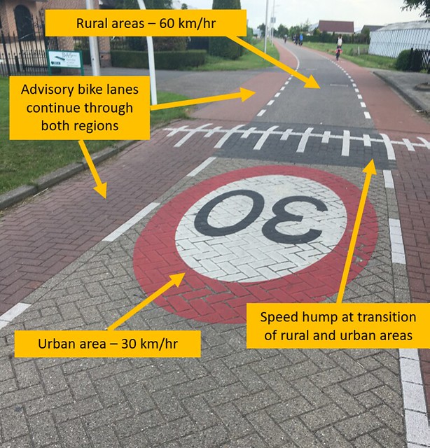
Figure 11
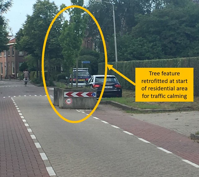
Figure 12
Figure 11 represents a unique example of advisory bike lanes that cross over between a rural and urban (residential) area. The changeover has a reduced speed limit from 60 km/hr to 30 km/hr as vehicles enter the urban area. This is marked by a large, bold circle on the urban side emphasizing the new speed limit, as well as a speed hump for self-enforcing the lower speed. Figure 12 shows a tree that was retrofitted at the start of the rural area as another traffic calming device, forcing cars to slow down. Also notable is the difference in road material (stamped asphalt vs. asphalt) as a visual boundary indicator. The road is designed such that cars may continue to use the advisory lanes as passing zones during conflicts, regardless of what area they are travelling in. Speed humps and other obstructions are removed in the rural area to accommodate higher speeds, as less conflicts are expected. This example shows how a single road can serve multiple functions through appropriate placement of traffic calming features, with little impact on bikers travelling into or out of the city.
Facility Type #5: Service Roads
Site 12 – Zuidpoldersingel (Delfgauw)
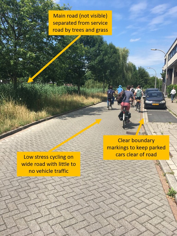
Figure 13
The service road in Figure 13 provided a peaceful, relaxing bicycle path following the same route as the main road, which is separated by a large barrier of grass and trees. This creates the allusion that as you bike along this road, you are isolated from traffic and have your own private route. Very few cars are present on this service road – I do not remember a single car passing us during our journey. With little to no motor traffic, cyclists are able to claim the whole road as their own most of the time. Parked cars are in designated spots marked with clear boundaries, and do not overlap with the main service road. This gives even more freedom to the cyclists, as they have ample width to enjoy without any obstructions.
Facility Type #6: Bicycle Highways
Site 13 – N470 Bike Highway (Delfgauw)
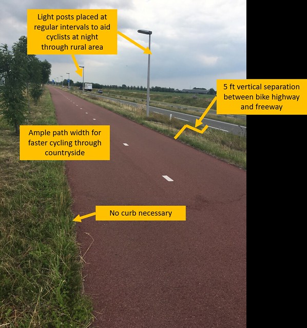
Figure 14
The bike highway shown in Figure 14 is designed entirely for low-stress bicycling through rural areas. Essentially, this functions as a less-busy cycle track with no interactions whatsoever with intersections or vehicles. The path is designed like a regular highway – smooth, flat, straight, and with no interruptions. This bike highway was built close to a freeway, but with substantial vertical and horizontal separation to ensure that cyclists are nowhere close to the fast-moving cars. The grass barrier is permeable but also so extensive that cyclists would never get close to the freeway unless they made a deliberate effort to. Curbs are also unnecessary for this path since there is no sidewalk, road, or other feature directly adjacent to the path. The path is designed very wide for cyclists to bike faster if they please, or to simply enjoy the extra space while leisurely passing through the country. Lastly, light posts are placed at regular intervals to light the path at night, as rural paths do not receive as much light as those in the city center.