
Rick Anderson, Nick Brunetto,
Justin Clark, Erin Dillmann,
Lindsey Vazquez
Background
Tremont Street dates back to the colonial era, with first documentation from 1722. Through the 18th and 19th centuries it was used as a main thoroughfare for horse and foot traffic. However, during the early 1900s Tremont underwent major changes to its design and its function. It was drastically widened to permit heavy car traffic, this is the Tremont Street we see today. Tremont Street currently functions as a main thoroughfare through Boston’s South End to main roads such as Massachusetts Avenue, Melnea Cass Boulevard, and the Massachusetts Turnpike. Tremont also provides access to the many residences and businesses that are located alongside it.
Problem
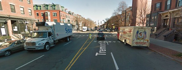
Tremont Street is currently a multi-purpose 2+2 lane road with many pedestrian crossings. Originally a 30 mph road, a recent law has changed the speed limit to 25 mph for any street without speed limit signs posted. Even with this new law being passed, the long and wide straightaways allow for vehicles to speed past each other above 25 MPH and double park in one of the travel lanes which leads to a double jeopardy situation for cyclists and pedestrians. Within the past two years there have been three casualties involving pedestrians at crosswalks, two of which have been fatal. A change needs to be made in order to make the street safer for pedestrians to cross and to reduce the speed of motor traffic.
Project Scope
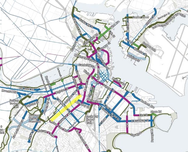
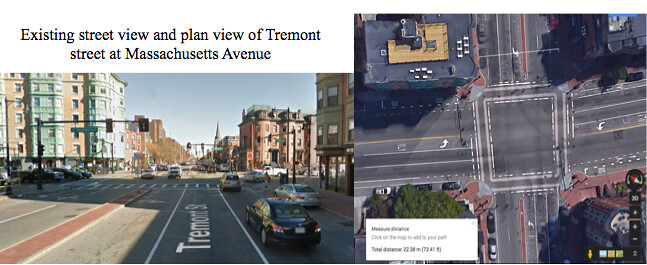
For the Tremont Street redesign, we focused on the stretch of road between Melnea Cass Boulevard and Harold Street. This area is a missing link in Boston’s proposed bike network (as highlighted in the picture below) and serves many residences and businesses.
Boston’s Bike Network Plan (Tremont St. Highlighted)
Vision and Design Objectives
The main objective for the Tremont Street redesign is to decrease road casualties for crossing pedestrians and for bicycle traffic. To reduce the number of pedestrian accidents along Tremont Street, double jeopardy situations need to be eliminated from the Tremont Street. The road will first be reduced from two lanes in each direction to one lane in each direction. Reducing the number of lanes reduces the possibility of speeding because cars cannot pass each other and reduces the possibility of double parking because there is no second travel lane to pass. At crosswalks, pedestrians will only have to cross one lane of traffic at a time instead of the four lanes in the existing design. To accommodate the large number of cross streets along Tremont Street, turning areas will be provided for left turn lanes in the intersection. There is enough space in the turning area for a car to wait for a gap in oncoming traffic without completely blocking any travel lane. At designated intersections, there will be crossing islands so that pedestrians only need to cross one lane at a time. To allow for safe bicycle facility access, one-way cycle tracks will be added to both sides of the road. Parked cars and a landscaped median will separate the cycle tracks from vehicular traffic. Cycle tracks are proposed instead of bike lanes due to the large volume of traffic on Tremont Street. The annual average daily traffic (AADT), according to MassDOT, ranges from 16,600 to 17,500.
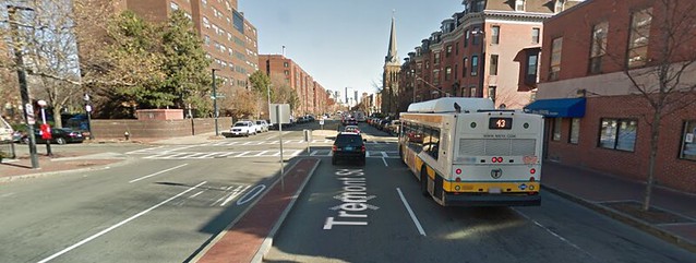
As shown in the picture below, deliveries and double parking often limit Tremont Street to one lane of travel in each direction. Because of this, reducing Tremont to one lane in each direction is feasible.
Challenges
In working to make Tremont Street more bike friendly, there are a number of challenges that arise. First, there is no existing bike infrastructure to build from. Second, Tremont street carries about 17,000 cars per day. With one lane per direction, any turn queuing at unsignalized side street intersections could result in a massive traffic backup if ample waiting space is not provided. Because of the multiple functions of Tremont Street, a third challenge is balancing the commercial and residential areas and making sure that each function is able to receive the traffic facilities that are required. For example, commercial areas need provided space for deliveries while residential areas need provided space for parking. A final challenge comes as a result of the large number of bus stops along Tremont street. Bus lanes and loading zones take up parking space and pedestrian curb space. In designing our cross-sections and intersections, the curb line along the existing sidewalk will remain intact. However, new curbs between the existing curbs and new pavement types will still be added.
Typical Roadway Cross-Section
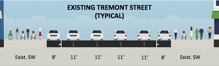
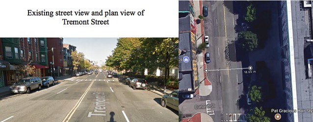
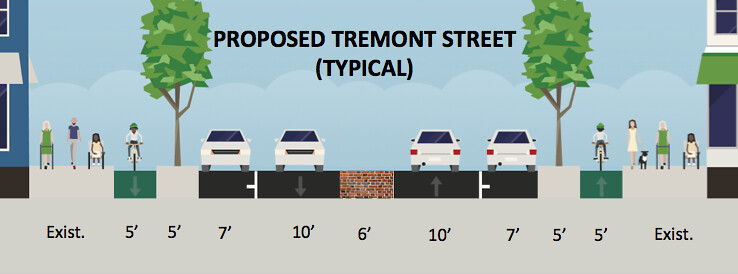
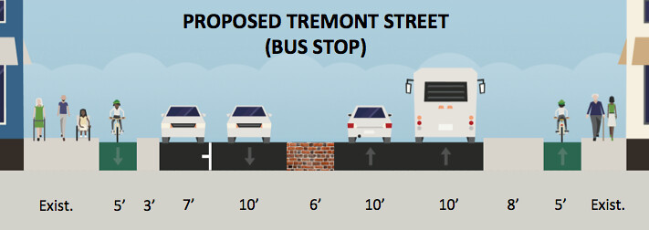
From Melnea Cass Boulevard to Herald Street, Tremont Street has a relatively constant roadway (curb to curb) width of 60 feet. Using this existing width, a one plus one (1+1) roadway design provides enough space for through traffic while limiting the opportunity for speeding and improving safety for cyclists and pedestrians. Travel lanes and parking lanes are designed to be narrow so that motorists drive at slower speeds and park closer to the curb. Only one lane is present in each direction; therefore cars are not able to pass each other, which forces them to match the speed of the car in front of them. If a delivery has to be made or the travel lane is blocked, passing can occur over the six-foot wide slightly raised brick median. However, the visual difference of the brick from the asphalt, as well as the narrowness of the brick median, will warn drivers that the median is not meant to be used as a travel lane. A wider, six-foot median is used to allow for an 18-foot width, to accommodate outriggers used by fire departments without stopping traffic in the other direction.
Outside of the travel and parking lanes, five foot wide landscaped buffers provide protection for cyclists and curb space to beautify the street. The existing condition of Tremont Street lacks green space. The addition of landscaped buffers adjacent to the cycle track and sidewalk will help Tremont appear less like a crowded, busy street and more like a bustling boulevard. The five foot wide one-way cycle tracks give cyclists a route along Tremont street that currently does not exist. Because they are located behind both a parking lane and a landscaped buffer, horizontal separated safety from motor vehicles is ensured.
Existing Conditions
Proposed Design
Inspiration for Design
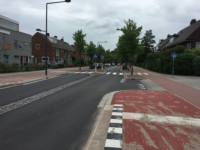
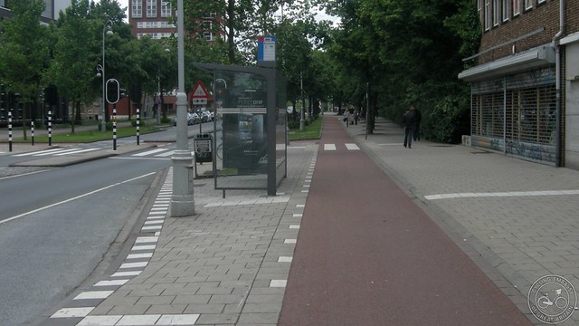
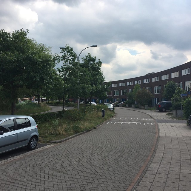
The inspiration for this design was Ruys de Beerenbrouckstraat, in Delft. The main design features taken from this street were the mountable cobble median in the center, the protected pedestrian crossings, and the physically separated cycle tracks.
Bus Stops
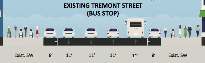
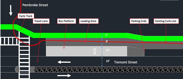
To solve the problem of backup along Tremont Street at bus stops, the designated entering and exiting bus lane cuts into the proposed parking lane to allow cars to continue to travel past the bus as passengers load and unload at the bus platform. In the existing cross section of Tremont Street, there are no designated bus unloading zones. Tremont street has two lanes in both directions (2+2); therefore, the bus would pull over in the right hand lane to load and unload into the parking lane while vehicles traveling in the same direction could comfortably pass the bus by moving into the left hand through lane. In the existing conditions picture below, this action is depicted. The redesign features the bus stop cutting into the parking lane to allow traffic to flow while the bus loads and unloads at the bus platform. The required width of the bus lane (10 feet) is 3 feet wider than the proposed parking lane. To accommodate the extra space necessary, the protected bike lane is temporarily redirected to the top of the existing sidewalk and travels around the bus platform. The redirection of the bike lane around the the bus platform allows passengers to enter the bus platform without having to cross the cycle track.
Existing Conditions
Proposed Design
Inspiration for Design
The inspiration for the bus stop came from MassDOT design guide. This design is also used at bus stops in Amsterdam.
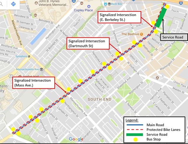
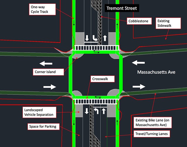
Signalized Intersections
There are five signalized intersections within the limits of the redesign, Melnea Cass at Tremont, Massachusetts Ave. at Tremont, Dartmouth St. at Tremont, E Berkeley St. at Tremont, and Harold St. at Tremont. At these signalized intersections, the protected bike lane continues but jogs away from the intersection to increase cyclists’ visibility to left-turning motorists. Intersections also feature landscaped vehicle separation and corner islands to protect cyclists from motor vehicles, while a left turn lane is added to maintain vehicle throughput. As the road approaches one of the three major signalized intersections, the median narrows and creates space for a 10 foot left turn lane. At intersections such as at Massachusetts Avenue and Tremont Street (used as an example for the proposed design), left turn lanes are necessary to prevent backup on Tremont Street if several drivers want to turn left, a highly likely outcome because Tremont Street’s AADT ranges from 16,600 to 17,500. If the left turns lanes are not present, backup is likely because drivers would be forced to line up along the through lane, preventing drivers from traveling straight through. Unlike the unsignalized intersection, a center crossing island is unnecessary because the pedestrian crossing is signalized.
In addition, the intersection design is safer for cyclists because the corner islands and landscaped vehicle separation provide increased visibility for cyclists and force motorists to travel slowly through the intersection. Although parked cars add separation between cyclists and motor vehicles, they detract from cyclists’ visibility, especially at intersections. To correct this feature, parking will end well before the intersection by installing a landscaped vehicle separation area to prevent cars from parking too close to the intersection. This concrete area will allow cyclists to see cars traveling perpendicular to them, and vice versa. With both cars and cyclists being able to see each other at the intersection, conflicts can be avoided. The corner islands at the intersections also increase safety because they require cars to make a sharper turn, slowing them down through the intersection. Both of these features add safety to the pedestrian crossings because they allow the pedestrian to travel further into the intersection without conflicting with cars, shortening their interaction with them.
Existing Conditions
Proposed Design
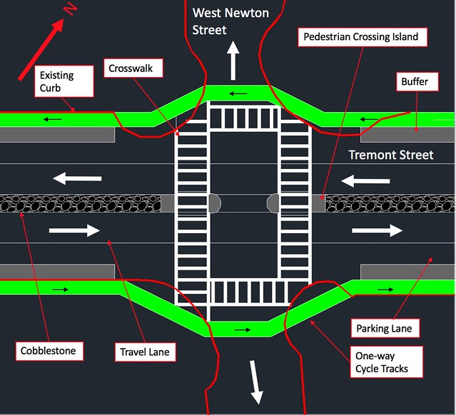
Unsignalized Intersection
The many unsignalized intersections feature a pedestrian refuge area in the middle of the crosswalk to add additional protection to crossing pedestrians. This area allows pedestrians to cross only one lane at a time, adding to their safety because they only need to watch one lane of travel at a time. In addition, these crossings are safer for cyclists because the cycle tracks curve away from the road, reducing the risk of conflict with right turning vehicles. When the cycle track curves away from the through lane, more time is given to cyclists and motorists to make eye contact to avoid each other. Unlike the signalized intersections, there are a fewer amount of cars turning left, rendering protected left turns unnecessary. Cars that want to turn left can pull into the central space to wait for a gap in traffic to turn left to allow traffic flow to continue as usual. Since fewer cars will be turning left at these less busy intersections, backup will not likely occur due to the lack of a left turn lane.
Proposed Design
Inspiration for Design
The cycle track intersection design was inspired by one of Mark Wagenbuur’s videos. The cycle track curves away from traffic, preventing conflicts with right turning vehicles.
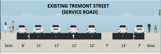
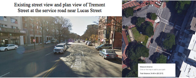
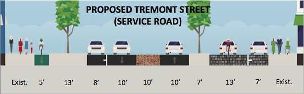
Service Road
Between the E Berkeley Street intersection and the Herald Street intersection, shops along the east side of Tremont are provided access through the use of a service road. In the new design of Tremont Street, along the service road, the cycle track will disappear on the east side of the street and the service road will be used as a shared road for both cyclists and motorists. To avoid cut-through traffic, the road will be resurfaced to stamped asphalt to signal to drivers that they are entering a mixed-use zone. Additionally, the speed of the motorists will be controlled in the service lane using speed humps. This will force drivers to travel slowly while in the service road, but will not affect cyclists. The shops along this road will still receive parking and deliveries via the service road.
Existing Conditions
Proposed Conditions
Inspiration for Design
The service road design came from Zuidpoldersingel in Delfgauw. The road features stamped asphalt to indicate to drivers to travel slowly through the neighborhood, as well as speed humps to reduce drivers’ speeds.
Reflection
Our group learned the importance of being detail oriented. At first, a central median was included in our design in order to create the 1 + 1 lane road. There are many side streets along Tremont in which residents would be attempting to turn on to, so we needed too many breaks in our medians for the cars to be able to make these turns. After further review, it was found that trucks making deliveries outside of the designated times would block all traffic flow in that direction. To accommodate passing under these circumstances, the curbed median was replaced with a narrower cobblestone median. Without thinking critically about different scenarios, this circumstance may have been missed.
Sources
https://www.google.nl/search?q=sidewalk+bulb+design+for+cycle+tracks&source=lnms&tbm=isch&sa=X&ved=0ahUKEwi-96as5P_UAhXJKlAKHUJCACcQ_AUICigB&biw=1280&bih=609#imgrc=dyuG5VUAMqOXbM
https://www.wired.com/2014/06/a-new-bike-lane-design-that-could-make-biking-more-popular-and-save-lives/
http://www.massdot.state.ma.us/highway/trafficvolumecounts.aspx