
Tremont Street Redesign
Alison Lunny, Ethan Rice, Hector Santiago, Ramzi Talhouk, Jonathan Zoccoli
I. Problem
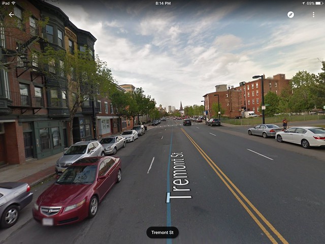
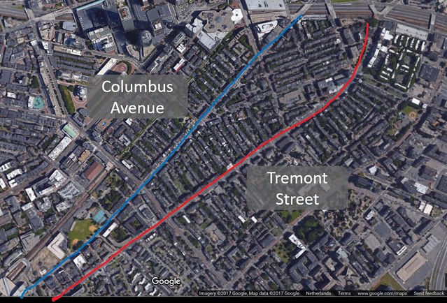
Two years, two deaths. The track record for Tremont Street in the South End of Boston speaks volumes to the traffic safety in the city. Tremont Street is designed with two lanes on each side, and cars are encouraged to drive faster (pictured below) than the posted 25 mph speed limit. This encourages drivers to speed, which can cause problems for bicycles and pedestrians at crosswalks. Furthermore, Tremont Street has a parallel street, Columbus Avenue, that, based on empirical evidence, has less traffic than Tremont for no reason other than Tremont’s two lane design and faster speeds. If Tremont could be slowed down and better accommodate pedestrians and bicycles, it is possible traffic would balance out between the two streets, making Tremont even safer and likely barely affecting Columbus Ave.
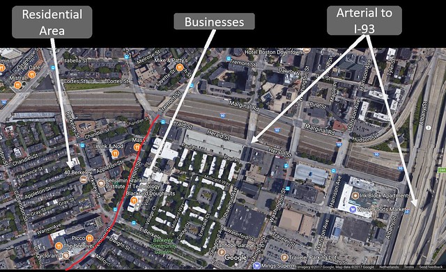
Pedestrians are constantly crossing Tremont street since it is surrounded by residential areas and businesses. The functions are utterly incompatible. There is no denying that fact. As seen in the picture below, Tremont street is long and wide making it completely unsafe for pedestrians. Crossing 4 lanes at a time is not acceptable. Cars cannot see pedestrians all the time. For example If a person starts crossing Tremont the first car may see him but then the other lane is blocked by the first car making the pedestrian invisible. This is called double jeopardy and it has been a major cause of pedestrian injuries and deaths. Since Tremont is a four lane road then there are even more chances that this could happen. On top of that since Tremont is long and straight, inviting cars to speed while increasing accidents and fatalities.
II. Background
Tremont is classified as a “full access minor arterial” by the Massachusetts Department of Transportation (a.k.a. MassDOT). According to MassDOT, this classification means that Tremont provides “important connections between the principal arterial and collector network in urban areas.” With this classification comes unfavorable road conditions for bicycles and pedestrians. There have been two recent pedestrian deaths on the road. In November of 2015, two women were hit crossing the road; one died, while the other sustained serious injuries (“South End residents…”). After this incident and many others like it, in addition to residents’ complaints of speeding cars, Boston reduced the default speed limit of roads like Tremont from 30 miles per hour to 25 mph (Gans). While this seems to be an appropriate speed limit for such roads, the design has not changed to make the speed limit self-enforcing. This was unfortunately demonstrated on May 30, 2017, when another pedestrian casualty occurred. A man carrying groceries was hit and killed by a car as he was crossing Tremont (Planas). In fact, this incident spurred an article in NBC Boston, published on July 11, 2017, shedding light on the danger to pedestrians on Tremont and other streets like it. It is becoming more apparent that a redesign of Tremont is blatantly necessary.
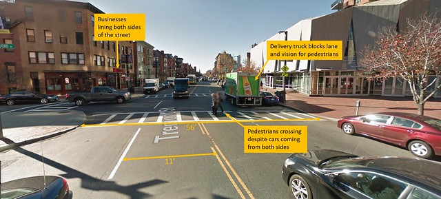
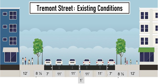
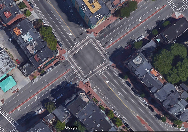
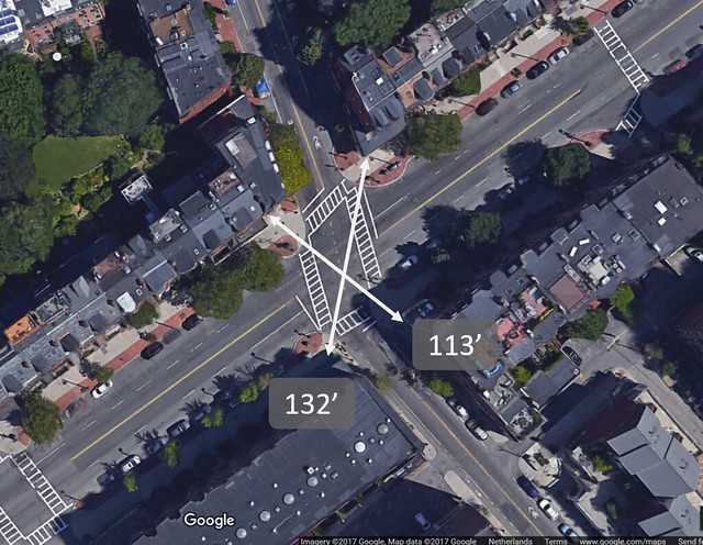
Today, Tremont is a 2+2 lane road with eleven-foot travel lanes. Pictured above is the intersection of Tremont and Milford Streets. This intersection shown above is a very good illustration of how many incompatible functions Tremont Street has. Firstly, the street is lined with businesses on both sides, each with housing above them. In fact, on the right of this photo is the restaurant Barcelona, which is one of the more highly-rated restaurant in the city. Due to the existence of businesses, customers frequently want to cross the street to walk to their home or to where they have parked. Two pedestrians can be seen doing exactly that in the photo above. The only help for pedestrians who are looking to cross the street is a fifty six-foot zebra crosswalk, forcing the pedestrians to cross four lanes at once. This leads to pedestrians putting themselves in danger, often crossing with cars headed right for them, as seen above. Additionally, a delivery truck is pulled to the side of the road, both blocking a travel lane and obstructing the view of pedestrians trying to cross the road. One road should not have all of these incompatible functions; it is very difficult to support a road with through traffic, business (which must receive deliveries), and residential buildings (which must have adequate parking to accommodate residents).
Tremont is currently referred to as a secondary bike route in the 2013 Boston Bike Network Plan, with the nearby primary bike routes being Columbus Avenue, Melnea Cass Boulevard, and Shawmut Avenue. However, Columbus Avenue only has traditional bike lanes (which are not the safest form of bike infrastructure), and Shawmut has no biking facilities to date. Tremont Street is trying to perform two different functions that are incompatible with each other. We propose that we make it more like a local road, as Tremont is in the highly residential South End, which has many driveways and smaller neighborhood streets within it. We would like to follow the “build it and they will come” mentality for these residents because if we force cars to actually drive 25 miles per hour and provide cycling facilities, then nothing will be standing in the way of residents to bike.
III. Design Goals
The primary goal of the design is to make Tremont Street a safe, 8 80 street. An 8 80 street means that it will be safe for people from ages 8 to 80. We want it to be an 8 80 street because as mentioned previously, there are a lot of residents of all ages in the area who will need to get around their neighborhood. Two deaths and one major injury is completely unacceptable for any street, let alone a street neighboring homes. The city of Boston needs to make the street safe for non-vehicle travelers so that no more blood is spilled on Tremont.
To make sure the speed limit of 25 miles per hour is upheld the lanes will be changed from two lanes in each direction to one lane in each direction. The lanes will also be narrowed from 11 feet to 10 feet in width. This road diet can be justified for three main reasons. The first is that, on Tremont, it is quite common to see cars double parked, blocking one lane and essentially making Tremont a one-lane road anyway (this can be seen in the previous photo as a delivery truck blocks the right lane in one direction). The second reason is that even when cars are not double parked, 2+2 lane roads are often blocked in their left-hand lanes by cars waiting to cross oncoming traffic to turn left. Therefore, the road can usually carry just as much volume in one lane if space is provided through traffic to get around left-turning cars. The third and final justification for Tremont’s road diet has to do with Boston’s street network as a whole. Tremont Street as it is right now carries a lot of traffic while Columbus Avenue, a neighboring street, is a relatively quiet and more local street. The two run parallel to each other and if we were to even the traffic between the two, not only would it be safer for bicycles and pedestrians on Tremont, but it would not be that much more unsafe on Columbus due to its established infrastructure. This plan is based on the assumption that two medium-traffic roads are safer than one high-traffic and one low-traffic roads. Our vision for Boston’s street network is to make Tremont and Columbus sister streets, and aim to do this by making Tremont more inconvenient to drive on. By no means, however, is our goal to simply move traffic from Tremont to Columbus and displace the problem. Instead, we believe that Tremont and Columbus serve very similar functions, and we would like to redesign Tremont to reflect that.
IV. Design Details
Street Design:
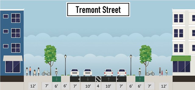
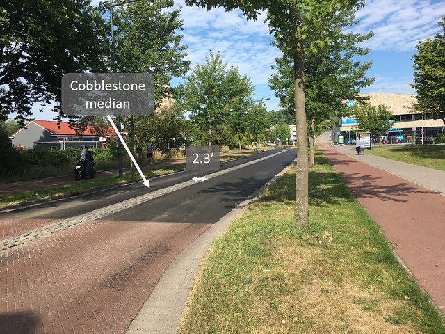
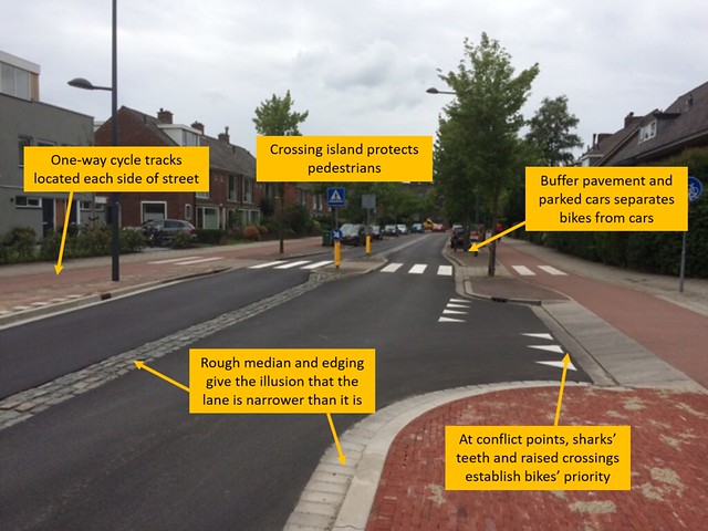
Above is a StreetMix diagram of the proposed new design of Tremont Street. The core of the design is a standard road diet, in which a 2+2 lane road is reduced to a 1+1 lane road with bicycle facilities. This is exactly what can be seen in the diagram. Two ten-foot travel lanes give cars ample room to drive, without giving them enough room to comfortably speed. Also proposed in the driving space is a four-foot cobblestone median that would make the lanes feel smaller than they are (similar to Ruys de Berenbrouckstraat—a.k.a. Ruys de B-straat—in Delft, pictured below). The median also gives cars space to move partially out of the travel lane should they need to turn left and allows wider vehicles to drive on it. In total, the proposed re-design of Tremont Street narrows the roadway by twenty-one feet, which means the wide sidewalks can be maintained, and bicycle infrastructure can be added. Outside of the driving space there is a six-foot buffer that includes street lights, which provide both extra vertical separation between bikers and car drivers, and light to both the road and the cycle tracks. Wide, one-way cycle tracks appear on both sides of the street and allow for side-by-side riding or passing. Due to the space gained from the driving area, there is also room for twelve-foot sidewalks, trees and bicycle parking.
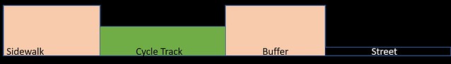
Vertical dimensions must also be considered when designing streets, especially when cycle tracks with vertical separation must be taken into account. The standard curb height in Boston, according to Jeff Rosenblum, former urban planner for Cambridge, MA, is four inches, so we will continue that standard. Vertical separation between bicycles and pedestrians is also desirable, so the proposed cycle tracks on Tremont Street will lay two inches below the sidewalk and two inches above the street (see figure below). This makes each mode of transportation on its own level and makes it easier to have raised crossings at intersections.
Massachusetts Avenue Intersection:
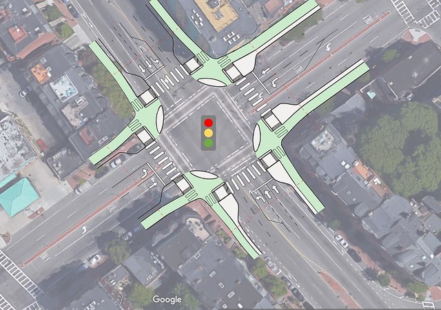
For the intersection of Massachusetts Avenue and Tremont Street, we decided on the design of a signalised protected intersection. Currently, this intersection has an excessive amount of pavement. This excess pavement means larger crossing distances and lane widths, making vehicular collisions more probable. With the new intersection, that space will be minimized by tightening lane widths, eliminating unnecessary travel lanes and making space for cycle tracks. Additionally, the intersection will be raised to sidewalk level to give handicapped persons a safer crossing, while also slowing cars down as they cross through the intersection. Below, a Dutch example is shown. Dashed lines in the intersection, seen below, are not incorporated in the new Massachusetts Avenue intersection, as crossing distances are minimized and signalized at all times, reducing chaos. Another key feature of protected intersections is the corner island. These make the turns sharper so cars slow down, while creating a perpendicular crossing with the cycle tracks and pedestrian crosswalks. As for signalization, people riding bikes and pedestrians will cross at the same time, and cars will cross separately, to reduce the risk of a casualty-inducing collision.
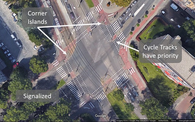
A Dutch example of this is an intersection we visited in Rijsveijk at Burgemeester Eslenlaan, Generaal Spoorlaan, and Hendrik Ravesteijnplein (shown above). When riding and crossing the intersection, it felt safe and like we, bikers, were separate from traffic. We want this same feeling crossing Tremont, which was why we chose this design.
This intersection design will also be used for the Berkeley Street intersection. However it will be on a smaller scale since it is smaller than Massachusetts Avenue. Another distinction is that from south to north Berkeley is a three laned one way street and from north to south it is a 2 + 2 street, so signals will be adjusted accordingly. This intersection will not be raised, unlike Massachusetts Avenue since it is smaller.
Melnea Cass Boulevard Intersection:
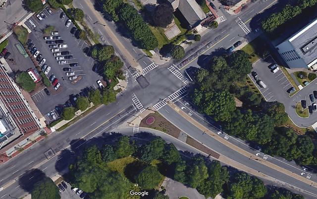
The Melnea Cass Boulevard Intersection with Tremont Street experiences high traffic volumes at peak times, as Melnea Cass is a connector road to Interstate 93. The intersection is currently signalized for vehicles and pedestrian crossings. Despite signalization, the intersection remains daunting and less safe than it should be. This is because crossing Tremont Street here means to cross 60 feet of asphalt in a limited signal cycle. This causes a disconnect between pedestrians’ perceived safety while crossing the intersection versus the actual safety while crossing the intersection. Signalized intersections are safe for pedestrians, but some cars make right turns on reds and enter crosswalks that are supposed to be signalized and protected. The current intersection design also allows vehicles to meet pedestrian and cyclist street crossings at angles that are unsafe. The safest way for vehicles to intersect with cyclist and pedestrian crossings are at 90 degree, perpendicular angles, as this provides the maximum visibility of cyclists and pedestrians to drivers.
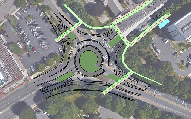
We are proposing a roundabout, which not only allows pedestrians and bikers to cross one travel lane at a time, but also requires vehicles to cross at perpendicular angles with the cycle tracks and pedestrian crosswalks. Each travel lane approaches and leaves the roundabout with medians or curb edges on either side. These are used as refuge islands for pedestrians and cyclists, making them cross one travel lane at a time, which is safer than trying to find a gap in moving, multi-lane traffic.
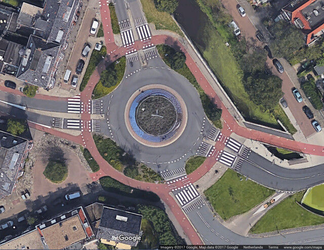
This new roundabout will also be a “Knee Roundabout”, since there is a heavy traffic from south to west and vice versa. The knee roundabout serves as a two lane roundabout while still keeping the bypass that goes from Tremont to Melnea Cass, and provide a smooth transition from 2+2 Tremont Street to 1+1 Tremont Street. The bypass to Melnea Cass Boulevard will also have a tighter turn radius and take up less space to ensure that cars go slow, and are thus more aware of upcoming pedestrian and cyclist crossings. In the existing intersection design, the bus stop (shown above in blue) is shared with the parking lane, and is very close to the edge of the intersection. Buses are large vehicles and block sight lines from drivers to pedestrians and cyclists, and vice versa. That’s why for the redesign, the bus stop is shifted farther away from the intersection, and given a loading bay within the parking lane. This makes crosswalks visible to drivers and keeps the one travel lane unblocked by a stopped bus.
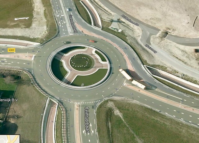
Below is an example of a Dutch knee roundabout on Harderwijkerweg in Ermelo (pictured below). Although there are no buffers or dividers in between the lanes inside the roundabout, there are signs on the road before entering the roundabout that show where cars should be in order to reach a desired direction. In this design, the cycle track was built below the roundabout, making it safer for cyclists. The reason why we aren’t designing a cycle track below the Melnea Cass roundabout is because we assume it can support crossing bike traffic if it already supports crossing pedestrian traffic, and it is more costly to install such a roundabout. The safety argument of roundabouts to traditional signalized intersections checks out in the Netherlands: where roundabouts were installed, crashes decreased by 60% and injuries decreased by 80% (Furth).
Dartmouth Street Intersection:
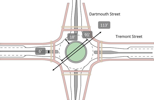
A roundabout at the intersection of Dartmouth Street and Tremont Street was part of the redesign of Tremont Street in order to increase pedestrian and cyclist safety. Essentially, the street safety principles applied to the Melnea Cass Boulevard intersection, apply to Dartmouth Street intersection, although at a smaller scale. This intersection is one of the only places where a 1+1 local street crosses Tremont Street, as the majority of the other intersections involve one way streets. The existing intersection is signalized, so pedestrians have their own signal. However, signalization fails to address the issue of vehicular right turns on red. These types of turns are supposed to be illegal in Boston, but the rule is rarely enforced. The roundabout keeps pedestrians and cyclists safe even in the face of right turn on reds because vehicles must now yield to the cyclists and pedestrian crossings, which will be indicated using shark teeth (painted triangles pointed to the party that should yield). Additionally, there is a median between travel lanes on the edge of the roundabout, which serve as pedestrian and cyclist islands. This means that pedestrians and cyclists only have to cross one lane of vehicle traffic at a time, which is manageable for the most vulnerable: young children and the elderly. This results in less stress for all users, as vehicles know to watch and yield to cyclists and pedestrians.
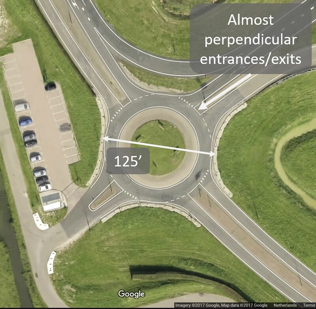
A few Dutch examples of single lane roundabouts are the intersections of Nassaulaan, Delftgausweg, Rijksstraatweg, and N473 in Delft and the intersection of N478 and Klaas Engelbrechtsweg just outside of the city (shown below, respectively). Our Dartmouth street intersection is similar in radius and number of entrances/exits to N478 and Klaas Engelbrechtsweg but includes a cycle track like Nassaulaan, etc. Our design not only fits into the Dartmouth-Tremont intersection, but there will be leftover space on the corners so we can hold a larger pedestrian queue.
Unsignalized Intersections:
Along Tremont Street between Melnea Cass Boulevard and Herald Street there are several small intersections that connect Tremont to South End residential streets. Many of these residential street are one-way, and often change their direction once they get to Tremont (either converging towards or diverging away from Tremont). After some careful consideration, it was decided that these intersections will be split into two categories: major unsignalized and minor unsignalized. Every intersection within each category will have the same design under the proposed plan. Both designs are again inspired by Ruys de Berenbrouckstraat (pictured above) and therefore have many similar features.
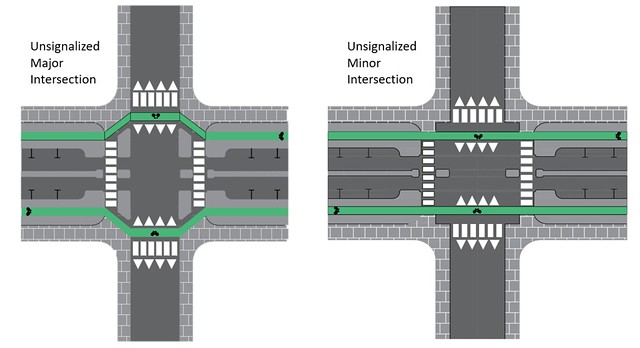
Pictured above and to the left is an AutoCAD representation of a proposed unsignalized major intersection. This type of intersection is designed for cross streets such as Hammond, Northampton, and West Newton Streets and Union Park. There are a few main design features of this intersection to highlight. The first is the widening of the central median from four feet to six feet, thereby allowing the creation of a non-mountable crossing island. This also narrows the travel lanes to nine and a half feet, which will contribute to traffic calming at the intersection. Also to be installed are four islands on the corners of the intersection, which both forces the cycle track further onto the cross street and slows down turning cars. This ensures that cars will meet bicycle and pedestrian traffic and at a ninety-degree angle and at low speeds. Also proposed for this intersection are raised crossings, which further reduces dangerous conflict between cars and other forms of traffic.
Pictured above and to the left is the representation of a minor unsignalized intersection. These intersections will be implemented at the many places Tremont intersects with small, local, residential streets in Boston’s South End. Like the major unsignalized intersections, these minor ones feature the same widening of the median, narrowing of the travel lane, and raised crossings. However, they do not have any corner islands, nor do the cycle tracks have any turns. These treatments were deemed unnecessary for the minor intersections due to the low volume of cars on the cross streets, and the low speed at which cars travel on local streets in the South End. Additionally, costs can be reduced if said treatments are omitted on minor intersections.
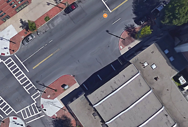
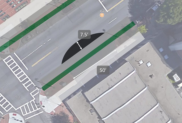
Boston Fire Department:
An unusual aspect of Tremont Street is that it has a fire station on it. To deal with this, we will take out the grass divider between the bike track and road, the median, and car parking lane for the 50 foot width the entrance/exit takes up and install a 7.5’ curved apron (4.44% grade) to ensure fire trucks can easily exit the station.
V. Reflection and Conclusion
There is so much potential for roads in the United States to emulate those found in cycle-friendly countries like the Netherlands and Denmark. The roadways are certainly wide enough and as one of the most powerful nations in the world, we certainly have the engineers to design better infrastructure and the labor to build it. Yet there are still so few cities that have embraced ‘All But Car’ (ABC) travel. Coming to the Netherlands to study has shown us that it is not terribly difficult to drastically improve certain streets in American cities. After only two weeks of studying sustainable urban transportation, Northeastern and
Portland State University students have come up with redesigns to improve and handful of Boston and Portland city streets.
That being said, redesigning one street is not enough. Studying transportation in the Netherlands has given Team Shut Up a greater appreciation for all the factors that must be considered when designing a road network. A change on one street can have repercussions on neighboring streets and/or neighborhoods. Consequently, while designing a single street may not be in itself extremely difficult, overhauling an entire urban road network—which has been shown to be necessary if ABC travel is to be truly ubiquitous—is more difficult. Moreover, the transition to ABC will likely be even harder in the United States due to its history of endorsing vehicular cycling theory and similar schools of thought. However, there are steps being taken to turn this around and if the culture in the United States were to change, it has the potential to pay dividends for our public health, happiness, and carbon footprint.
Success is made up of a series of small steps, however, and this redesign of Tremont is no doubt one small step in changing the culture of transportation in Boston. If this design of Tremont street were to be implemented, it is highly likely that traffic would slow in speed and lessen in volume, pedestrians would be safer, and bicycle traffic would increase. It would also serve as an example to the rest of Boston of what can be achieved on the existing city streets.
References
Boston Bike Network Plan [PDF]. (2013). Boston: Boston Department of Transportation.
Building the Protected Intersection [PDF]. (2015, December). Portland: Alta Planning Design.
“Definition of Functional Classification.” MassDOT. Massachusetts Department of Transportation, 2017. Web. 10 July 2017.
Furth, P. (2017, July 5). Systematic Safety. Lecture presented in Netherlands, Delft.
Gans, F. (2017, January 8). Boston’s 25 mile-per-hour default speed limit takes effect Monday. Boston Globe.
Planas, A. (2017, May 30). Pedestrian killed in South End accident. Boston Herald.
South End residents raise concerns after pedestrians hit. (2015, November 5). Fox 25 Boston.