
Design Project 2: Tremont St. Redux
Alison Lunny, Ethan Rice, Hector Santiago, Ramzi Talhouk, Jonathan Zoccoli
I. Problem
In the past two years, there have been two pedestrians killed on Tremont Street in the South End neighborhood of Boston, MA. Today, Tremont is trying to serve too many incompatible functions. It is in a residential area and lined with businesses, meaning delivery trucks are double parked up and down the street and pedestrians need to cross frequently. Nevertheless, through traffic speeds up and down Tremont trying to get to and from Downtown Boston on a road that is classified as a minor arterial and has two travel lanes in each direction.
II. Functionality
Tremont wasn’t designed to be a main through road, which is why it seems too large and incompatible with the businesses and residences that line it. As Boston grew, Tremont was forced to fit more and more cars without any major redesigns. To learn more about the history of Tremont Street, click here.
Current
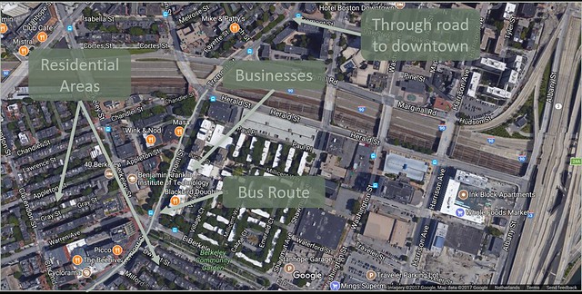
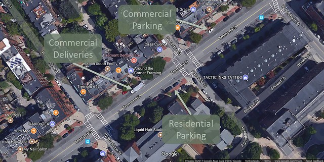
Figure 1: Bird’s-eye illustration of incompatible functions on Tremont Street
Tremont Street carries out many functions. As shown in Figures 1a and 1b above, it is a neighborhood collector road, a street with businesses attracting deliveries and customers, a bus route, a large provider of residential and commercial parking, and an arterial road connecting to Downtown Boston. It is very difficult for a street to serve all these purposes well, and Tremont is proof of that. Since it is located in the middle of the South End, Tremont cannot serve as a barrier and must provide adequate and safe means for pedestrians to cross the street, provide bike facilities, and be a place where people want to live. All of these functions are compatible, as long as Tremont does not continue to be an attractive route for through traffic to and from Downtown Boston.
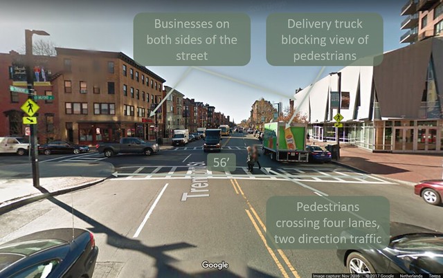
Figure 2: Hazardous crossing on Tremont Street
Pedestrians are constantly crossing Tremont Street since it is surrounded by residential areas and businesses. However, due to its through road functionality, Tremont Street is long and wide making it completely unsafe for pedestrians (see picture above). The only infrastructure for pedestrians crossing four lanes is a 56-foot wide sidewalk, which can be seen in Figure 2 above. Cars cannot see pedestrians all the time. For example, the two pedestrians seen crossing Tremont in the photo above were, just prior to the capturing of the photo, were behind the delivery truck double parked on the right. This would have made them invisible to any vehicles traveling in the opposite direction (toward the photographer). This phenomenon is called double jeopardy and it is a major cause of pedestrian injuries and deaths. Tremont’s wide, four lane, and straight design encourages cars to speed and pass, further decreasing the reaction time and stopping distance of a car about to hit a pedestrian.
There have been two recent pedestrian deaths on the road. In November of 2015, two women were hit crossing the road; one died, while the other sustained serious injuries (“South End residents…”). After this incident and many others like it, in addition to residents’ complaints of speeding cars, Boston reduced the default speed limit of roads like Tremont from 30 miles per hour to 25 mph (Gans). While this seems to be an appropriate speed limit for such roads, the design has not changed to make the speed limit self-enforcing. This was unfortunately demonstrated on May 30, 2017, when another pedestrian casualty occurred. A man carrying groceries was hit and killed by a car as he was crossing Tremont (Planas). In fact, this incident spurred an article in NBC Boston, published on July 11, 2017, shedding light on the danger to pedestrians on Tremont and other streets like it. It is becoming more apparent that a redesign of Tremont to fit it’s main functions is blatantly necessary.
Functional Vision
Tremont Street will be able to serve all of its current functions, except that which makes it a through road. As shown below in Figure 3, Tremont Street (highlighted in light green) runs through the middle of the South End neighborhood of Boston. It doesn’t make sense for this neighborhood to be split into two by a through street with residences on both sides. The functionality of the new Tremont Street will be to promote local transportation (walk, bike, bus), provide parking for residents and businesses, and provide loading zones.
Ideally, Tremont Street will feel like a neighborhood collector street, a slight demotion from its current status. Many similar demotions have been made in the Netherlands, most notably Ruys de Beerenbrouckstraat in Delft. Ruys de Beerenbrouckstraat used to be a road similar to the current Tremont, but was turned into a more neighborhood friendly place, and the design changes alone changed the average speed on the road from 33 mph to 26. To learn more about this transformation, click here.
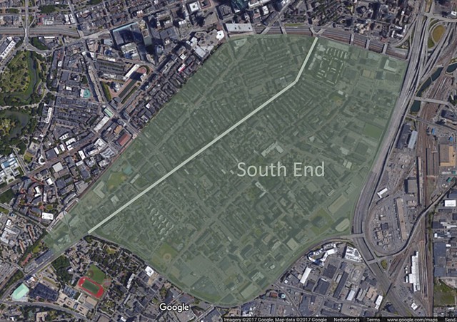
Figure 3: Illustration of the division of Boston’s South End by Tremont Street
Network
As can be learned from Dutch urban planning techniques, no design for a road is complete without careful consideration for how the new designs will affect a city’s street network as a whole. As mentioned, Tremont Street is a minor arterial that connects parts of Brookline, Roxbury, and the South End to Downtown Boston. As a result, there is a considerable amount of through traffic on the South End portion of Tremont. This is incompatible with the ideal functions of Tremont, which are to be a small neighborhood collector and a local business street for South End residents.
The South End of Boston has several high-volume streets that connect it to downtown Boston: Columbus, Tremont, Washington, Shawmut, etc. Therefore, no singular street is responsible for carrying all of the South End’s through traffic; it is instead distributed between them. Figure 4 below is a map illustrating this concept. Each shaded area represents the approximate area that each corresponding through-street services. None of the individual areas are very large and are therefore not responsible for a lot of through traffic on their own.
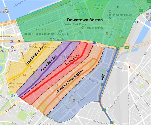
Figure 4: Map illustrating the ares serviced by major streets in Boston’s South End
The reason for Tremont’s congestion then, is likely that many car drivers in surrounding neighborhoods are using it as their main arterial to and from Downtown. Figure 5 below is another map, showing the likely collection area of Tremont as it starts to leave the center of Boston. This area is much larger than the area through the South End and is therefore likely responsible for much more of the through traffic that exists on Tremont today.
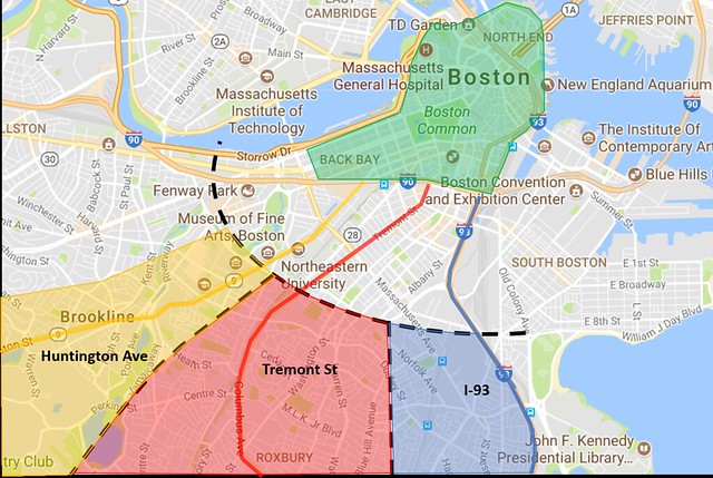
Figure 5: Residential areas serviced by streets connecting to Downtown Boston through the South End
Therefore, if Tremont is to be demoted in the proposed fashion, the residents living in the red shaded area above will need a new route to get into the center of the city quickly. Fortunately, such a route is already built. Melnea Cass Boulevard was build in the early 1980s for the exact purpose of providing a route directly from the South End to the Interstate 93. This route serves as a great alternate route for through traffic to and from Downtown Boston after Tremont’s demotion. Figure 6 below is a map of the route, which shows the Tremont-served area of Roxbury shift to an area serviced by the Interstate 93, and shows the new Tremont serving predominantly its local neighborhood, as it should.
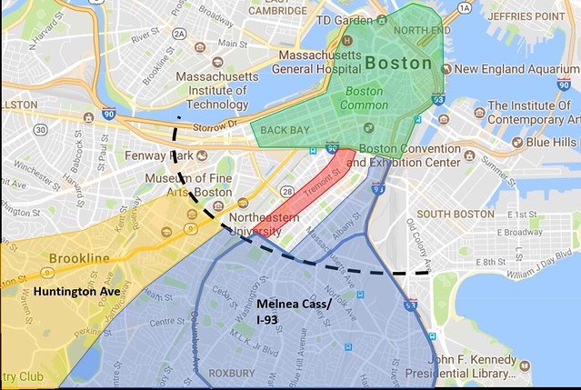
Figure 6: Revised network plan to connect Roxbury to Downtown Boston by using Melnea Cass bypass to I-93
Keeping through traffic on larger flow roads and ring roads and off of neighborhood streets is a concept widely applied in the Netherlands. Even the small, old city of Delft has a clever design that uses an existing street network to accomplish this purpose. Figure 7 below is a map of Delft. It’s ring road is outlined in black, and the green and blue overlays indicate separate neighborhood compartments. Each compartment channels traffic toward the ring road and away from the city center (as indicated by the arrows). Both the Melnea Cass bypass and street grids in cities like Delft should prove to Boston and other cities in the United States that such principles can be applied no matter the existing street grid, and that applying such principles can lead to more livable streets in cities.
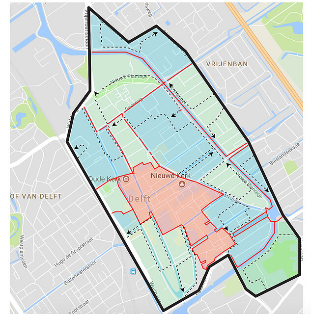
Figure 7: Map of Downtown Delft, Netherlands that illustrates how traffic is directed to through roads and kept off of neighborhood streets
To learn more about how Delft keeps its city center car light, click here.
A good network for car drivers is not the only kind of network that needs to be taken into consideration. The Dutch are masters at creating good bike networks, and it shows: currently, 26% of all trips are taken by bike in the Netherlands. Their secret is creating a full network of safe and low stress bike routes, making it easy for cyclists to get from anywhere to anywhere. The proposed design of Tremont will greatly increase the connectivity of Boston’s bike network. Currently, Boston had two good bike routes that flank each side of Tremont’s South End portion. The first is the Southwest Corridor that follows the Orange Line of Boston’s underground rail service. This route connects a significant portion of Boston’s more residential areas, like Brookline and Roxbury, to the South End. On the other side of Tremont is the Chandler-Charles route, which follows Charles street through Downtown Boston, Boston Common, and nearly connects to the Longfellow Bridge to Cambridge. If Tremont Street’s bike facilities are improved to the standard proposed, it would serve as an ideal connection between the Southwest corridor and Chandler-Charles route. Figure 8 below is a map of the proposed unbroken cycle route, providing a smooth commuter route in and out of the center of Boston.
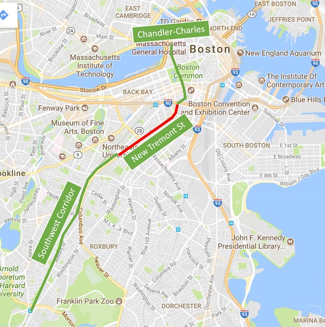
Figure 8: Continuous low-stress bike route in and out of downtown Boston, including the newly designed portion of Tremont Street
III. Design Goals
- Collector Road Get rid of all of the through traffic on Tremont to make it a neighborhood collector road. We will also add in bike facilities since bikers also need a safe collector road so that they can leave their homes and bike around the city.
- Bicycle Friendliness A redesign of Tremont Street could potentially serve as a major component in Boston’s bicycle network, connecting the popular Southwest Corridor bike path with the Chandler-Charles bike route to Downtown Boston.
- Crossability Make Tremont easy to cross, enabling the South End to feel like one continuous neighborhood rather than two areas separated by a large street. We will minimize crossing distances, ensure pedestrians will never have to cross more than one direction of traffic without a crossing island, and reduce the speeds of cars so that they can stop more quickly when they see a pedestrian about to cross.
- Parking Maintain as much parking as possible for residents and business customers.
- Bus Transit Provide facilities for bus stops and allow buses to easily exit and reenter traffic.
- Separation Separate modes of traffic where they may conflict with one another. This includes not only separating pedestrian, bike, and car traffic, but also separating bus transit from car traffic when they are at bus stops, and loading zones from normal parking spots during certain hours.
IV. Design Details
Street Design:
Horizontal Dimensions
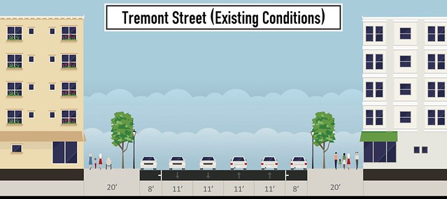
Figure 9a: Existing conditions of Tremont Street illustrated using StreetMix
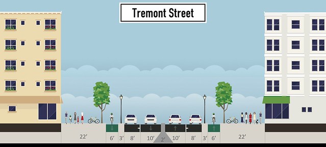
Figure 9b: Proposed new design of Tremont Street illustrated using StreetMix
Shown above in Figures 9a and 9b is a StreetMix design of the existing conditions of Tremont, and the proposed design for the street. All told, the Tremont Street roadway will be narrowed a total of 11 feet in each direction. This space is then more efficiently used for pedestrians and cyclists, as it will establish Tremont as a neighborhood street rather than a thoroughfare.
Our sidewalk is set up so that there is 22 feet of pedestrian space on each side. Each sidewalk will have trees and bicycle parking, promoting a walkable street and providing bicycle access to businesses. Beyond the sidewalk is a cycle track and a three-foot buffer between the bike lane and parking lane to house street furniture and prevent dooring. All this results in a wide sidewalk which allows businesses to operate in a part of the sidewalk (cafes with outdoor seating, shops with outdoor racks, etc.). The wide, one-way cycle tracks appear on both sides of the street and allow for side-by-side riding.
As of January 4, 2017, the speed limit of Tremont is 25 miles per hour (reduced from 30mph). Even though the speed limit changed, nothing about the design of the road did. Therefore, the changed has made practically no difference on Tremont. People rarely go this speed since the design of the road still invites high speeds. There are two lanes on each side of the street which allows for passing, and subsequently allows speeding if the passer wants to go faster than a driver going the speed limit. Tremont is also a wide, straight swath of asphalt, which makes drivers more comfortable at higher speeds.
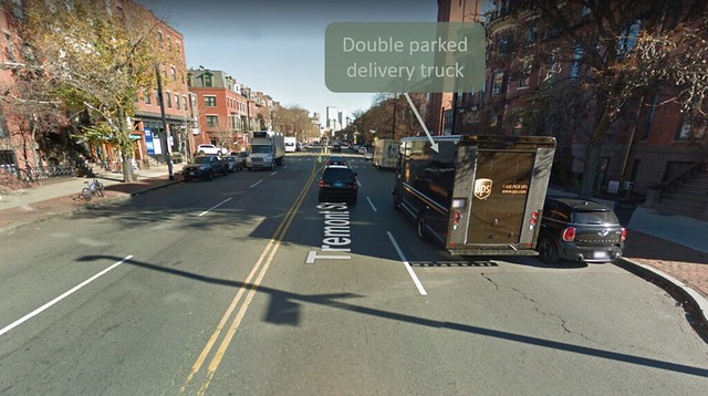
Figure 10: Illustration of frequent double-parking on Tremont Street, making it effectively a 1+1 road
To ensure the 25 miles per hour speed limit is self-enforcing, Tremont Street will be changed from two lanes in each direction to one lane in each direction. This road diet can be justified for three main reasons. The first is that, on Tremont, it is quite common to see cars double parked, blocking one lane and essentially making Tremont a one-lane road anyway (see Figure 10). The second reason is that even when cars are not double parked, 2+2 lane roads are often blocked in their left-hand lanes by cars waiting to cross oncoming traffic to turn left. Therefore, the road can usually carry just as much volume in one lane if space is provided through traffic to get around left-turning cars.
The travel lanes will also be narrowed from eleven feet to ten. Two ten-foot travel lanes give cars ample room to drive, without giving them enough room to comfortably speed. As for wider vehicles, there is a two-foot mountable cobblestone median on which they can drive (despite some minor discomfort).This design decision was inspired by Ruys de Beerenbrouckstraat in the Netherlands, if you’d like to learn more about the road, click here.
Vertical Dimensions
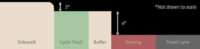
Figure 11: Proposed curb design on Tremont Street
To keep each mode of traffic separate, we are also installing curbs within our design, the dimensions of which can be seen in Figure 11 above. Vertical separation is very important in keeping different types of traffic separate from one another, as it is uncomfortable for anyone to run a curb or walk on two different levels. The transition from the sidewalk to the cycle track is made with a soft curb versus a hard one so that bikers can leave the bike lane and enter the sidewalk to park their bikes. Conversely, a hard curb between the parked cars and buffer deters cars from leaving the roadway for any reason.
Materials
The materials of each section of a road are supposed to effectively communicate each road user’s place without the use of street signs or other aids. A well designed road should accomplish this while also being visually appealing (in this case that means seamlessly fitting into Boston’s historic South End). Below, in Figure 12 you can see the proposed base material layout on Tremont Street.
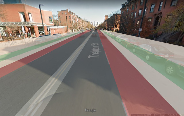
Figure 12: Overlay of proposed material usage on Tremont Street
Cars will drive on the trademark black asphalt, parked cars will be on brick, and the median will be cobblestone. We want the median and parking lanes to be a different material to make the asphalt travel lanes appear thinner, forcing drivers to be more careful of where they are in the road. The cobblestone median is also important because cobblestone is uncomfortable for normal cars to drive on, but for larger, wider vehicles that will need to mount it, it isn’t as uncomfortable.
The sidewalks could either be cement or brick, but for diagram purposes we are coloring them tan so they aren’t confused with any other road section. Currently Tremont has cement sidewalks but many Boston streets do have brick sidewalks and this could be an alternative for designers.
In the Netherlands, there are countless examples of how the Dutch use their materials to communicate the function of a road. Figure 13 below is an example of a typical Dutch street and the materials that they use.
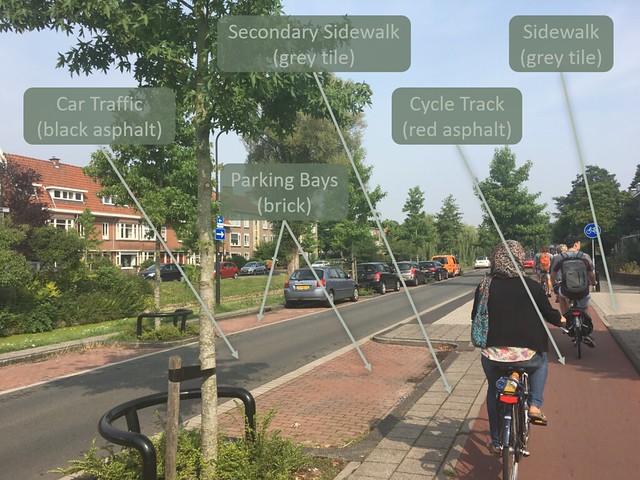
Figure 13: Dutch example of consistent paving material usage
Note how they only use black asphalt where they need to, not just as a default. In America our primary device to communicate what part of the road is assigned to what type of user are signs and paint, all of it on black asphalt. However, signs and striping often go unheeded. Instead, drivers see wide areas of black asphalt and feel comfortable speeding. Ideally, every road user feels comfortable in their own space, not just cars; and designs like the one above achieve that. If you would like to read more about the Dutch use of different materials to communicate road uses, click here.
Unsignalized Intersections:
Along Tremont Street between Melnea Cass Boulevard and Herald Street there are several small intersections that connect Tremont to South End residential streets. Many of these residential streets are one-way, and often change their direction when they intersect Tremont (either converging towards or diverging away from Tremont). After some careful consideration, it was decided that these intersections will be split into two categories: wide unsignalized and narrow unsignalized. Every intersection of each classification will have the same design under the proposed plan. If you want to learn more about Ruys de Beerenbrouckstraat, click here.
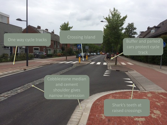
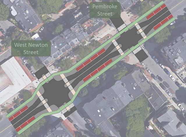
Figure 15: Proposed design of wide (left) and narrow (right) un-signalized intersections on Tremont Street
Figure 15 above is a bird’s-eye view of Tremont Street in the South End overlaid with the proposed design of wide and narrow unsignalized intersections. The intersection of Tremont Street with West Newton Street is an example of an unsignalized wide intersection. This type of intersection is designed for cross streets such as Hammond, Northampton, and West Newton Streets, and Union Park. While these streets are still local neighborhood roads, they are somewhat wider and have two way traffic. There are a few main design features of this intersection to highlight. The first is widening the central median from two feet to eight feet, allowing for the creation of a non-mountable crossing island and narrowing the travel lanes to nine and a half feet, which will contribute to traffic calming at the intersection. The cycle track bends away from Tremont Street to cross the side street while staying parallel with Tremont. Cars will meet bicycle and pedestrian traffic and at a 90 degree angle and on a raised crossing. This will ensure maximum visibility for both drivers and cyclists while also forcing the cars to maintain a low, safe speed.
The intersection of Tremont Street and Pembroke Street is an example of a narrow unsignaled intersection. These intersections will be implemented at the numerous intersections with small, local, residential streets in Boston’s South End such as Concord, Worcester, and Springfield Streets. Compared to the unsignalized wide intersections, these narrow intersections are smaller and the cross streets are usually unlaned, with lower average daily traffic (ADT). As a result, the travel speeds are much lower than on the wider neighborhood roads. Like the wide unsignalized intersections, these narrow ones feature the same widening of the median, narrowing of the travel lane, and raised crossings. However, the cycle tracks do not have any turns, nor are there crossing islands on the cross streets. These treatments were deemed unnecessary for the minor intersections due to the low volume of cars on the cross streets, and the low speed at which cars travel on local streets in the South End. Additionally, costs can be reduced if said treatments are omitted on narrow intersections.
Included at all these unsignalized intersections will be S-curves at the crossing islands. As stated above, the cobblestone median will widen from two feet to a eight-foot crossing island. Furthermore, the parking lane will end, allowing the curb to shift to the right (from the driver’s perspective). With both edges of the lane shifting, a chicane or S-curve will be created, hindering the drivers’ abilities to reach high speeds. This limits the potential for a serious, high speed crash with another car. It also protects pedestrians, as cars will be travelling through the intersection at the slowest possible speed, which is achieved directly after the S-curve. As seen on Ruys de Beerenbrouckstraat, it is commonplace in the Netherlands to create S-curves by flaring out crossing islands and eliminating parking at crossings which, in turn, yield average speeds around 40 km/h.
These unsignalized intersections provide order for traffic flow, but also have enough safety measures to give pedestrians and cyclists priority. Including Melnea Cass Blvd. and Herald St., there are 34 intersections on the section of Tremont Street that is focused on. With intersections occurring as close as 200 feet, it would be impractical and unnecessary to implement signaled intersections at every crossing. Many of these streets in the South End are local neighborhoods with low daily traffic. Few people other than residents will use these streets, and is therefore acceptable to have unsignalized intersections for local neighborhoods.
Melnea Cass Boulevard Intersection:
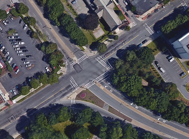
Figure 16a: Existing conditions of the intersection between Melnea Cass Boulevard and Tremont Street
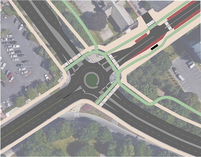
Figure 16b: Proposed redesign of the intersection between Melnea Cass Boulevard and Tremont Street
The Melnea Cass Boulevard Intersection with Tremont Street experiences high traffic volumes at peak times, as Melnea Cass is a connector road to Interstate 93. The intersection is currently signalized for vehicles and pedestrian crossings. Despite signalization, the intersection remains daunting and less safe than it could and should be. This is because crossing Tremont Street here means crossing 60 feet of asphalt in a limited signal cycle. Such a hectic intersection causes a disconnect between pedestrians’ perceived safety while crossing the intersection versus the actual safety while crossing the intersection. Signalized intersections are safe for pedestrians, but some cars make right turns on reds and enter crosswalks that are supposed to be signalized and protected.
Rights on reds are not only scary for pedestrians, they are also unsafe in an intersection designed like this. For maximum visibility, vehicles should intersect with cyclist and pedestrian crossings at right angles, since the driver can most easily see pedestrians and cyclists from both directions at that angle. Since Melnea Cass and Tremont intersect on a diagonal and there are no corner islands that make the intersection more perpendicular, this intersection between cars and lighter road users is dangerous.
To fix this problem, we propose a roundabout (seen in Figure 16b), which, in tandem with crossing islands, allows pedestrians and bikers to cross one travel lane at a time. Each travel lane approaches and leaves the roundabout with medians or curb edges on either side, and it is these curbs that are used to make the crossing islands. Allowing road users to cross an intersection one lane at a time enormously improves the overall safety of the intersection.
This new roundabout will be a form of roundabout known as a “knee roundabout.” The knee roundabout gets its name because it is designed for the majority of traffic to flow through the roundabout at a 90 degree angle, resembling a bent knee. The knee roundabout serves as a two lane roundabout, which will keep the bypass lane (although with a new, tighter radius) that takes cars from Tremont Street to Melnea Cass Boulevard. This bypass lane is critical to the redesign, as through traffic travels from Tremont to Interstate 93 via Melnea Cass. This diversion of through traffic provides the opportunity to make Tremont Street north of Melnea Cass Boulevard 1+1, as the incompatible road function of through traffic is removed. It also provides a smooth transition from 2+2 Tremont Street to 1+1 Tremont Street. If you would like to learn more about roundabouts and how they make intersections safer, click here.
In the existing intersection design, the bus stop (shown in Figure 16b in black, with red pavement in front) is shared with the parking lane, and is very close to the edge of the intersection. Buses are large vehicles and block sight lines from drivers to pedestrians and cyclists, and vice versa. That’s why for the redesign, the bus stop is shifted farther away from the intersection, and given a loading bay within the parking lane. This makes crosswalks visible to drivers and keeps the one travel lane unblocked by a stopped bus. Additionally, enough space is provided so that buses can easily pull up to the curb at the stop, improving service.
Massachusetts Avenue Intersection:
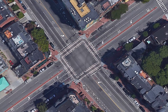
Figure 17a: Existing conditions of the intersection between Massachusetts Avenue and Tremont Street
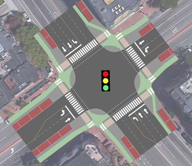
Figure 17b: Proposed redesign of the intersection between Massachusetts Avenue and Tremont Street
For the intersection of Massachusetts Avenue (Mass Ave) and Tremont Street (existing conditions in Figure 17a), a signalized protected intersection was deemed to be the best type of intersection (shown in Figure 17b). This is because Mass Ave is a large road with five lanes at the intersection. It is unsafe for bikes to mix with cars in such a large intersection due to numerous conflict points. A signalized protected intersection keeps bikes separate from the cars and the pedestrians, ensuring safety for all road users. An additional safety feature built into signalized protected intersections are the advanced stop lines for bikes. Bikes travelling in the same direction as cars stop at a line 20-30 feet ahead of cars. This increases visibility of vulnerable road users (bikes and pedestrians to cars).
This intersection also has an excess of pavement. This excess pavement means larger crossing distances and lane widths, making vehicular collisions more probable. With the new intersection, that space will be minimized by tightening lane widths, eliminating unnecessary travel lanes and making space for cycle tracks. Additionally, the intersection will be raised to sidewalk level to give handicapped persons an easier crossing, while also slowing cars down as they cross through the intersection.
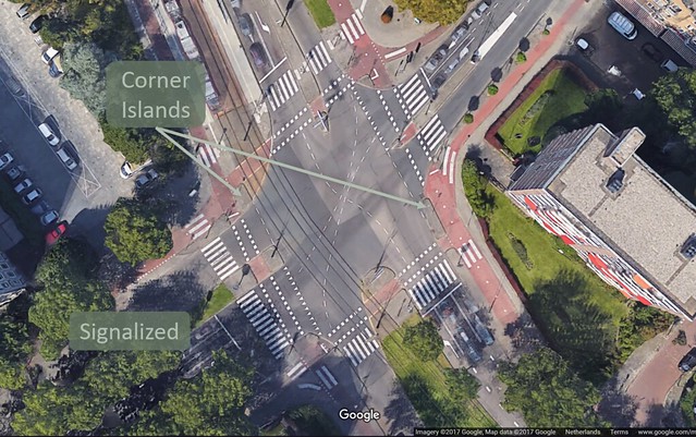
Figure 18: Dutch example of protected intersection that inspired the redesign of the Massachusetts Avenue-Tremont Street intersection
What makes a protected intersection so safe are the corner islands. You can see these in the picture above in Figure 18. This example is in Rijswijk at Burgemeester Eslenlaan, Generaal Spoorlaan, and Hendrik Ravesteijnplein. These corner islands separate bikers from cars and force them to intersect at sharp angles so that the cars have the maximum visibility they could have. As for signalization, people riding bikes and pedestrians will cross at the same time, and cars will drive through separately. Crossings for pedestrians are marked with zebra stripes, and crossings for bikes are marked with elephant feet.
Dartmouth Street Intersection:
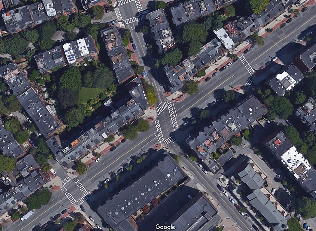
Figure 19a: Existing conditions of the intersection between Dartmouth and Tremont Streets
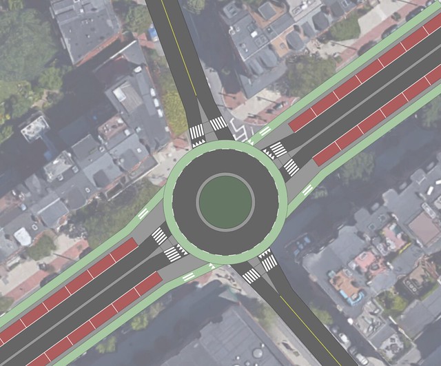
Figure 19b: Proposed redesign of the intersection between Dartmouth and Tremont Streets
Today, Dartmouth Street exists as a signalized intersection (a bird’s-eye view is shown in Figure 19a). However, the traffic volumes on each street are such that a roundabout could be installed at the intersection without exceeding its capacity. Based on this assumption, a roundabout was proposed at the intersection of Tremont and Dartmouth (shown in Figure 19b). Installation of a roundabout would also increase the safety of the intersection for bikes and pedestrians, and therefore all road users.
Signalized intersections fail to address the issue of vehicular right turns on red. These types of turns are supposed to be illegal in Boston, but the rule is rarely enforced. The roundabout will keep pedestrians and cyclists safe at all times as pedestrians and cyclists will be given priority at all crossings. This is done using zebra stripes and sharks teeth. Additionally, there is a median between travel lanes on the edge of the roundabout, which serve as pedestrian crossing islands. This means that pedestrians only have to cross one lane of vehicle traffic at a time, which is manageable for even the most vulnerable: young children and the elderly. This results in less stress for all users, as vehicles know to watch and yield to cyclists and pedestrians.
Due to the size of the intersection, there was not enough space to incorporate separated cycle tracks into the design. Instead, bike lanes will be added to the outer edge of the roundabout. Many road designers in the United States are hesitant to put bike lanes on roundabouts, claiming they are dangerous for bikes. However, giving bicycles a space of their own on the roundabout is favorable to integrating drivers and cyclists, who will likely either stay to the right anyway (as they do in normal shared spaces) or slow down car traffic by claiming the entire lane (this will be difficult in a wide 17-foot lane). Furthermore, by giving bicycles a visible space within the roundabout, car drivers will be more likely to expect and and be wary of cyclists. The only serious concern for cyclists traveling in bike lanes in a roundabout comes from large semi trucks, which are very unwieldy and can hit bikes without even seeing them. However, this will likely not be a problem on the new Tremont Street as it will not be an attractive route for such trucks to take.
Berkeley Street Intersection:
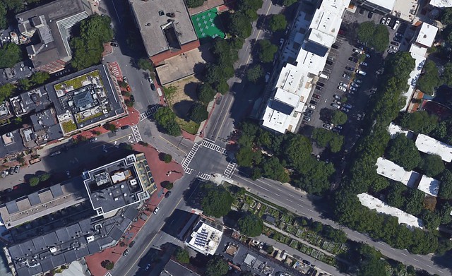
Figure 20a: Existing conditions of the intersection between Berkeley and Tremont Streets
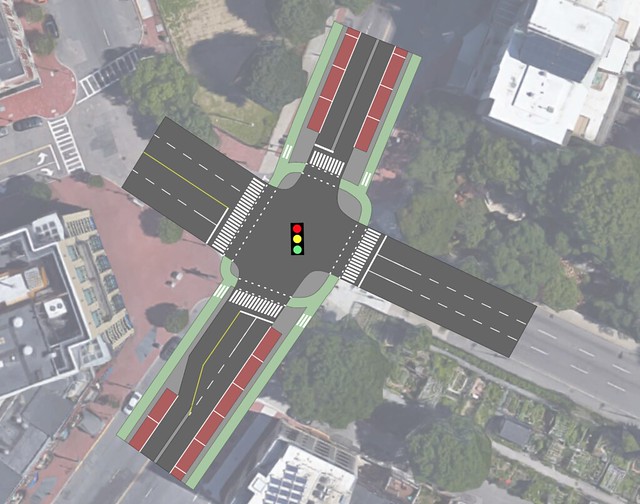
Figure 20b: Proposed redesign of the intersection between Berkeley and Tremont Streets
The intersection of Berkeley and Tremont Streets (existing conditions shown in Figure 20a) is one of the most unique ones in the South End. Three lanes of one way traffic and a 2+2 lane road intersection with Tremont from the southeast and northwest respectively. It currently exists as a signalized intersection, and that is what it will stay under the proposed plan. Any other form of intersection was deemed too dangerous or complicated due to the unusual directionality of Berkeley at the intersection. However, there will be significant changes made to Tremont (Berkeley will remain unchanged).
Firstly, the signalized intersection will be made protected for bicyclists and pedestrians, keeping Tremont bicycle and pedestrian friendly (shown in Figure 20b). In addition, Tremont will be widened in the northeast bound direction on the southwest leg of the intersection. The two-foot median will end and parking on one side of the street will also end, eliminating three parking spots. The two feet saved from the median and the eight feet saved from the parking lane makes room for a ten-foot left turn pocket. This pocket was deemed necessary due to the high volume of northbound traffic on Berkeley Street, as it can serve as a connector road to Interstate 90 and Storrow Drive.
Other Considerations:
Commercial Sector
Figure 21: Map of all the businesses (blue dots) and proposed loading zones (red dots) on Tremont Street in Boston’s South End
Tremont Street is composed of residential and business areas. Figure 21 above shows all businesses — of which there are 89 total establishments — and the proposed loading zones on Tremont Street. The blue dots represent the businesses and the orange dots represent the proposed loading zone parkings. Most, if not all, of these businesses use a delivery truck to get their merchandise on a daily basis. Therefore we must include an area reserved for these deliveries in order to avoid double parking. Shown below in Figure 22 is an example of double parking in Tremont. On the right there is a truck unloading merchandise on one of the travel lanes. Also on the left there is a UPS truck also double parking to deliver the mail.
Figure 22: Example of how loading and unloading looks on Tremont today
We counted the number of business per block and plan to manage three parking spaces on blocks with two or more businesses in order to accommodate a loading zone for a specific time period. Trucks will be able to load and unload from 8:00am to 12:00pm. After that, the loading zone will be a normal on-street parking spot that will be marked with an X and a street sign indicating the time period for loading and unloading. An example in the Netherlands (Rijswijkseweg in The Hague) is shown below (Figure 23). It is similar to Tremont in the sense that they have businesses and residents on the same block. To accommodate both, the Dutch left most on street parking but replaced some parking with a loading zone. In total there will be 20 loading zone parkings on Tremont. The whole parking lane will also be brick instead of asphalt to better distinguish between types of lanes. If there are no cars parked, cars on the travel lane will keep to their lane and not invade the parking lane to have a wider space.
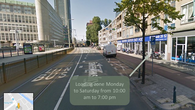
Figure 23: Dutch example of temporary loading zones that served as inspiration for the proposed design on Tremont Street
Boston Fire Department
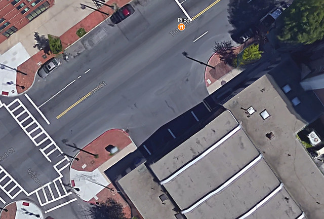
Figure 24a: Existing conditions of the fire station on Tremont Street
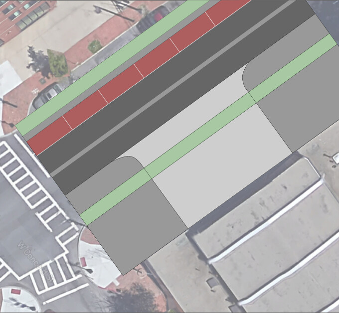
Figure 24b: Proposed redesign of the entrance to the fire station on Tremont Street
An unusual aspect of Tremont Street is that it has a fire station on it. To deal with this, we will take out the grass divider between the bike track and road, the median, and car parking lane for the 50-foot width the entrance/exit takes up and install a 7.5’ curved apron (4.44% grade) to ensure fire trucks can easily exit the station. Existing conditions and the proposed updated design are shown above in Figures 24a and 24b respectively.
V. Conclusion
There is a lot of potential for roads in the United States to emulate those found in cycle-friendly countries like the Netherlands and Denmark. The roadways are certainly wide enough and, as one of the most powerful nations in the world, the U.S. certainly has the engineers to design better infrastructure, the capital to fund it, and the labor to build it. Yet there are still so few cities that have embraced ‘All But Car’ (ABC) travel. Coming to the Netherlands to study has shown us that it is not terribly difficult to drastically improve certain streets in American cities.
Studying transportation in the Netherlands has also given Fresh Thinking a greater appreciation for all the factors that must be considered when designing a road network. A change on one street can have repercussions on neighboring streets and/or neighborhoods. Consequently, while designing a single street may not be in itself extremely difficult, overhauling an entire urban road network—which has been shown to be necessary if ABC travel is to be truly ubiquitous—is more difficult. Moreover, the transition to ABC will likely be even harder in the United States due to its history of endorsing vehicular cycling theory and similar schools of thought. However, there are steps being taken to turn this around and if the culture in the United States were to change, it has the potential to pay dividends for our public health, happiness, and carbon footprint.
Our design goals help to change and clarify Tremont Street’s functionality. Demoting Tremont Street with narrower lanes, raised crossings, and cycle tracks will change its classification from a through road to a neighborhood collector road. Providing loading zones and ensuring that there are enough parking spaces will fulfill Tremont Street’s functionality as a street serving local businesses. Adding pedestrian crossing islands, signaled intersections, and sharks teeth to determine who needs to yield the right of way will increase Tremont’s crossability, which will remove Tremont’s functionality of being a barrier and will unite both sides of the South End. Tremont Street’s functions of serving local businesses, being easily crossable, providing abundant parking, and a serving as a residential collector road are all compatible, and the proposed design of Tremont preserves all these functions. At the same time, the incompatible function of maintaining Tremont as a through road has been eliminated through the proposed design. This will reverse the detriment to road safety and the South End’s identity. Removing the function of a through street will help make Tremont more of a focal point of the neighborhood and help unite the South End as a whole.
Success is made up of a series of small steps, and this redesign of Tremont is no doubt one small step in changing the culture of transportation in Boston. If this design of Tremont Street were to be implemented, it is highly likely that traffic would slow in speed and lessen in volume, pedestrians would be safer, and bicycle traffic would increase. It would also serve as an example to the rest of Boston of what can be achieved on the existing city streets.
References
Boston Bike Network Plan [PDF]. (2013). Boston: Boston Department of Transportation.
Building the Protected Intersection [PDF]. (2015, December). Portland: Alta Planning Design.
“Definition of Functional Classification.” MassDOT. Massachusetts Department of Transportation, 2017. Web. 10 July 2017.
Furth, P. (2017, July 5). Systematic Safety. Lecture presented in Netherlands, Delft.
Gans, F. (2017, January 8). Boston’s 25 mile-per-hour default speed limit takes effect Monday. Boston Globe.
Planas, A. (2017, May 30). Pedestrian killed in South End accident. Boston Herald.
South End residents raise concerns after pedestrians hit. (2015, November 5). Fox 25 Boston.