
Ruys de Beerenbrouckstraat
1960s Function
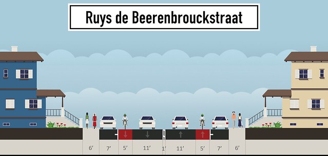
Beginning in the 1960s, Ruys de Beerenbrouckstraat served a very similar purpose to Tremont Street; a through road that carried traffic into the city center. Cars had higher priority than they do now, as there were only bike lanes rather than cycle tracks with wide travel lanes in each direction. Like Tremont Street, the relatively straight nature, wide lanes, and few crossing islands encouraged high speed travel and passing during low traffic times such as later at night. Delft developed a ring road around the historic city center and restricted vehicle access within that ring road. Ruys de Beerenbrouckstraat was demoted to a lower speed local road, and traffic was diverted. Since this road is in the northwestern corner of Delft’s ring road, traffic from points north such as Rijswijk and The Hague can be diverted to Vrijenbanselaan while traffic from points west such as Den Hoorn can be diverted south to Westlandseweg. The implementation of ring roads and other high traffic routes into the center of Delft diminishes the need for Ruys de Beerenbrouckstraat to function as a through street. Similarly in Boston, ring roads such as Melnea Cass Blvd. link to I-93 to bring traffic into downtown, which reduces the need of Tremont Street to function as a through road to downtown Boston.
Current Function
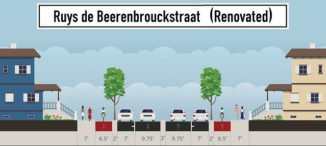
Ruys de Beerenbrouckstraat and Tremont Street also have multiple functions today, with a combination of commercial and residential sections. Ruys de Beerenbrouckstraat is a neighborhood for the first four intersections (going westward) between Hof van Delftlaan and Kappeyne van de Coppellostraat, but becomes more commercialized due to an Albert Heijn grocery store and other businesses. The commercial section of Ruys de Beerenbrouckstraat sees more traffic due to the Albert Heijn and must also accommodate trucks to deliver goods. As a result, the neighborhood section must discourage through traffic, but must be wide enough to accommodate large trucks to make their deliveries, resulting in a cobblestone median which allows trucks to fit while enforcing a 40 km/h speed limit with cars. Meanwhile, Tremont Street has a residential area between approximately Mass Ave. and Pembroke Street. It is more heavily commercialized south of Mass Ave.and between Pembroke and Harold Streets. Like Ruys de Beerenbrouckstraat, the commercial blocks must allow trucks to make deliveries (and by extension allow trucks to fit through the residential sections) while also discouraging through traffic and keeping traffic that does pass through at a low speed.
Steps Taken to Change Function
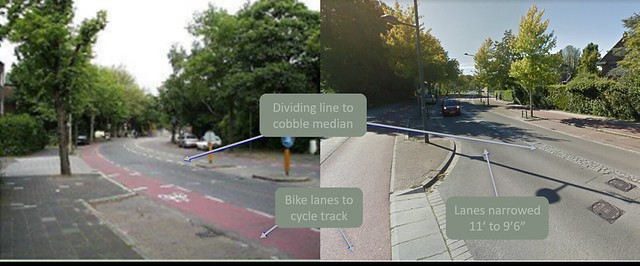
To reflect the reduced demand due to ring roads, Ruys de Beerenbrouckstraat underwent a road diet and was demoted from 2 lanes in each direction to a 1+1 configuration with a cobblestone median. This median can be driven on by larger vehicles due to narrow 10 foot lanes, but is uncomfortable for smaller cars due to the bumpy cobblestone surface. Crossing islands are used to prevent pedestrians from crossing more than one lane of traffic at a time. Bikes are also separated from the road in separate cycle tracks. To protect other cars, bikes, and pedestrians at intersections, the surface is raised as a crossing table with a different textured surface to alert drivers they are entering an intersection. Outside of intersections, S-curves, speed humps, and textured surfaces are all used as measures to keep drivers slow through neighborhoods and commercial districts with high pedestrian traffic. Ruys de Beerenbrouckstraat has the same purpose as Tremont Street and at one time, had the same design. Therefore, Tremont Street can be demoted in the same way and receive the same elements as Ruys de Beerenbrouckstraat.
References
Original Ruys de Beerenbrouckstraat Photo: Courtesy of Jan Nederveen in Delft city planning Presentation, 2017.