
Background:
The bike highway from Delft to Rotterdam began at TU Delft at Jaffalaan and continued to Rotterdamseweg. The longest portion of the bike highway trip continued along Rotterdamseweg and Delftweg, which are adjacent to a canal, Delfts Schie. This portion travelled through small towns, green space, farmland, and ended up in the town of Overschie. In Overschie, the bike highway began to run adjacent to the motor vehicle flow road, A13, until it travelled under the A13 and A20 intersection and continued along the Delfshavense Schie canal. The cycle track along the Delfshavense Schie continued all the way to the maastunnel at the Nieuwe Maas distributary river.
Description:
The Delft – Rotterdam bike highway route began in Delft and continued to Maas Tunnel in Rotterdam in the distributary of the Rhine River, Nieuwe Maas. The route is about 14.9 kilometers (9.2 miles) long and is distinguishable by five segments (see the map below). Segment A was the first and longest stretch of the bike highway from Delft to Overschie. It travelled along Rotterdamseweg and Delftweg and consisted primarily of cycle tracks either adjacent to the roadway in a city/town setting or next to an open field (my personal favorite). Segment B began and ended in Overschie. The bike highway was primarily mixed-use throughout this segment, but featured some advisory lanes in town centers. Segment C continued from Overschie, along the A13 highway, and finished at the intersection of A13 and A20. This segment of the highway primarily featured a separated cycle track adjacent to the street and following the flow road. Segment D began at the highway intersection underpass (A13 and A20) and continued through Rotterdam along the Delfshavense Schie canal to the Maastunnel. This segment featured separated cycle tracks along the length of the canal. Finally, segment E was the portion of the bike highway that continues through the maastunnel under the canal.
Route Statistics:
- The bike highway route was 9.2 miles long
- It featured 4 stoplights, 0 roundabouts, and 8 street overpasses
- There was one yield point at a traffic crossing
- 100% of the route featured overhead lighting
- The bike highway was 70% cycle track, 15% stand-alone path and 15% on-street/mixed-use cycling
Wayfinding:
I found that the bike highway appeared to be completely connected. The only portion of the bike highway path that I found a little difficult to follow was in Overschie. The bike highway went from a clearly defined cycle track adjacent to the roadway to a mixed-use street where cars and bikes shared the road. There was nothing wrong with this change of surfacing and bicycle infrastructure because it was still very comfortable to bike in that town; however, there was a turn onto De Lugt that Jude and I missed. Luckily, Justin and Rick had biked the route the previous weekend and warned us of this tricky turn and we realized the mistake we made very quickly.
We attempted to follow the way-finding signs throughout our route; however, as we had been warned about the tricky turn, we utilized the google map application on our phones more than we should have. We did not get to fully appreciate the usefulness of the way-finding signs. We also ran into Nick and Erin on our route to Rotterdam and they warned us of another tricky movement just before the entrance to the maastunnel. Therefore, we were prepared for and searching for the intersection they had mentioned as opposed to utilizing the directional signs.
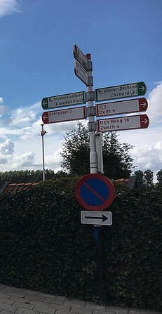
Although Jude and I did not experience the full effects of the directional signage on the bike highway route, I did utilize them on a separate trip to the Maeslantkering storm surge barrier. We got lost on the way to Maeslantkering, and what should have taken us a little over an hour to ride to ended up taking two hours. On the way back we went through Massland and utilized the way-finding signs and the electrical engineering building at TU Delft to navigate our way back. The signs were frequent and consistent. They appeared on the side of the road right when you started to ask yourself what the next direction in the route would be. They were extremely helpful.
Fun Feature:
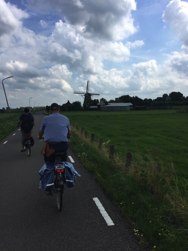
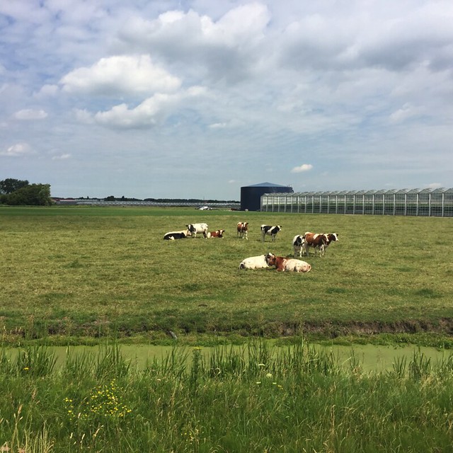
I’m from a small farm town in New Hampshire so I’ve always been a fan of rolling hills and farmland as opposed to bustling towns and city centers. We’ve gone on a couple nature trail bike rides, and my favorite ride was definitely the small dirt road through the flowers on the way back from Pijnacker-Nootdorp that featured numerous old-style windmills (see first picture). I was excited to find that a large segment of the bike highway ride to Rotterdam included the scenery I enjoy. The segment along Rotterdamseweg and Delftsweg ran adjacent to fields full of cows, goats, and sheep. There was a lot of green space to gaze upon, trees lined both sides of the cycle track, and with the light breeze blowing against your face it constituted a really enjoyable ride (see second picture).
Conclusion:
This bike highway could be characterized as fast, simple and efficient. I don’t know that I would choose this route as a commute as it requires much more time than I would be willing to expend in the morning on the way to work; however, if you were looking to explore Rotterdam on a weekend or day off and were not in a rush, this path can easily get you there. It’s a long but enjoyable ride, and there aren’t many major turns to be made along the route resulting in an easily navigable route.