
2.3 PREVENT CUT THROUGH TRAFFIC IN NEIGHBORHOODS
Justin Clark
Background
Traffic is always a problem for drivers, especially during rush hour. When the fastest route is backed up, people tend to look for some kind of cut through to dodge some of the traffic and get closer to the destination. Finding that perfect cut through street as a driver can make a commute so much better, but if this cut through is in a residential area or neighborhood, it can be dangerous to those living there. This type of driving is called rat running. When a street becomes known as a cut through, residents in the area begin to complain due to the excess volume and new danger when using the once quiet road. In order to prevent rat running, the installation of a traffic-calming device such as a speed hump can be used, as well as making parts of the road one way to control the direction of traffic on the road. These measures have been taken on three particular areas: The Da Costalaan Neighborhood in Rijswijk, Buitenwatersloot in Delft and Rijswijkse Landingslaan in Ypenburgh.
The Da Costalaan Neighborhood is right off of Haagweg and Geestbrugweg, and would provide a nice cut through for someone traveling along Geestbrugweg attempting to travel north along Haagweg, but is stuck behind a bus. Geestbrugweg has many bus stops along its street, and during rush hour this could add to the traffic, so the Da Costalaan Neighborhood could provide a nice cut through. The Da Costalaan also contains a school in it, so an increase in car traffic would be dangerous for the children walking or biking to school.
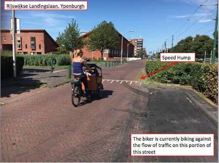
Rijswijkse Landingslaan is near a shopping mall in Ypenburgh, which would lead to congestion in the area. Coming from the shopping mall, one is supposed to use Plesmanlaan, but if the area was congested one could drive down to Rijswijkse Landingslaan to continue towards the main roads. To avoid mall traffic one could take Rijswijkse Landingslaan to get to Singel or Rijswijkse Waterweg, which are the two main roads in the area. A tram line runs parallel to this street, so people would most likely be walking to the station from this area, and having cars speed up and down Rijswijkse Landingslaan would be dangerous for someone coming off the tram and expecting to cross a quiet street with ease.
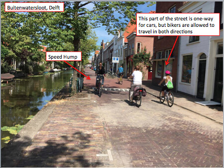
Buitenwatersloot is located parallel to Westlandseweg which is a main street, so when this street becomes heavily populated it appears that Buitenwatersloot is an ideal route. A bus route is located along the street and there is also a school on the corner of Krakeelpolderweg, a main road that is perpendicular to Buitenwatersloot.
Preventing Cut Throughs
One of the main concepts of preventing rat running is to slow down the cars to make the road safer and less desirable to be used. Speed humps help with slowing down the cars, but some cars will still speed over a speed hump, so other measures must be taken. A tactic used is changing some of the street to being one way in opposite directions, so the street itself is no longer a cut through, and drivers must turn off the street to continue going in the direction they wish to travel in. This makes the streets less desirable to use because not only do they have speed humps, they do not even continue towards the destination you thought you were cutting through to get to.
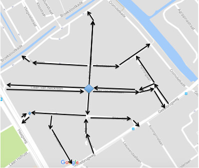
Above is an image of the Da Costalaan Neighborhood. The arrows are displaying the one ways used in this neighborhood to prevent rat running. The center diamond is where the two way street Caan van Necklaan gets blocked by a permeable barrier, forcing cars on this street to turn left or right, never continuing straight.
Da Costalaan has many speed humps throughout averaging to be about 30 meters apart, and appearing any time a street is connecting to another street. Below is a map displaying the speed humps in the neighborhood, each point represents a speed hump.
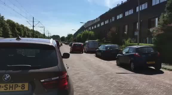
This video is from the Da Costalaan neighborhood. You can see the car slow down at the speed hump, as well as having to turn off the road it was traveling on as the road ahead turned into a one way and they could not enter.
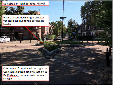
Above is another image from Da Costalaan. The permeable barrier prohibits cars traveling on the two-way street Caan van Necklaan from continuing straight, they must turn on to Da Costalaan. Meanwhile bikers are allowed to pass through and continue straight.
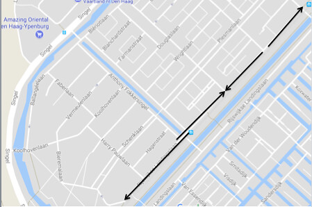
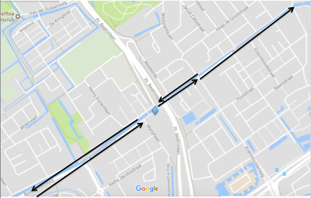
The image above displays the one ways on Rijswijkse Landingslaan. You can see there is a small overlap at one point, this is because there is one area on the street at the intersection of Anthony Fokkersingel that is two way to allow cars from Anthony Fokkersingel to choose which direction they would like to go. Below is a map of the speed humps located on Rijswijkse Landingslaan, the average distance between each hump was about 80 meters. Once again, each point represents a speed hump.
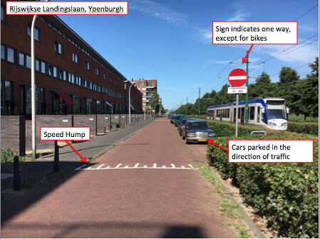
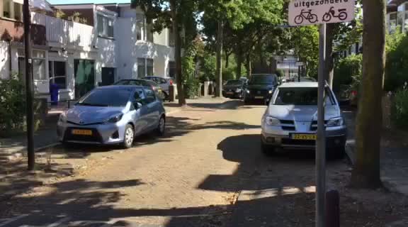
This image is from Rijswijkse Landingslaan and indicates the presence of a one way street and also shows what a typical speed hump looks like on the street.
The image above shows the direction of traffic on Buitenwatersloot. It is only one way for one portion. The diamond represents a barrier for cars, and the blank section where there are no areas is to signify that cars are not allowed in this area. Bikes and buses are allowed in the area. Below is a map that displays the speed humps along Buitenwatersloot. They are concentrated in the area that is one way. Each point represents a speed hump, about 40 meters apart, except for the point near Pr. Beatrixlaan. This point represents where there are used to be a raised bump in the ground to prevent cars from passing through but allowed buses and bikes to continue. That area is now monitored by a camera to enforce that cars are not allowed to go through with a fine.
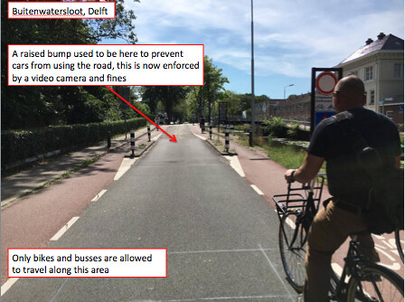
This image is from Buitenwatersloot where buses and bikes are allowed to travel on the street but cars aren’t. There used to be a raised bump that would lower for buses but stay up for cars, but that was changed and replaced with a video camera that is used to catch and fine car drivers if they use the road.
Another concept of preventing rat running is assuring that the streets not only feel safer for pedestrians and bikers, but that they are still accessible. When the street becomes a one way, it is only a one way for cars. Bikes are allowed to travel in both directions throughout the entire street, as are pedestrians. This encourages biking on these streets even though there are cars present, because cars are slowed down and cannot travel in both directions so this provides low stress biking. For all three investigated areas, bikes are allowed to travel in both directions throughout so even though these streets are not ideal to use by car, they are still usable by bike.
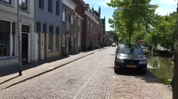
This is a video from Buitenwatersloot. The car can only travel in this one direction, and is hitting the speed bumps. Meanwhile the bikes can travel in both directions, with and against the flow of traffic. Cyclists traveling both ways on Buitenwatersloot is better illustrated in the image below.
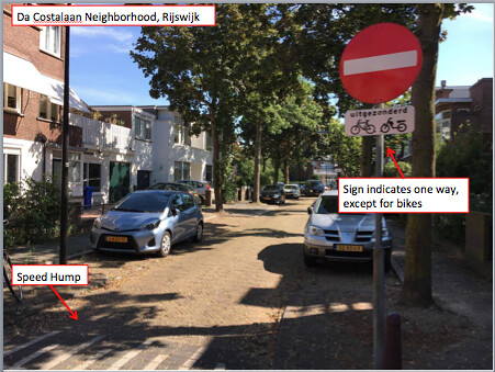
The image above can be found in Da Costalaan. The sign shows that cars can not enter, but that bikes are still allowed access.
Above is a short video on Rijswijkse Landingslaan of a biker traveling in the opposite direction of the flow of traffic. Below is an image of the same biker from the video from Rijswijkse Landingslaan. The biker is about to enter the one part of Rijswijkse Landingslaan that is two-way, near Anthony Fokkersingel. This allows for cars to choose whether they want to turn right or left, as the directions of the streets they would be turning on to are in opposite directions. There were not too many cars using this street, so finding a biker and a car together was tough. However, this means that the strategies used to prevent rat running were effective.
Applying to the U.S.
In the U.S., rat running is an issue in many areas. One particular street that could use a Dutch adaptation is Poplar Street from Washington Street to Metropolitan Avenue in Roslindale, MA. There have already been attempts to dropping the speed limit on this street from 30 to 20, but as we know the Dutch do not use signs. Poplar Street provides a cut through from Washington Street to Hyde Park Avenue instead of taking the Cummins Highway or Metropolitan Avenue. The commuter rail stop Roslindale Village is also close to Poplar Street, so it can be used to quickly access the stop if Washington Street is backed up. This is dangerous as Poplar Street is a residential area, and at one point it runs alongside a school, so that is a danger to the children to having cars use it as a cut through. There is also an area called the Poplar Street Play Area, so it can be expected to have many kids in this area, and a stray ball going across this street with someone speeding down it could become very bad. Poplar Street could have many speed humps installed along it to try to slow down traffic as well as making some parts of it one way. There are many parts of the street that have connecting streets, so when a driver gets to a one way, they would turn onto another street which would still take them towards their destination, but would add more time and make this street less desirable to use for rat running.
This map shows the area of Poplar Street that will be receiving some Dutch adaptations. You can see that there are 3 ways to head east from Washington Street: Cummins Highway, Poplar Street and Metropolitan Avenue. Cars should not be using Poplar Street because it is a residential area, so cars should be discouraged from taking this street.
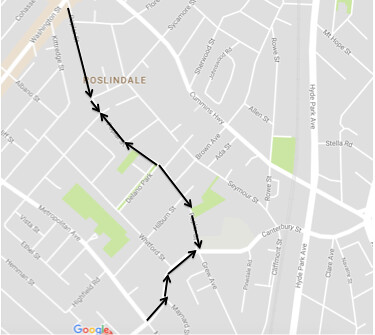
Below is an image with the proposed one ways along Poplar Street. The corner of Poplar and Canterbury has a school on it, so the one ways should lead to it for the sake of school buses.
Below is the map of Poplar Street with suggested speed humps. Anytime there is an intersection with another street there is a speed hump, otherwise I used Rijswijkse Landingslaan as an example for average distance between each speed hump, being 80 meters.