UNLIMITED PANCAKES ON DORCHESTER AVE
Team: Will, Tiffany, Anna
OVERVIEW
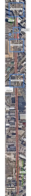
Dorchester Avenue is a historical road located in South Boston. The portion of Dorchester Avenue that we are focusing on is a 4800 ft (1.5 km) stretch that starts at Andrew Square and goes north to West Broadway. It is a long and straight road in the north-sound direction, contrasting to the diagonal grid of the adjacent streets aligned as seen in Figure 1. The road’s irregularity from its surroundings is because it used to be a turnpike in the 1830s that was used to transport freight. This was the most direct route that connected the south with the north. With the widening of Morrissey Blvd (1953) and the construction of Interstate-93 (1959), it is no longer the main highway to the south. However, it is still used frequently by commuters living in the south to travel to the metro Boston area because it is still one of the most direct routes connecting the two areas.
Most of the traffic currently on the avenue goes from south to north and exits to the west onto West 4th Street or West Broadway. There are alternatives to get into central Boston also seen in Figure 1, but these two streets presents the shortest path because it crosses over the railroad tracks and under the highway.

Figure 1 – Locus Map
Dorchester Avenue also possesses a lot of potential to help link the bicycle network in the area. As seen in Figure 2, there are two segments of bicycle facilities that can be connected if Dorchester Avenue upgrades their bicycle infrastructure – the trail at John Moneley Park and the trail passing Fort Point. We hope to change the blue disconnected portion of Dorchester Avenue to a green portion that connects to other dark green portions. Figure 2 also shows the types of facilities on different parts of the avenue. The existing facilities along Dorchester Avenue are the worst facilities, however, they can be improved for a better cycling experience.
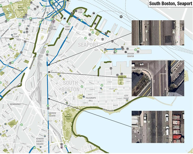
Figure 2 – Bike Connectivity
EXISTING CONDITIONS
Currently, Dorchester Avenue is located in a very industrial and manufacturing area as seen in Figure 3. Along the street on the right are mostly manufacturing while on the left, there are industries, railroad tracks, and a major highway. Behind the manufacturing area are residential housing units.
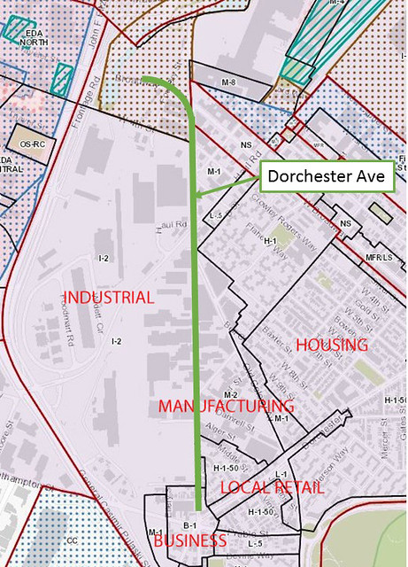
Figure 3: Land Use
Due to the heavily industrialized area, the street currently looks rather bleak. In Figure 4, we can see how the street is filled with industrial vehicles and littered with parking lots. There is not a nice, calm, peaceful living space here.
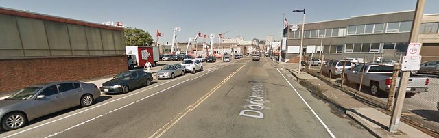
Figure 4: Industrial Dominance
Existing Traffic
Dorchester Avenue carries many commuters who live nearby in South Boston to work in metro Boston. Its main function is to transport a significant amount of traffic as seen in Figures 5 and 6. Figure 5 shows daily traffic counts which is 17,650 cars at West 4th Street, 17,000 cars at West Broadway, and 13,145 cars at Andrew’s Square. Figure 6 shows a typical PM peak traffic congestion for Dorchester Avenue. Most of the congestion occurs westbound on West 4th Street and West Broadway, which signifies the importance of those intersections. Furthermore, up north past West Broadway, Dorchester Avenue is closed to the public and is reserved for the United States Postal Service, so there isn’t much traffic going to that section of Dorchester Avenue.
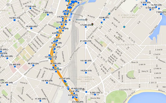
Figure 5 – Traffic Counts
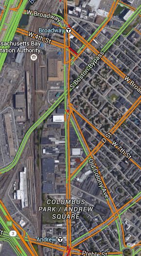
Figure 6 – Traffic Congestion
Bicycles
There are some parts of the road that are marked with sharrows as previously seen in Figure 2. For cyclists to have to share a lane with cars and trucks that frequent this road is incredibly stressful, and discourages more people from riding their bicycle, which would otherwise be very practical for cyclists, given its length and the fact that it is so linear. In addition, currently there is also no safe and relaxing bicycle connection between Joe Moakley Park, the South Bay Harbor trail and the Rollins Bridge Park up north. The existing infrastructure is inadequate given the heavy and stressful traffic that this road experiences.
Existing Conditions Call-outs
Most of the traffic going up on Dorchester Avenue comes from Andrew Square due to commuters from the south area going up into metro Boston.
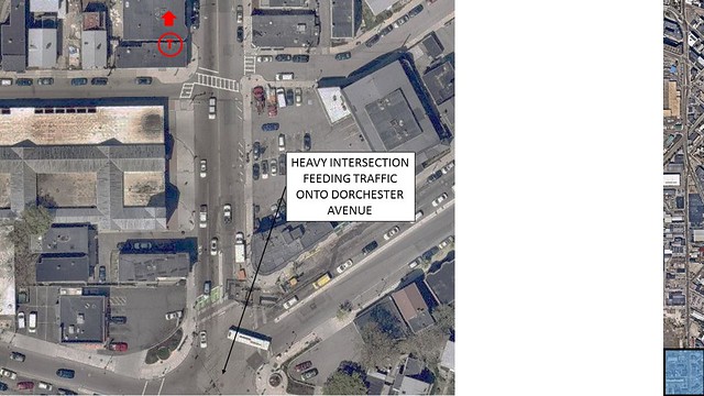
Figure 7: Callout 1
The highly industrialized area makes the street unattractive to bike along. The road is also very long and straight. Cyclists would not like to bike down an unattractive piece of road that such a long extent.
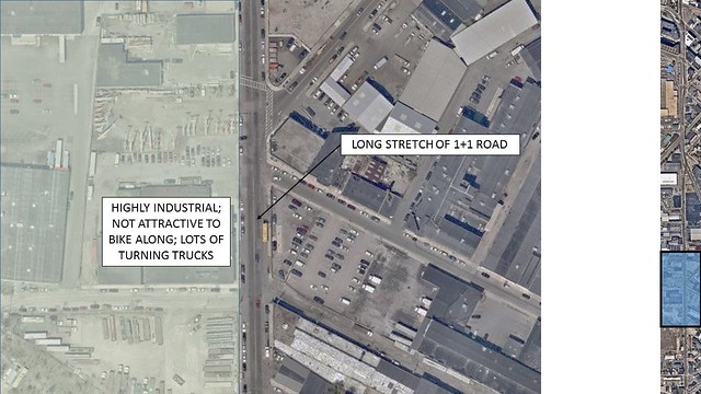
Figure 8: Callout 2
At the Old Colony Avenue/7th Street intersection, pedestrians and cyclists would have to cross 5 long crosswalks just to continue their journey north or south. A crossing should not be this complicated or dangerous. Furthermore, there is a bus depot entrance/exit where large buses would frequently turn in and out of. With large vehicles, safety is always important to consider. A bus service also travels on this portion of Dorchester Avenue.
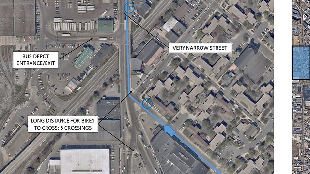
Figure 9: Callout 3
At the A Street intersection, there is a similar problem as with the one just before. There is an odd intersection with many crossings and traffic coming at obscure angles. It should be simplified for ease of use. Here, another bus line also travels down Dorchester Avenue.
At the West 4th Street intersection, there are long crossings for pedestrians and cyclists which we’d like to reduce to shorter if possible.
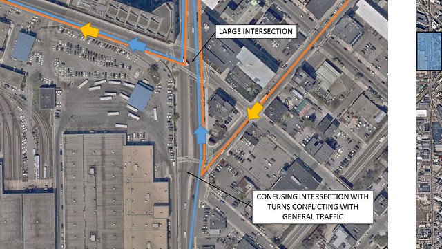
Figure 10: Callout 4
The West Broadway intersection in particular experiences heavy pedestrian traffic due to the Broadway T stop. This intersection could be a safety hazard to pedestrians and cyclists who need to cross two lanes of traffic on the eastern part of West Broadway. Furthermore, because one of the exits of the Broadway T station is on an island in the top left of the intersection, there could be a lot of pedestrians trying to cross this intersection on any given time, so safety is important.
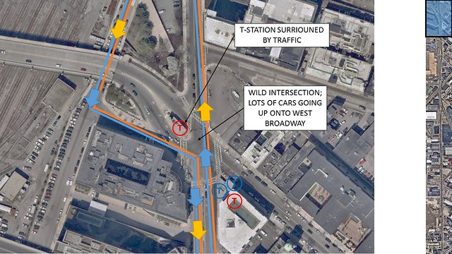
Figure 11: Callout 5
Major Intersections to Note:
– West Broadway
– West 4th
– A Street
– West 7th/ Old Colony Road
GOALS
We have two bicycle mobility objectives:
- Create Safe North-South Connectivity Route for Cyclists
Dorchester Avenue is a straight, direct route from South to North, which could connect the communities of South Boston, Dorchester, and Lower East Mills ETC. to the heart of Boston by bicycle. All are within a 7.5km span of Dorchester Avenue. This is important because, according to research, people are willing to commute by bicycle up to 7.5km.
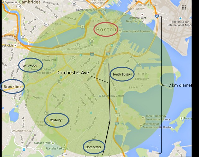
Figure 12: 7.5 km Map
Additionally in the 5 and 30 year Boston Bike plan there will be bicycle facilities that will help connect Dorchester Avenue to important destinations, such as the Seaport, South Boston and downtown.
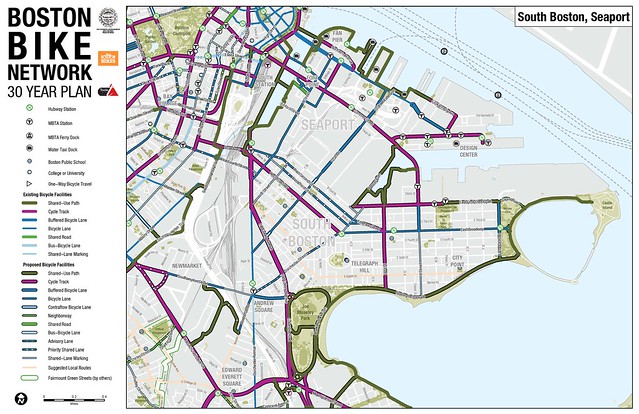
Figure 13: 30-year Bicycle Plan
- Connect Greenway
We want to connect the Joe Moakley Park and its bicycle trails to the Rolling Bridge Park by means of Dorchester Avenue because this is the most direct route.
Bonus: Dorchester Avenue is currently not an appealing place for cyclists to travel down. We would like to make it more attractive for cyclists by providing better facilities for cyclists, which includes cycle tracks, green space, and right-of-way.
PROPOSED DESIGN
Main Strategy:
In order to make this heavily used route better for cycling, we need to create the space necessary to have a cycle track throughout all of Dorchester Avenue, even where space is tight. On a road with traffic this heavy, that seems like the only type of solution that will make a bicycle commute appealing. At different cross sections we have found different ways of taking the space needed or adding green space to give the space a more lively, inviting feel. One of the main methods used to find this space is to remove on-street parking. While this is not desired in most cases, for Dorchester Avenue we felt this was possible. The reason for that is because most of the land use is industrial and manufacturing. There is a lot of empty asphalt spaces within each parcel. We believe that those using the on-street parking are mostly employees or visitors for those industrial and manufacturing companies. Because the companies have a lot of space though, we believe that they should utilize their private property for parking, as opposed to public space which could be better utilized. Thus, while our method is aggressive, it is justifiable.
The following roll plan gives an overview of our proposed design for Dorchester Avenue.
Cross Sections — Andrew Sq to Intersection 1
Starting from Andrew Station in the south and heading north, this is the current existing conditions on Dorchester Avenue between Andrew Square and Leeds Street, seen in the figure below. There are four 10’ travel lanes, two in each direction.
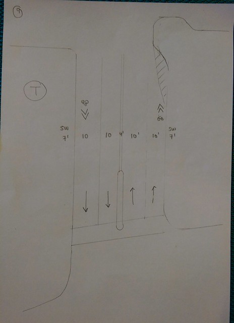
Figure 14
Our proposed design reduces the number of travel lanes to three in order to create space for cycle tracks.
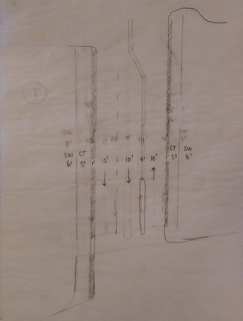
Figure 15a
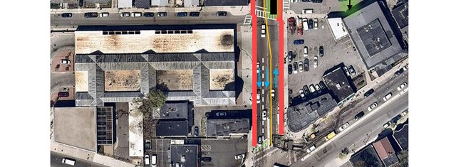
Figure 15b
We believe it is possible to remove one of the northbound lanes because (1) it merges into one lane anyway as seen in existing and (2) judging from the traffic counts provided, most cars in the lane feeding into the travel lane we are removing seem to turn right. Dorchester Avenue south is the one we are interested in for this count and it appears more people use the left lane for through traffic compared to the right. The left lane has more than double the number of vehicles. This leads us to believe the right lane is used mostly for right turns, whether onto Dorchester Street or Preble Street. Therefore if we make the right lane for ONLY right turns, we will only have one through lane feeding into Dorchester Avenue north. This makes it possible to take away one lane, giving us space for a cycle track.
Also, in anticipation of the future, if we wish to continue a bicycle network through all of Dorchester Avenue down to the south, a cycle track will be needed on Dorchester Avenue south of Andrew Square. Since there is currently 2+2 lanes at the south side of the intersection, one lane would potentially need to be removed in order to create space for a cycle track. That would reduce the feeding lane into Dorchester Avenue north only one.
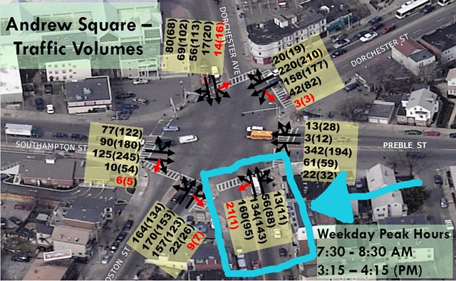
Figure 16: Traffic Counts
From Leeds Street to Algers Street, this is the existing cross section.
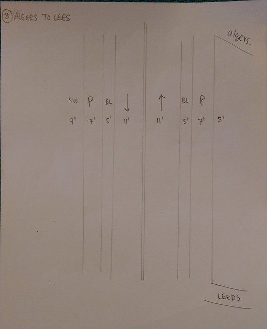
Figure 17
This section of Dorchester Avenue has industrial areas on the left, and manufacturing with a few commercial areas on the right. Since most of the industrial left side has their own parking lots, we decided to remove on street parking in order to create space for cycle tracks. On the right side though, not every store has a parking lot. Therefore we decided to keep parking. Below is the proposed cross section.
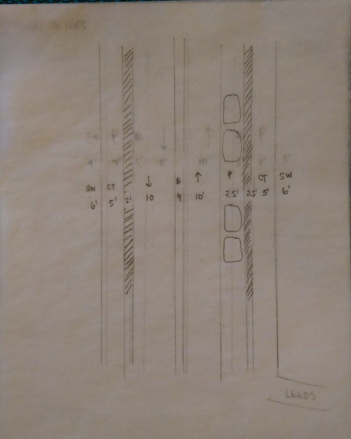
Figure 18a

Figure 18b
We redistributed the space from one parking lane (7’), two bike lanes (10’), and reduced the travel lanes from 11’ to 10’ (2’) to create space for 5’ cycle tracks with 2-2.5’ buffer zones. Parking on the commercial right side has been shifted so that the cycle track is next to the sidewalk. We also propose a mountable buffer between the travel lanes to be consisted with the rest of the street, which you will see as we go on.
From Algers Street to D Street, we are proposing essentially the same layout as previous stated. Below is the existing followed by the proposed design.
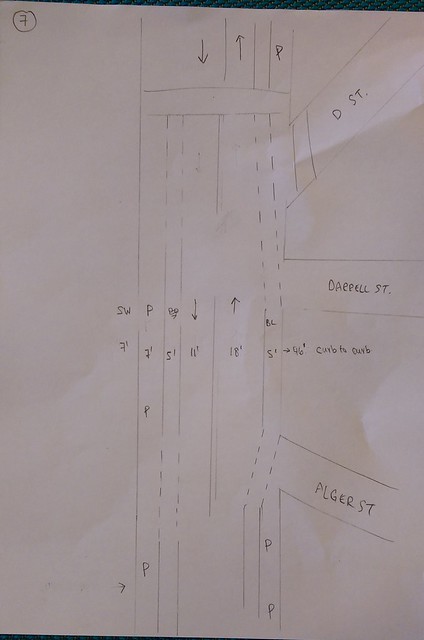
Figure 19
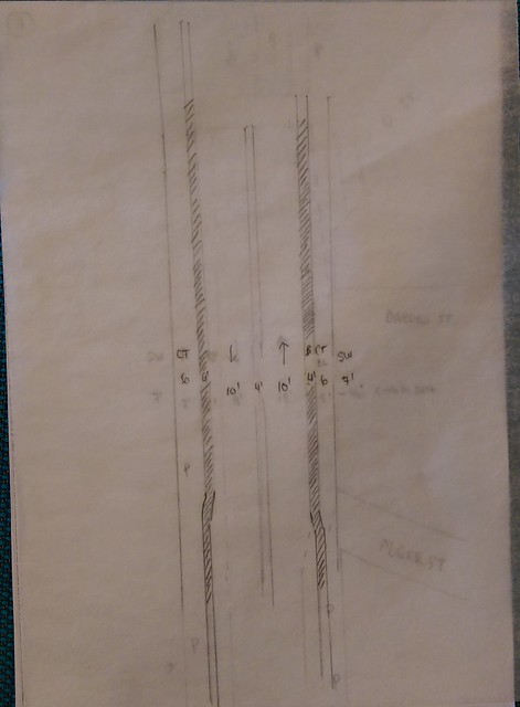
Figure 20a
Figure 20b
We are once again removing parking from the left side, which is industrial areas with their own parking lots. The right side did not have parking at all, which worked to our benefit. To keep the street consistent, we have 10’ travel lanes with a 4’ mountable buffer in the center. But because we have more space to work with here, we increased the cycle track to 6’ and the buffer zone to 4’.
From D Street up to Intersection 1, the existing conditions have one lane in each direction with parking on both sides. Parking on the right ends however and becomes a second through lane. The existing bike lane also ends and becomes a sharrow.
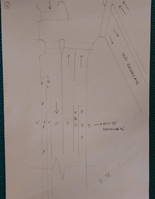
Figure 21
Dutch standards never have sharrows though, so neither does our design. We propose a removing parking on both sides, as this area is industrial/manufacturing on both sides, with private parking areas. Without the parking, we now have space for one-way cycle tracks on both sides.
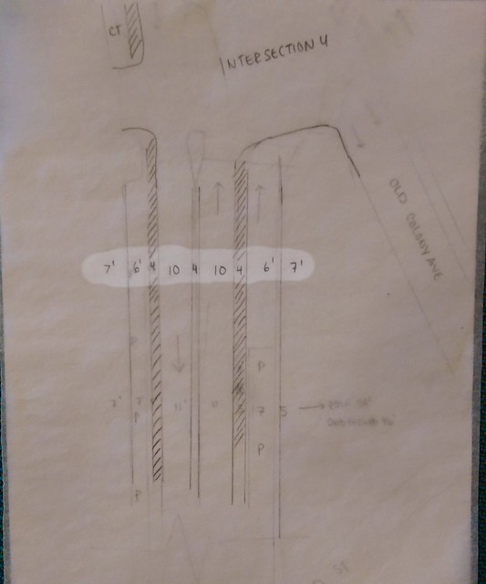
Figure 22a
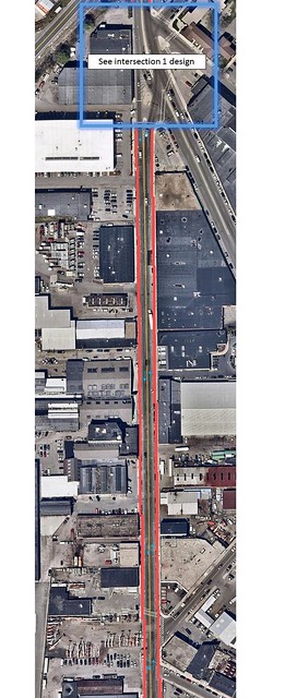
Figure 22b
After this section came our first major intersection, Dorchester Avenue & Old Colony Road. We took into consideration that taking away a lane at the intersection would impact its capacity, especially during the AM peak hours when there is the most northbound traffic. However, if there IS a need for a second lane, we propose the cross section below at the intersection to accommodate a second lane.
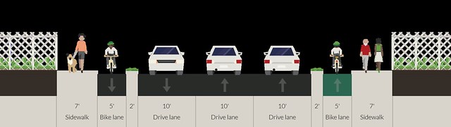
Figure 22c
Intersection 1
The first major intersection coming up from Andrew’s Square is the one at West 7th Street and Old Colony Road. This is currently a signalized intersection with cars merging from Old Colony Road onto Dorchester Avenue. There are many crosswalks and the easiness of a pedestrian or cyclist traveling south to north or vice versa is difficult and dangerous. Pedestrians would have to cross five crosswalks and cyclists would have to be exposed to traffic for an extended period of time if they were traveling north south.
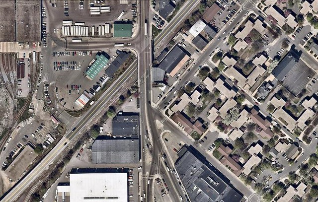
Figure 23: Existing
Our solution is to make a signalized intersection but simplifying it down so that it is easier and safer for pedestrians and cyclists to travel while maintaining the flow of traffic. Green space would be reclaimed in one area by removing a crossing. This space is also used to straighten out Dorchester Avenue. Cyclists can also ride north along this green space with more comfort because they wouldn’t be as exposed on both sides as they are in the existing condition. When crossing two way streets, there would be a pedestrian island for pedestrians and cyclists to wait so that they only have to pay attention to one direction of traffic at a time. A “No Left Turn” sign would be placed for Old Colony Road so that cars cannot turn southbound onto Dorchester Ave. Should cars be allowed to do so, it would impede traffic flow because the majority of the flow is going northbound and giving that turn a signal of its own would waste a lot of time. The existing conditions also prevent this turn with an island.
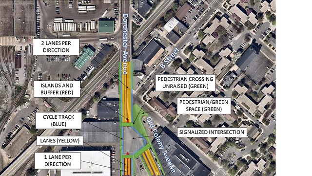
Figure 24: Proposed
Cross Sections — Intersection 1 to Intersection 2
From the intersection to Haul Road, the only bicycling infrastructure are sharrows.
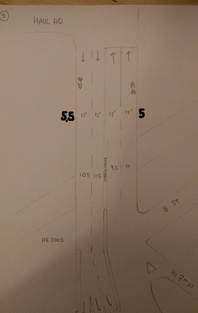
Figure 25
To make the street have adequate cycling infrastructure, we propose making the travel lanes 10’, which creates 4’ of space on both sides of the road. The existing sidewalks are currently about 5’ so if we were to combine the sidewalk and 4’, there could be 9’ of sidewalk on both sides. Using this 9’, we propose a 4’ sidewalk directly next to a 5’ cycle track.
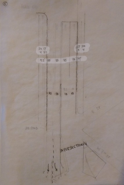
Figure 26
While this situation is not ideal and more space is preferred for a cycle track and sidewalk, we are constrained by the fact that this section of Dorchester Avenue becomes an overpass for the South Boston Bypass. Thus, we believe this is the best solution possible to achieve our goal. Few pedestrians walk in this section of Dorchester Avenue because it is industrial. There are no commercial or recreational facilities here. Therefore there should not be much conflict between the occasional pedestrian and cyclists.
We also gave more space to the cycle track instead of the sidewalk because (1) we are not expecting many pedestrians to be using this section and (2) the cyclists will be right next to the travel lane so 1’ of the cycle track becomes a buffer zone and effectively not used.
The next section is from Haul Road to Intersection #2. There is an existing bike lane on the left side and a sharrow on the right. The land on the left side is for an MBTA bus depot, while the right is a small commercial area with a non-chain version of Dunkin Donuts and a few restaurants.
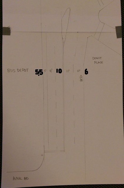
Figure 27
This section is very narrow, as there is only a 5.5’ and 6’ sidewalk on the left and right, respectively. There was no parking space to remove in order to create space, but our proposed design managed to squeeze in our design goals of having raised cycle tracks. The proposed design is similar to the section before, with a 4’ space for pedestrians and a 5’ space for cyclists.
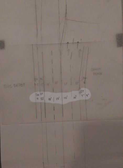
Figure 28a
Figure 28b shows the roll plan section for both Figure 27 and 28a
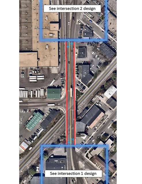
Figure 28b
After this section was our next major intersection, Dorchester Avenue & A Street.
Intersection 2
The second intersection is with W 5th Street and A Street. It currently is a signalized intersection with two medians in the middle that prevent cars on W 5th Street from turning left onto Dorchester Avenue. It also prevents cars on Dorchester Avenue from turning on to W 5th Street.
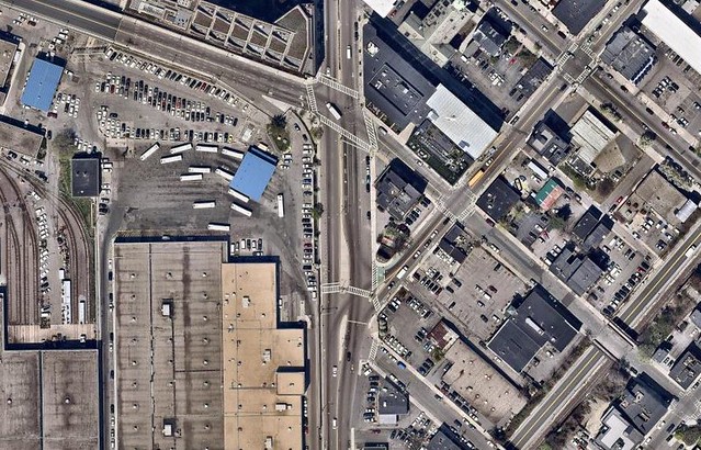
Figure 29: Existing
We considered getting rid of the signals at the intersection so that cyclists do not have to wait in order to continue on Dorchester Avenue. We thought of putting yield signs for right turns, similar to what the Dutch have in place. The Dutch also use raised crossings in order to provide some vertical deflection and to get the attention of car drivers as seen in Figure 30. However, we will keep this intersection signalized and not raise the crosswalks so that cars can clear out from the area as quickly as possible – it is a heavily used avenue with heavy traffic volume. Therefore, keeping it signalized and leaving the crosswalks unraised would be the solution that we will go with in the interest of capacity. Furthermore, we are connecting the two medians in order to make one larger, 17’ median. This will block cars going southbound on Dorchester Avenue from turning left on to A street or W 5th Street, which are currently rare turns (and turning left that can easily be accomplished elsewhere). This simplifies things and keeps traffic flowing, and it provides for a refuge island for pedestrians crossing Dorchester Avenue. Furthermore, we decided to extend the curb at the corner of A Street and W 5th Street, and have the cycle track continue at least a few feet into A Street, until it becomes a lane again. This is in order to make for a sharper right turn for cars, who are thus forced to meet crossing pedestrians at a 90 degree angle (which increases awareness and safety). We are not as concerned with pedestrians crossing one street below, on W 5th Street, because of the infrequency with which cars turn right at that street.
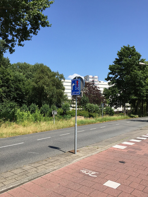
Figure 30: Dutch Inspiration
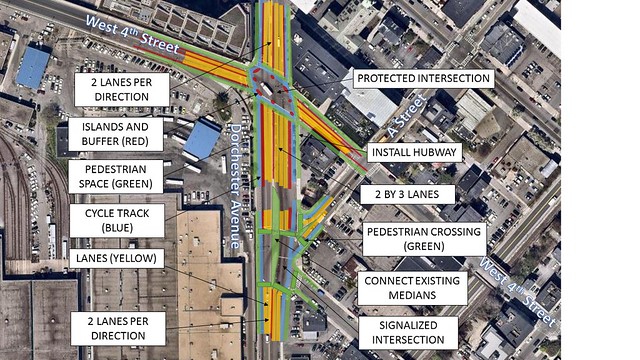
Figure 31: The lower intersection is the proposed intersection 2
Cross Sections — Intersection 2 to Intersection 3
The section between intersection 2 and 3 is a short section, but a very wide section. Currently, on the left side there is a bike lane with a buffer and two southbound lanes. On the right side are four northbound lanes with a pocket bike lane and parking.
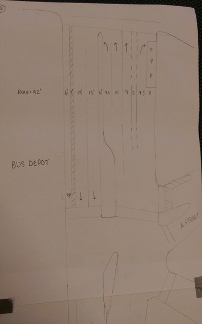
Figure 32
We first tackled the left side and proposed a raised cycle track in place of the bike lane. We also reduced the travel lanes from 13’ to 10’. With this extra space, we propose a 7’ cycle track with a 8’ buffer zone. In this buffer zone because it is rather wide, we hope to create a green space by planting trees, installing planter boxes, or other methods. Because the existing southbound travel lanes taper to 11’ as it approaches intersection 2 however, the buffer zone will also taper to 5’.
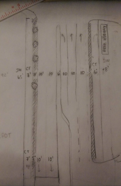
Figure 33a
Figure 33b
On the right side, we decided to remove the right turn lane because we do not believe motorists uses it enough to grant right turns their own lane. Motorists traveling northbound on Dorchester Avenue would take the right before because it is a more gentle turn and a more direct path. The northbound right turn at W 4th is very sharp so we do not believe many use it. It is only there because there is extra space in the intersection.
What we aim to do is to take this extra space, along with space from the 3 parking spots and using it for a green area. We propose keeping the left turn lane and two travel lanes, and setting each at 10’ wide to help normalize them. Currently they are 9.5’, 10’, and 9’ respectively. Then we plan to bump out the sidewalk 8’ and have a 6’ cycle track next to it with a 3’ buffer on the street side. The extra sidewalk space could potentially be used for a hubway station because there is not one nearby, and to promote cycling!
Intersection 3
Currently, the intersection of West 4th Street and Dorchester Avenue is a large pedestrian crossing with four and five lanes of traffic going north south and three lanes of traffic going east west. It is a very busy intersection with a hefty amount of traffic. This can pose dangers to pedestrians and cyclists crossing the wide intersection.
Figure 34: Existing
We propose making this intersection protected to keep the pedestrians and cyclists safe. A protected intersection is a Dutch method to separate fast moving traffic with slow moving traffic. The protected intersections have a vertical barrier and ensures that cars are facing the pedestrians in the crosswalk when they turn to avoid accidents such as a right hook.
Figure 35: Proposed
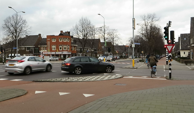
Figure 36: Dutch Inspiration
Cross Sections — Intersection 3 to Intersection 4
Currently, the section between W 4th Street and W Broadway has a typical section of two travel lanes with sharrows on the outer lanes and parking on both sides. There is also a bus stop on the corner by the Broadway T Station. The land use consists of a mix between residential and commercial.
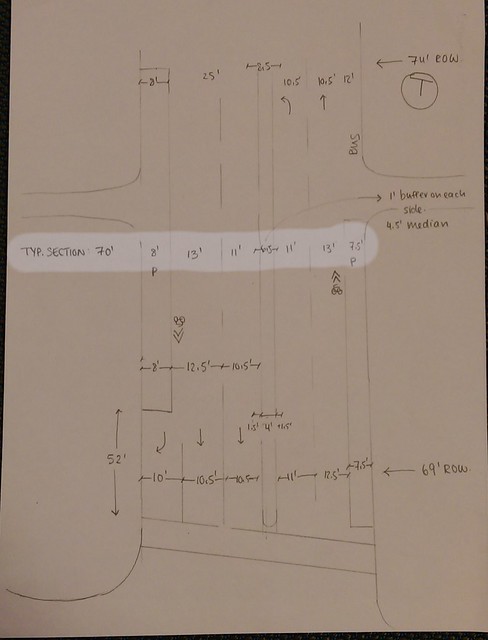
Figure 37
In order to create space for cycle tracks on both sides, we propose removing parking in on the right side. Currently, there are approximately 6 spots in front of an apartment complex. Since the apartment has a parking garage around the corner, we believe removing these spots will not have a major negative impact. This allows us to bumpout the sidewalk on the right and install a 6’ cycle track with a 2’ buffer zone.
Figure 38a
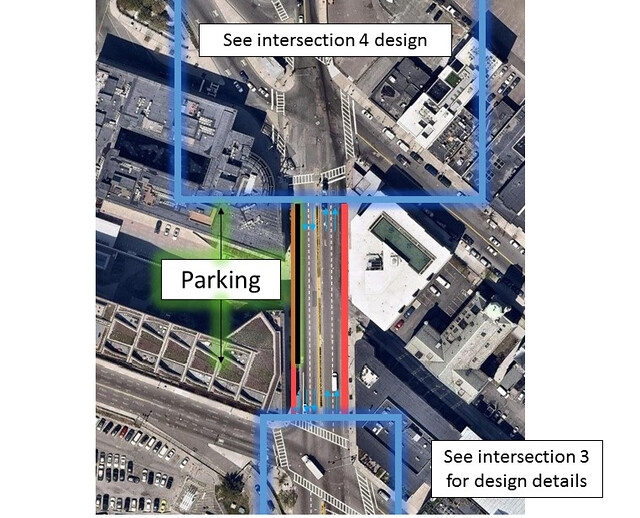
Figure 38b
On the left side, we decided to keep the parking so people can access the local businesses on the ground level of the apartment complexes. By reducing the travel lanes to 10’ each, we were able to also install a 6’ cycle track with a 2’ buffer zone on the left side.
As for the bus stop next to Broadway Station, we decided to remove its bus bay and have a cycle track installed. When buses have to pick up passengers, they can stop in-line with the travel lane. This is possible because one lane is for left turns and one is for through. The majority of traffic will be taking the left turn onto West Broadway so the buses should not delay a large amount of traffic.
This brings us to our final intersection, West Broadway.
Intersection 4
Currently the broadway intersection is very messy with the western part of Broadway joining the intersection at a slanted angle, facilitating fast turns for cars that are East Bound Right onto Dorchester Avenue. Another undesirable and unsafe feature is the Broadway T exit which is in the middle of the intersection. Pedestrians are crossing here all the time due to the T, and the 9 bus stops a little down Broadway avenue to the left. Additionally we were having difficulties trying to plan for coordinated traffic signals due to the slanted angle of the intersection (at some turns cars could risk clipping each other).
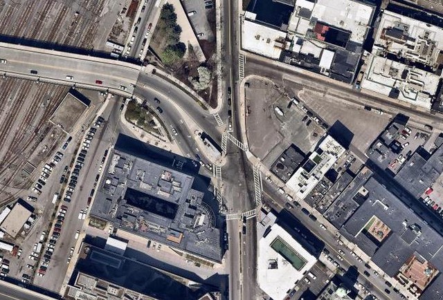
Figure 39: Existing
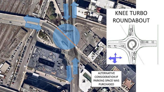
Figure 40: Option 1
Our first option was to implement a knee turbo roundabout in the intersection to better the flow of traffic and improve the intersection. If land were to be purchased from the parking lot, there would be at least 200 ft in diameter of space available to build the roundabout. The knee turbo roundabout is selected because traffic is heavy on the south and west leg, whereas regular turbo roundabouts are better for traffic flowing in a straight line. However, this option was not very effective because not all streets can come into the knee turbo roundabout at 90 degree angles and it is not very safe for pedestrians and cyclists to cross; there are too many streets coming in for the roundabout to deal with. Furthermore, there is a T station entrance/exit that would have to be relocated. This is why we went for another idea.
In order to tackle all of these issues, we decided to straighten out the western part of W Broadway by converting the existing upper greenspace into road where needed. This will make for a more perpendicular connection with Dorchester Avenue, causing sharper (thus slower and more careful) turns, and make coordinated light signals possible. The old part of W Broadway that used to lead into Dorchester Ave will be converted into greenspace (to compensate for the green space taken away), which will also connect the existing T exit to the green space to the left. This will make it a bigger, safer, and more pleasant pedestrian area.
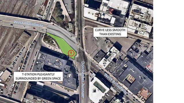
Figure 41: Option 2
For this intersection we decided to follow the example of Dutch intersections that have a traffic signal ring structure for fully protected movements. The main routes cyclists are interested in is continuing South or North on Dorchester Avenue and taking a left on to Broadway. Greenbaum Street is a one way street used almost exclusively by buses, and is therefore a street that carries barely any traffic, so we decided to give traffic from this lane priority signaling that is only triggered when a sensor emitting a signal when buses are coming through. These would be the traffic signal phases:
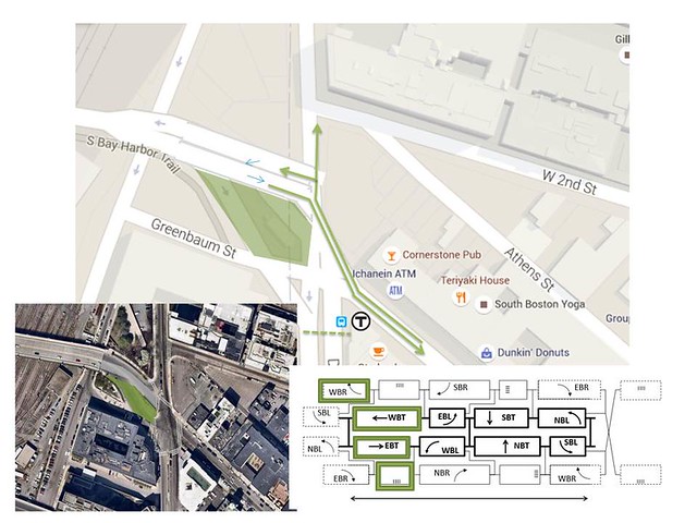
Figure 42: Signaling
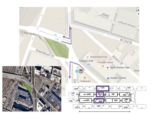
Figure 43: Signaling
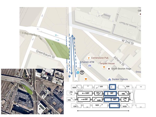
Figure 44: Signaling
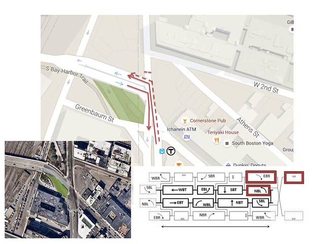
Figure 45: Signaling
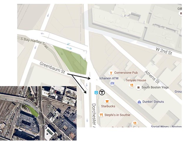
Figure 46: Prioritized Signal Phase for Buses:
CONCLUSION
With our improvements, we satisfy our goals of connectivity and safety; and the bonus of making the street more appealing for cyclists. Commuters in the 7.5 km radius now have a cycle track to travel into metro Boston; the various communities are more connected. Not only is the route to metro Boston direct, but it is also safe and pleasing to ride down with the additional green space that was added to various segments of the trip. There are no more sharrows, no fighting trucks, no superfluous space from wide streets, no unnecessary parking, and no useless pocket right lanes. The route is easy to use, safe, and still carries the flow of traffic as it originally did.