Team: Anna, Chase, Peter, Tiffany
Ring Road (East)
The binnenring is a bike oriented road on the inner border of the historical district of Amsterdam. It is parallel to the singelgrachtroute, which is a motor-oriented road on the outside of the historic district. While each accommodates cyclists and motorists to an extent, it is clear that the roads are designed for separated functions. The binnenring is designed to keep cars at low speeds to create a safer environment for cyclists. Some of the traffic calming techniques used are alternating one ways which prevent through traffic, smaller lanes to force cars to slow their speed while passing cyclists. The section of the binnenring our group visited can be seen in Figure 1 below.
Figure 1: Locus Map of Binnenring
We started our tour right after Frederickplein and headed east to Weesperplein. The cross section for this part of the road can be seen below in Figure 1. On the south side of Sarphatistraat, it is not very stressful for cyclists as long as there were not many vehicles passing them in the travel lane. For the north side however, because the cyclists were right next to the tram tracks, cycling could be stressful when a tram passes. When there wasn’t however, the north side experienced low stress since there was no through traffic alongside the bike lane. Any local traffic that had to cross the bridge would have to drive on the tram tracks.
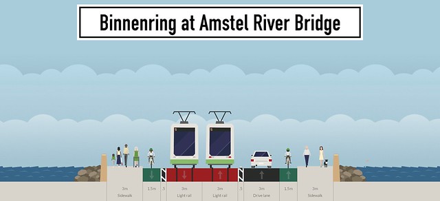
Figure 2: Cross Section A — the Binnenring at the Amstel River Bridge
At the intersection of Sarphatistraat (the binnenring) and Weesperplein, the bike lane becomes a cycle track. The bike lane gets elevated to sidewalk level and a buffer zone of trees is placed between the cycle track and the road. This reduces the stress at the intersection, particularly since the travel lane is forced to turn either left or right. Cyclists are now protected from motorists and do not have to worry about a right hook as they have their own phasing.
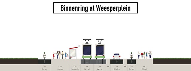
Figure 3: Cross Section B – Binnenring at Weesperplein
At the intersection, the street becomes one-way for vehicles on the north side while the south side has no through traffic for cars but allows transit and bikes to continue through, as seen in Figure 4A below.
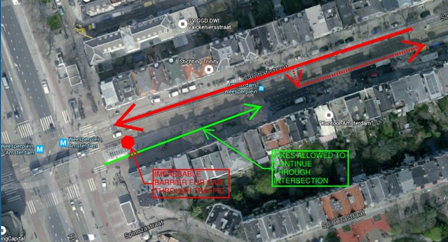
Figure 4A. Section C Weesperplein to Plantage Middenlaan
A few hundred feet after the intersection the road allows traffic in both directions, however due to the intersection stopping through traffic only local residential traffic travels eastward, seen above as dashed lines in figure 4A, which does not have high turnover. See street cross section in Figure 4B below. For this section of street from Weesperplein until Plantage Middenlaan, there is very low stress from cyclists because there was low traffic. This allows cyclists to pass those slower than themselves with ease because there are no cars constantly passing, in turn allowing a higher number of cyclists to use this portion since cyclists can cross into the car lane as necessary. The tram tracks are also elevated a few inches from the vehicle and cycle lanes, creating a buffer zone to help prevent cyclists or cars from accidentally mounting the track area. This further reduced the stress on cyclists.
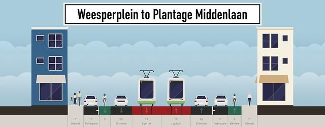
Figure 4B. Section C Weesperplein to Plantage Middenlaan
Something interesting about the south side at this location is that the curb bumps out further than the parking lane. Because of this, there are pavement markings on the ground with arrows that seem to direct cyclists around and away from the curb to make sure they do not hit it. These bumped out curbs whole purpose seems to be to give the trees enough space to thrive, however instead of giving the extra space between trees to parking they make sure it is known that extra space in-between trees is for bicyclists with paint.
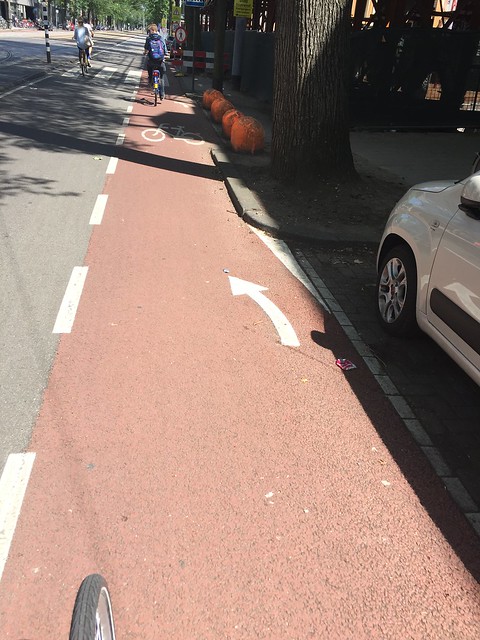
Figure 5: Interesting Pavement Markings
When the street approached the intersection of Plantage Middenlaan, the bike lane was once again protected and had their own phase away from vehicular traffic. From Plantage Middenlaan to Hoogte Kadijk, the street had only one travel lane on the south side. The bike lane raised 2-3 inches from street level,separating it from the travel lane. This created a low stress environment for cyclists as they had a physical form of separation from vehicular travel. On the north side, there was a bike path, allowing the cyclists to be even less stressed. This section can be seen below in Figure 6 and was definitely a bike friendly area. There was even grass growing on the train tracks!
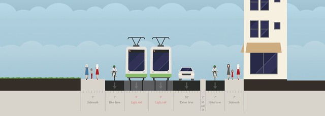
Figure 6: Section D – Plantage Middenlaan to Hoogte Kadijk
From Hoogte Kadijk to Zeeburgerstraat, the street became more motor oriented, with one travel lane in each direction. To reflect this change, the bike lanes became protected cycle tracks, separated by an approximately two foot raised buffer zone from vehicular traffic. Since there were one-way cycle tracks, this made it safer for cyclists compared to them biking in the street and kept a low stress environment for cyclists.
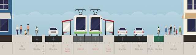
Figure 7: Section E — Hoogte Kadijk to Zeeburgerstraat
Intersections
On the main route for bikes, there were only three major intersections. In the first intersection (Figure 8 below) we can see some typical dutch protected-intersection features. There is an offset between cyclists and motorized vehicles. The stop line for the bicycles is further up than that of cars, putting cyclists in the view of motorists.
Figure 8
Cyclists also have their own stop light, which is near side and has the common “wacht” count down (Figure 9).
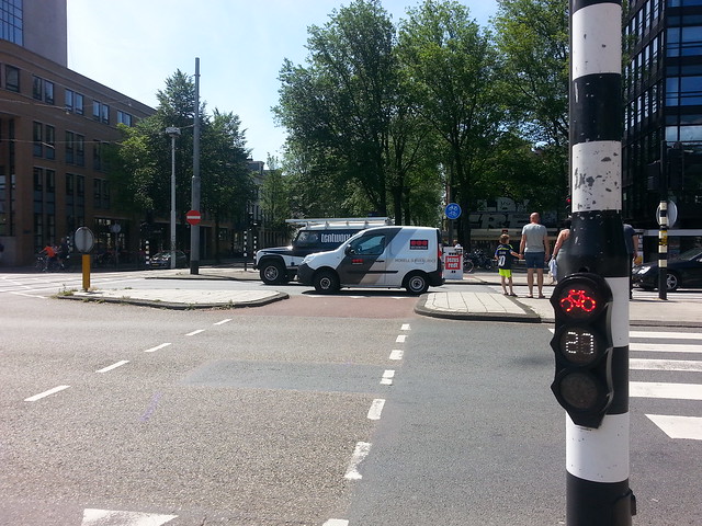
Figure 9
There are Refuge Islands for pedestrians and cyclists. These are definitely necessary for this intersection there are two lanes of tram tracks as well as a travel lane to cross. Most importantly, at this intersections, cars cannot continue eastward along the Binnenring, but rather are forced to take a right or left turn. The car lanes abruptly end, and then pick up again just as suddenly a little past the intersection to allow residents access to parking (Figure 10).
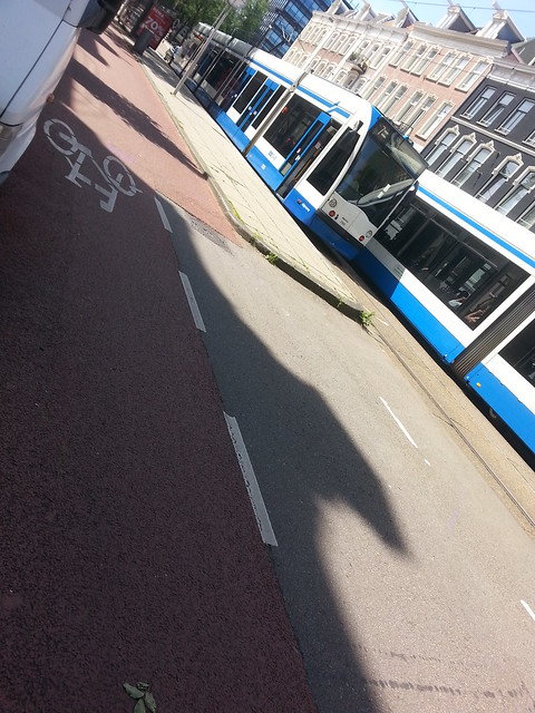
Figure 10
In the second intersection (Figure 11), the buffer separating the cycle track is not quite as large, and you can more clearly see the impact the tram-curves have on the street; due to the wider turn radius required by the trams, the intersection is forced to be much larger than it would be otherwise, eating away at what could perhaps otherwise be buffer space or greenspace.
Figure 11
Below is another intersection, this time on the car-oriented side of the Binnering (the east portion of which consists mainly of Mauritskade). This intersection features an offset for the bicycles, however we found the temporary little mound of asphalt acting as a buffer to be amusing (it can be seen behind the stop light in the Figure 12).
Figure 12
Here is another intersection further westward on the main route for cars (Figure 13):
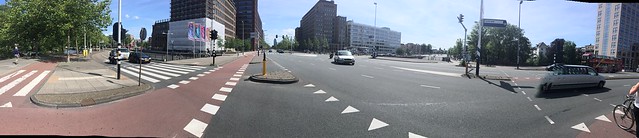
Figure 13
As can be seen in this last intersection, there is more than one lane of car traffic for each direction. Additionally, on the car side of the Binnenring, cars have right of way and do not need to yield to bicycles.
Binnenring vs. Auto-Oriented Road
On the Binnenring, there are 3 intersections with traffic lights. The car-side of the Binnenring, the Mauritskade, had 4 intersections with traffic lights. The flow of traffic was faster for cars on the Mauritskade, and it took much longer for pedestrians and cyclists to cross to the other side of the road because cars were much less willing to stop. It was clear that they dominated the traffic. Heading west, there was only one lane for each traffic direction for cars up until Alexanderplein, where the tram takes a right and no longer continues on Mauritskade. This frees up space for car lanes, so further down along Mauritskade we have a 2 + 2 car lane configuration. While both sides of the Binnenring feel safe, it is less convenient for bicycles to travel on Mauritskade compared to Sarphatistraat, due to priority given to cars and an additional intersection.