Design Project #1: Minot Street
Team: Matt, Kyle, Caroline, and Tiffany
Background
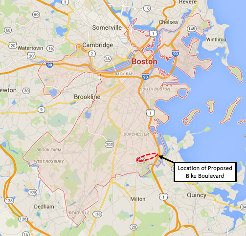
Currently, Boston’s bike network is very fragmented and disconnected. The existing infrastructure consists of stand-alone paths that usually do not connect to other bicycle facilities. In the Adams Village neighborhood of Dorchester, there is no continuous bike network to get from one side of the village to the other. Gallivan Boulevard, the main east-west route in the village, is a major roadway that is not suitable for high volumes of bike traffic. Minot Street, which runs parallel and to the north of Gallivan Boulevard, has the potential to be transformed into a major bike route running from Neponset Avenue in the east to Lower Adams Street in the west, with connections to the Neponset River Trail. The Neponset River Trail runs south of the residential and commercial districts of Adams Village, and does not provide direct connections to many destinations in the village. Figure 1 shows the location of Minot Street and Adams Village within the City of Boston.
Figure 1. Locus Map
Minot Street through Adams Village is a residential street parallel to a major collector street, Gallivan Boulevard. Because of its proximity to Gallivan Boulevard, cars often cut through Minot Street to avoid traffic. The neighborhood has put in efforts to prevent this by making certain sections of Minot Street flow one way, and other sections the opposite direction, reducing its attractiveness to through traffic. These traffic calming measures show that the residents support limiting through vehicular traffic on the street. The lack of through traffic makes this an ideal location for a bike boulevard, as it provides a relatively direct route for bicyclists that does not have heavy car traffic.
The idea of a bike boulevard is one that is borrowed from many European street designs and is extremely popular in the Netherlands. The Dutch refer to the practice of separating through bike and vehicular traffic on separate roads as “unbundling”. Names for this facility vary wildly around the world; in London this would be referred to as a “quietway”, while in Boston the term “neighborway” has been coined. Other cities in the U.S. prefer “greenway”, but for the purposes of using the most commonly used term, “bike boulevard” will be used for the rest of this report.
While Minot Street has the potential to be turned into a bike boulevard, there is one thing that currently is preventing through bike traffic: one-way directional signs. Minot Street has several one way sections where currently both vehicular and bicycle traffic must follow the one-way traffic laws. This alternating one-way traffic flow has made biking more dangerous, as it forces through bike traffic to travel on busy Gallivan Boulevard. In order for Minot Street to accommodate more bike traffic, cyclists need to be able to travel contraflow to vehicular traffic. There is currently only one block in the City of Boston that allows contraflow bicycle traffic, so the idea of contraflow is still somewhat radical in the area. Allowing contraflow bike traffic is a main component of the bike boulevard and must be carefully designed in order to limit confusion among residents of the neighborhood.
Two very valuable opportunities to increase bicyclist safety will be taken advantage of with the creation of this bike boulevard; the complete separation of the main car and bike routes in the area, and the maximization of the already existing space by simply giving bikes the legal ability to travel in both directions while keeping car traffic limited without many changes to the existing infrastructure.
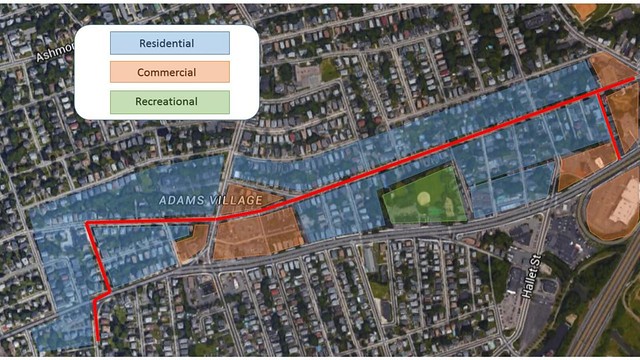
The existing land use in the neighborhood and along Minot Street is mainly residential, with some commercial land use in mixed in. Commercial land use along Minot Street is limited to the area near the intersections of Minot Street with Adams Street and Neponset Boulevard. The neighborhood land use is exhibited in Figure 2.
Figure 2. Land Use of Surrounding Area
Goals of Redesign
The goal of the redesign is to create a low stress connection between two sections of the Neponset River trail, a long existing bike trail that goes along the Neponset River in Dorchester and connects to the Boston Harbor Trail which goes to Castle Island in South Boston.
To create an enjoyable and stress free experience for cyclists along Minot Street, our design has four goals:
- Low traffic – To allow bicycles to comfortably bike along Minot Street we want to reduce traffic as much as possible. By making the road unattractive to through-traffic, we hope to reduce traffic to only local traffic. This will also get rid of motorists who want to speed through the area, disturbing the neighborhood.
- Low speed – For bicycles to safely travel in a road with cars, the street must have a low speed limit. A low speed allows bikes to comfortably share the road with vehicular traffic. Low speed must be achieved using methods that reduce vehicular speed without impeding bicyclists.
- Safe intersections – Any intersections along the proposed bike route must be designed with bicycle safety in mind. Designated bicycle waiting areas, refuge islands (if necessary), and bicycle crossing signals will allow bicyclists to safely cross traffic.
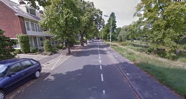
- Contraflow bike facilities – The main bike path will be made unattractive to vehicular traffic by breaking it into multiple short one way roads. By allowing bicycles to bike against traffic on one way roads the street will become an attractive bike route while reducing vehicular through traffic. This method of allowing bicycles to travel in the opposite direction of traffic is common in the Netherlands as it allows you to create quiet neighborhood streets that are extremely attractive to cyclists to use as a through road. A good example of this is Weteringlaan in Delft, the Netherlands shown in Figure 3 below. Wateringlaan is one way for vehicular traffic but allows bike traffic in both directions and has an advisory bike lane in the contraflow direction. This is a common setup in the Netherlands for one way residential roads that do not experience heavy vehicular traffic and a method we hope to import to Minot Street in Dorchester.
Figure 3. Contraflow bike facilities on Weteringlaan in Delft, the Netherlands
A side goal of this redesign is to allow the residents of the streets to enjoy their neighborhood again and not see it as a dangerous place to be. Through achieving the goals of creating an enjoyable experience for cyclists, we are also doing the same for residents. Low traffic and speeds allow children to play in the streets again without worrying about getting hit by traffic and Residents can walk along the street without seeing or hearing motorists speeding through the area.
Existing Conditions of Roadways and Proposed Solutions
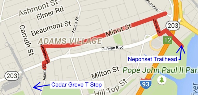
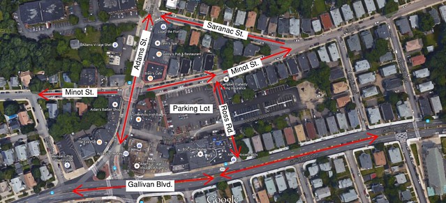
The scope of work for the proposed bike boulevard includes Minot Street from Neponset Avenue to Fredericka Street, Clover Street from Minot Street to Gallivan Boulevard, and Fredericka Street from Minot Street to Gallivan Boulevard. The scope also includes the areas surrounding the intersections of Minot Street with Neponset Avenue, Clover Street with Gallivan Boulevard, Minot Street with Saranac Street, and Adams Street with Gallivan Boulevard. The connection down Clover Street across the intersection with Gallivan Boulevard will provide a safe connection to the Neponset River Trail and will allow bicyclists to avoid the busy Neponset Circle intersection. Additionally, Neponset Avenue has existing bike lanes in the northern direction, allowing for increased bike connectivity with Minot Street. Figure 4 displays the limit of work for the proposed project.
Figure 4. Proposed location of bike boulevard with connections to Adams Street, Neponset Ave, and the Neponset River Trail
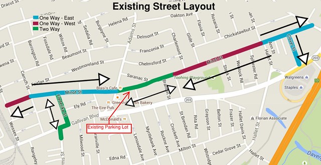
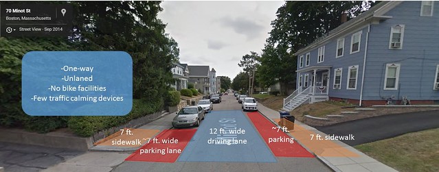
Minot Street is a residential street with typically one travel lane and parking on both sides. The street itself has no horizontal deflections except a very slight turn at Ross Road. Therefore it is very straight, making it ideal for higher travel speeds. Minot Street is paved with asphalt and has no pavement markings except for pedestrian crossings at Neponset Avenue and Adams Street. Traffic control devices consist of stop signs at larger intersections (Neponset Avenue, Adams Street), do not enter signs when the street changes direction, and a few “slow” signs. Current traffic calming measures include reversing one-way streets, as shown in Figure 5 below.
Figure 5. Existing Street Layout
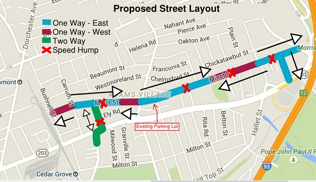
Using the four design criteria listed above, our first design featured wide advisory bike lanes that dominated most of the road. Advisory bike lanes are a common device used in the Netherlands and allow bike lanes to be implemented in low traffic roads that are otherwise too narrow for designated bike lanes. Advisory bike lanes designate bike lanes on either side of the road and leave a smaller vehicle lane in the center. This allows vehicles to travel down the road but encroach upon the bike lane when they need to pass another vehicle going in the opposite direction. However, upon further discussion and design, advisory bike lanes were deemed unnecessary for this location. Advisory bike lanes were deemed unnecessary because we determined that a bike boulevard could be designed by using a more appropriate design that causes less of an impact on the infrastructure of the street. A boulevard could be designated without adding unnecessary striping. This lead to design #2, the “Bicycle Boulevard” design where the through-traffic is eliminated, making the road attractive for bicycle-through-traffic and unattractive for vehicular-traffic. Figure 6 shows our proposed street layout for the bike boulevard, showing all one-way sections for vehicular traffic and the locations of all proposed speed humps.
Figure 6. Proposed Bike Boulevard Street Layout
A two pronged approach of one way streets and speed humps were used to reduce vehicular through traffic while still keeping the road attractive for bicycle through traffic. We propose reversing the traffic flow direction of two sections of Minot Street, illustrated in Figure 7 below. Changing the direction in which traffic is traveling frequently along this street should be an effective traffic calming device, as we learned from current design practices in The Netherlands.
Figure 7. Proposed Direction Changes along Minot Street
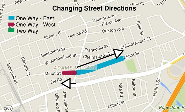
With the two directional reverses shown in Figure 7 above, Minot Street now has a maximum vehicular through distance of 5 blocks, making it unattractive for anyone hoping to use it as a shortcut to avoid Gallivan Boulevard, but still allowing residents to access their homes. By allowing contraflow bike traffic along Minot Street, bikes will have an attractive through street for bikes with minimal vehicular traffic.
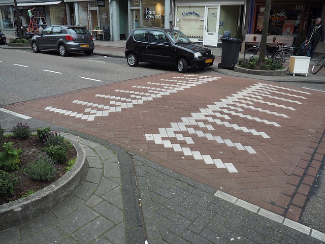
In addition to the direction reversals to reduce vehicular through traffic, we propose the use of speed humps to reduce the vehicular speed along the road. Figure 6 above shows the proposed locations of speed humps located roughly mid length along each span of same direction road. We propose the use of large, gentle speed humps instead of the steeper speed bumps commonly seen in private parking lots in the United States. The speed humps will reduce vehicular traffic to approximately 10-15 mph while still allowing cyclists to maintain a comfortable riding speed. Figure 8 shows speed humps commonly used in the Netherlands that force vehicles to slow while not affecting bicyclists.
Figure 8. Dutch Speed Hump Inspiration
These speed humps will prevent any vehicles from gaining too much speed along the one way road and will help to ensure that the route provides a low stress cycling experience. Additionally, as the proposed speed humps do not affect bicyclists Minot Street will continue to be an attractive bicycle route.
Another main feature of our bike boulevard design is the inclusion of proper signage. At each main intersection there will be signs directing bicyclists to nearby points of interest. There will also be signs along the bike boulevard, alerting cyclists and motorists each time the boulevard turns into a different street. At each end of Minot Street, there will be signs informing motorists that they are entering a bike boulevard and that cyclists have the right of way.
Minot Street
The main attraction in creating a bike boulevard rather than delineating different zones for cars and for bikes is that a bike boulevard would encourage the idea of bikes having priority in this space over other traffic. In addition, the narrowness of these residential streets, as shown in Figure 9 below, meant that any laning of the street might cause bikes to ride closer to parked cars, leading to a higher risk of being doored. Ideally, there would be space for more trees or green areas along the street in order to make it an enjoyable place to be biking. Unfortunately the narrowness of the street did not allow for this; the cross-section shows that there is little room to change much about the curb location, driving lane, or parking space, especially considering that it is preferable to maintain two sides of parking along the street for the residents’ convenience.
Figure 9 shows the existing typical cross section of Minot Street from Neponset Avenue to Saranac Street. Currently, there is a 26-ft curb-to-curb width on Minot Street from Neponset Avenue to Saranac Street.
Figure 9. Existing Cross Section: Neponset Avenue to Saranac Street
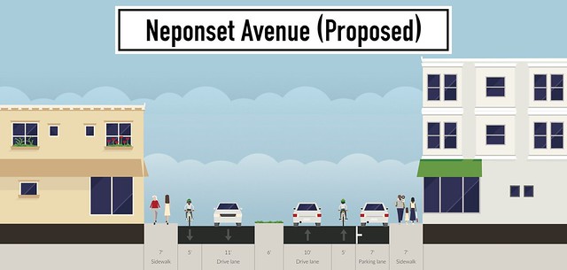
Based on the existing conditions of Minot Street, we propose a cross section as outlined in Figure 10 below.
Figure 10. Cross Section of Minot Street Between Neponset Street and Saranac Street
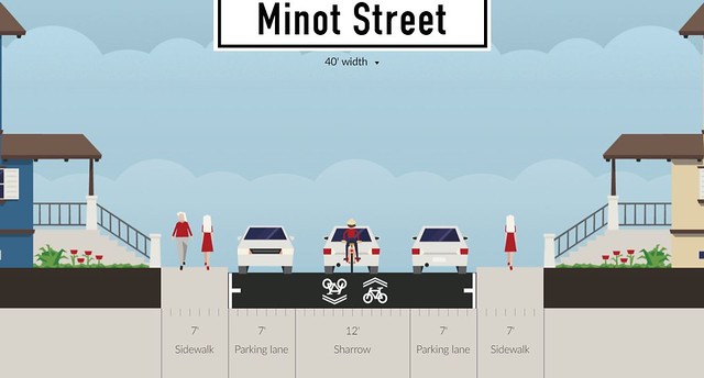
The proposed cross section shows Minot Street as having 7′ parking lanes on either side and a 12′ travel area in the middle for one-way vehicular traffic and two-way bicycle traffic. While 12′ is a narrow space for cars to pass bicyclists, it is the largest space available for travel without moving curbs, which can be expensive, or removing a lane of parking, which we did not deem as necessary. Based on satellite imagery over multiple years, nearly every house on Minot Street has a private driveway for parking. Due to this fact, street parking is light on Minot Street. There are very few spots where cars are parked on both sides of the road at the exact same location. This means that in most locations, vehicles have ample room to pass bicycles. In locations where cars are parked on both sides at the same time, vehicles can very carefully pass a cyclist, or they can wait on the side in the parking zone and pass through after the cyclist is gone.
The laning feature of advisory bike lanes was replaced by the idea of using large two-directional sharrows on the pavement. These sharrows claim the street as a space intended for cyclists and remind car traffic to drive slower and to be aware that bikes can travel in both directions, even though cars cannot.
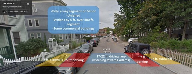
Saranac Street forks off to the north from Minot Street and is one-way westbound. The Minot Street continues as a two-way street with no marked centerline to Adams Street. For this section of Minot Street, the width of the street begins 30-ft curb-to-curb and widens to become 35-ft at the intersection with Adams Street. There is room for one lane in either direction with parking on both sides of the street. Figure 11 shows the existing typical cross section of Minot Street from Saranac Street to Adams Street.
Figure 11. Existing Cross Section: Saranac Street to Adams Street
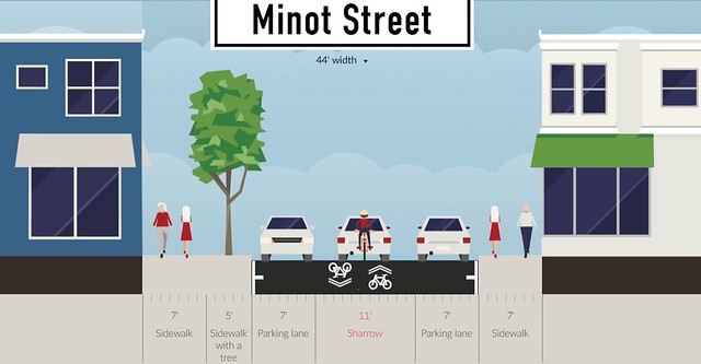
We propose continuing the sharrows along Minot as it forks where Saranac Street begins. This is the widest segment of this street, as it was originally two way and allowed for plenty of traffic to the businesses on either side of the street. However, the proposed plan for this segment is much more accommodating for bicycles; making the street one way away from the main road, Adams Street, means that bikes only have to worry about cars entering the bike boulevard from one direction. It also eliminates a driving lane, creating space that can be used for trees, planters, or street furniture that has the potential to make the street more interesting to look at and to bike along. After the intersection of Minot Street and Adams Street (cross-section shown below), the bike boulevard goes back to its original width and the sharrows continue in either direction to both Clover Street and Frederika Street. Figure 12 shows the proposed cross section of Minot Street between Saranac Street and Adams Street.
Figure 12. Proposed Cross Section of Minot Street Between Saranac Street and Adams Street
From Adams Street to Carruth Street, Minot Street becomes once again a one-way eastbound street with a curb-to-curb width of 26 feet. The proposed bike boulevard will turn south onto Frederika Street, which is between Adams Street and Carruth Street.
Clover Street and Fredericka Street
Clover Street and Fredericka Street are proposed to act as either end of the bike boulevard, providing connections from Minot Street to points south of Gallivan Boulevard. Currently, Clover Street is a one-way southbound residential street with a curb-to-curb width of 20 feet. Frederika Street is a two-way residential street, with a curb-to-curb width of 26 feet. There is parking on one side of Clover Street and on both sides of Fredericka Street. There are no marked center lines on either street, and both streets run from Minot Street to Gallivan Boulevard. We propose adding sharrows and signage to these streets to make the bike boulevard clear to both cyclists and drivers, and adding one speed hump to Fredericka Street to assist in slowing traffic. However, we do not propose changing the directions of either streets, as both streets are very short.
Existing Condition of Intersections and Proposed Solutions
Gallivan Boulevard & Clover Street
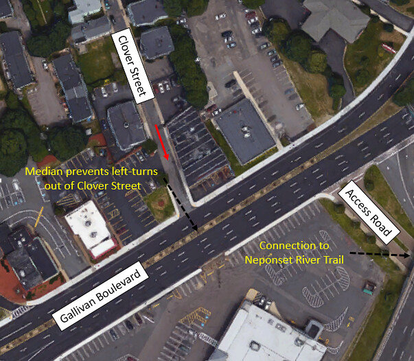
Currently, Clover Street meets Gallivan Boulevard at a stop-controlled intersection, as shown in Figure 13. There are no crosswalks. The intersection is right-out only, as a median currently divides eastbound traffic on Gallivan Boulevard from Clover Street. All exiting traffic on Clover Street must turn right onto Gallivan Boulevard.
Figure 13: Current Intersection of Clover Street and Gallivan Boulevard
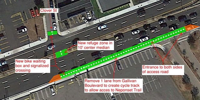
The crossing of Clover Street and Gallivan Boulevard will provide the link between Minot Street and the existing Neponset River Trail. We recommend providing a designated crossing at the end of Clover Street with a refuge zone in the center of Gallivan Boulevard within the existing 10’ median. Finally, we recommend removing one 10′ travel lane from eastbound Gallivan Boulevard to allow room for a two-way cycle track. The lane we recommended removing is one of four eastbound travel lanes on Gallivan Boulevard, and traffic should still be able to flow without this segment of the lane. The park access road is low traffic and will provide a link under the highway to the Neponset River Trail. Figure 14 below shows our proposed design for the intersection.
Figure 14. Intersection of Clover Street and Gallivan Boulevard
Minot Street & Neponset Avenue
Currently, the intersection of Neponset Avenue and Minot Street is a stop-controlled intersection. There is one crosswalk crossing Neponset Avenue on the north side and one crosswalk crossing Minot Street. Minot Street is one-way in the inbound (eastbound) direction approaching the intersection. Figure 15 shows the existing layout of the intersection.
Figure 15. Current Intersection of Neponset Avenue and Minot Street
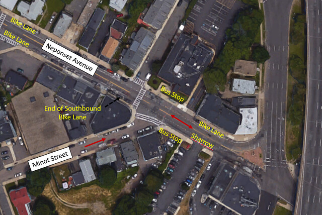
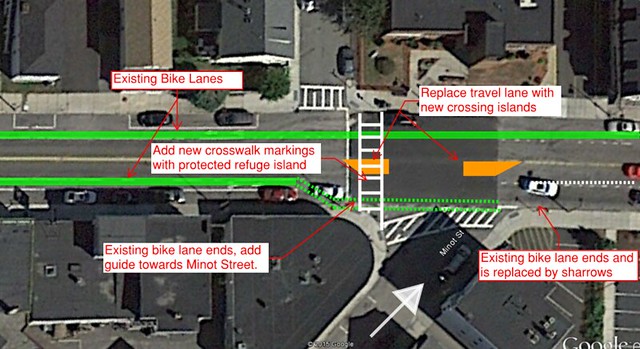
Figure 16 below shows the proposed changes to Neponset Avenue at the Minot Street intersection. We propose the removal of the middle vehicle lane at the intersection to provide space for two medians and a protecting refuge space for bicycles. This will allow bicycles to only cross one stream of traffic at a time when turning to the north onto the existing bicycle lane on Neponset Avenue. The south bicycle lane on Neponset Avenue currently terminates at Minot Street and turns into a sharrow.
Figure 16: Minot Street and Neponset Avenue
Figures 17 and 18 show the existing and proposed cross sections of Neponset Avenue at the location of the crossing island. As shown in the cross sections, the second travel lane has been shortened to allow room for the crossing island.
Figure 17: Existing Neponset Avenue Cross Section at Minot Street
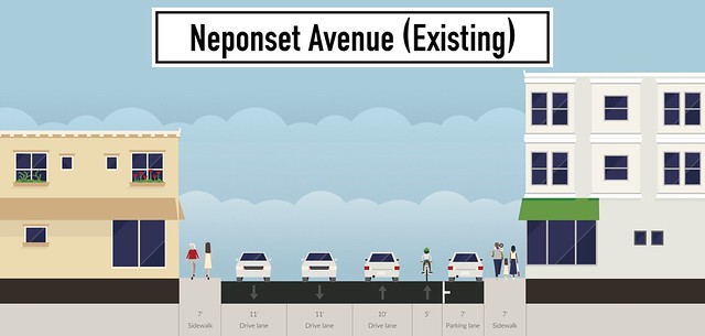
Figure 18: Proposed Neponset Avenue Cross Section at Minot Street
Minot Street & Saranac Street
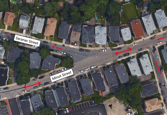
The intersection of Minot Street and Saranac Street is located in a dense residential district. Currently, Saranac Street branches off of Minot Street at an approximately 30-degree angle. Saranac Street is one-way outbound from the intersection. Due to the geometry of the intersection, vehicles do not need to slow down very much in order to turn onto Saranac Street when traveling westbound on Minot Street. Figure 19 shows the existing layout of the intersection.
Figure 19. Current Intersection of Minot Street and Saranac Street
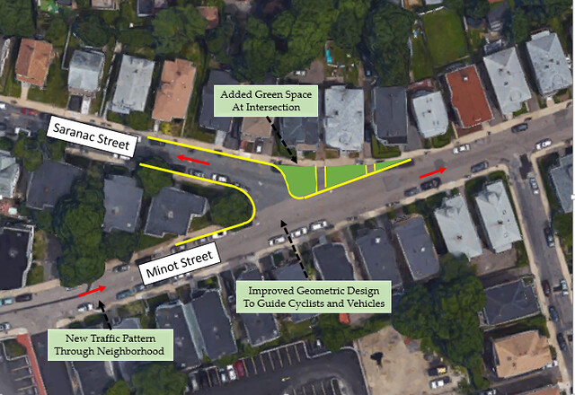
With the changing of Minot Street to one way in the east direction between Adams Street and Branton Street, the westbound traffic flared entrance to Saranac Street is no longer required. Figure 20 below shows the proposed redesign of the Saranac Street intersection where the flared entrance is replaced with green space, providing a more attractive space and inhibiting cars from going the wrong direction to turn onto Saranac Street. This green space could host large planter boxes to make sure cars do not cut across the area anyway and prevent illegal parking, as well as benches or other street furniture for residents to enjoy.
Figure 20. Intersection with Saranac Street
Minot Street & Adams Street
The intersection of Minot Street and Adams Street in Adams Village does not require any redesigning to allow safe bicycle passage. With the changes to the direction of Minot Street at the Adams Street intersection it is no longer possible for cars to turn from Minot Street to Adams Street, allowing bicycles to take over the entire lane and claim the intersection. Bicycles will then be able to use the existing traffic infrastructure for the crossing of Adams Street. However, vehicular traffic flow in Adams Village has been altered due to the change in direction of Minot Street. As shown in Figure 21, it is still easy to travel through the village and access the parking lot off of Minot Street.
Figure 21. Proposed Traffic Flow Through Adams Village
Adams Street & Gallivan Boulevard
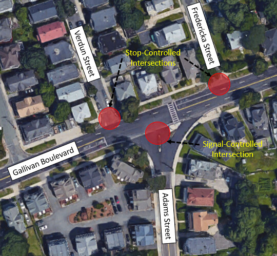
Adams Street and Gallivan Boulevard intersect twice within Adams Village. The first intersection is where Adams Street becomes Granite Avenue south of Gallivan Boulevard. The second intersection is to the west, where Adams Street (South) creates a T-intersection with Gallivan Boulevard. This is the one focused on in this study.
Currently, the intersection of Adams Street and Gallivan Boulevard is a signalled-controlled intersection. There is currently one crosswalk crossing Gallivan Boulevard on the east side and one crosswalk crossing Adams Street. Because the intersection is a T-shape, motorists are forced to turn when they reach Gallivan Boulevard. Figure 22 shows the existing layout of the intersection.
Figure 22: Current Intersection of Adams Street and Gallivan Boulevard
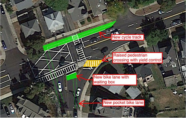
To facilitate bicycles crossing Gallivan Boulevard, we propose adding a cycle track along the green space on the northern side of Gallivan Boulevard and adding a bicycle waiting box on Adams Street on the southern side of the intersection with marked advised paths between them. This will allow bicycles to have their own space while they wait for the signal and then to be guided to the cycletrack or bike lane on the opposite side of the intersection. Figure 23 shows the layout of the proposed intersection changes.
Figure 23. Intersection of Frederika Street, Gallivan Boulevard, and Adams Street
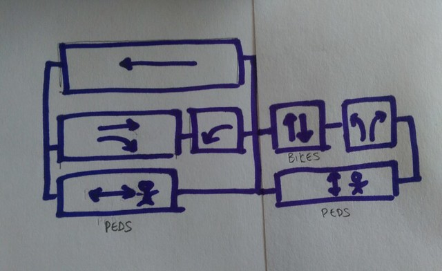
In order to accomodate bicycle traffic through the intersection of Adams Street and Gallivan Boulevard, the timing of the signal will need to be changed to add a bicycle phase. Figure 24 below is a rough sketch of the traffic phasing at the intersection of Adams Street and Gallivan Boulevard with the new bicycle facilities. The first phase is for the east-west traffic. Westbound through traffic is allowed to run the whole phase, while eastbound through and right traffic runs for most of the phase, stopping to allow westbound left turns. Pedestrians are also allowed to cross concurrently with eastbound traffic. The second phase is for north-south traffic. The cyclists crossing Gallivan Boulevard will have their own protected phase and not have to cross with vehicular traffic. Afterwards, vehicles will be allowed to make their left turns onto Gallivan Boulevard while pedestrians are still allowed to cross concurrently, as the left turns do not affect the pedestrians. Northbound right turns will have a yield-controlled turn, which saves motorists and pedestrians from waiting at a signal.
Figure 24. Proposed Signal Phasing at Adams Street and Gallivan Boulevard
Conclusion
Adams Village is an area that is currently underserved by bicycle infrastructure. This design proposes adding a new, low-cost bike boulevard that would utilize existing low-traffic streets. The bike boulevard would follow Minot Street to parallel Gallivan Boulevard, which is the main east-west road though Adams Village. The bike boulevard would limit vehicular traffic to one-way, but it would allow contraflow bike traffic throughout. The one-way vehicular traffic limits the amount of cars on the road, but the contraflow bike traffic shows that the street is dedicated to bicycles. This boulevard would allow access to local residential and commercial areas with a low impact on the residents of the neighborhood. In addition, this bike boulevard would provide connections to the greater Boston bicycling network via the Neponset River Trail and existing bike lanes on Neponset Avenue.