Bike Lanes – Group 3
Team Members: Peter Calves, Katie Laughinghouse, Kim Perrone, Maggie Osbahr, Maddy Wax
Primary Authors: Peter Calves and Kim Perrone
Section 1 – Overview
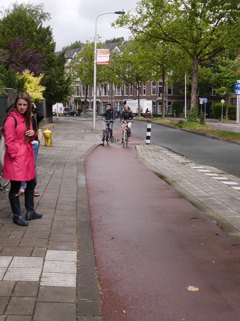
A bike lane is a part of the road designated only for bicycles and not to be shared with cars or pedestrians. It is usually located between the travel lane and the parking lane (if there is one) and is marked with a solid white line. The bike lane may be painted a different color such as green or red. Here is one example of a bike lane.
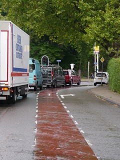
Fig 1. Pocket Bike Lane on Mekelweg at Zuidplantsoen
This is a map of delft. The red lines are the bike lanes that we studied.
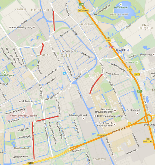
Fig 2: Map of studied bike lanes
Section 2 – Design when Bike Lanes are and aren’t next to parking lanes
When bike lanes are not next to parking lanes, they can be anywhere between 4 and 6 feet wide. When they are next to parking lanes, the total width of the bike lane plus the parking lane (also known as the reach) should be between 14 and 15 feet. This is to reduce the risk of dooring. In this scenario, the design might also include a buffer zone to encourage drivers to park towards the curb. This area could be from 1.5 to 3 feet wide or more if it were to be made into a tree strip.
| Location | Description | Bike Lane width | Buffer zone | Speed limit |
| Buitenhofdreef | 1+1 lanes, transit rail in the median, parking on one side | 6.3’ | none | 50 km/h |
| Martinus Nijhofflaan | 1+1 lanes, transit rail in the median, no parking | 6.0’ | none | 50 km/h |
| Hof van Delftlaan | two way street, parking both sides, shared street? | – | – | 30 km/h |
| Reineveldbrug | 2+2 lanes, rail lines share the middle two lanes, no parking | 4.0’ | none | 50 km/h |
| Julianalaan | 1+1 lanes with median, no parking, buffer zone marked with dotted line | 6.6’ | 2.5’ | 50 km/h |
Section 3: Design for Bike Lanes at Intersections
Pocket Bike Lanes and Bike Turning Lanes
Pocket bike lanes are bike lanes that transition from the furthest lane toward the curb to the second furthest, to allow for a right turn lane. A bike turning lane is, as the name suggests, a turning lane for bikes. A pocket bike lane is marked by a bike lane extending straight off of the curb as a turning lane extends to its right. A pocket bike lane is used whenever there is a need for a right turn lane, but bike traffic continues to the right. Examples of this in the areas we visited included northbound on Buitenhofdreef at Martinus Nijhofflaan and northeastbound on Julianalaan at Poortlanplein. A bike turning lane is indicated by a bike silhouette with a turning arrow above it in an intersection approach. This is used either when there are multiple lanes for turning bikes to cross at once (usually left turns) or when a bike route continues on-road, while a pocket bike lane also extends straight through. The right turn approach can be seen best from our tour northbound on Buitenhofdreef at Martinus Nijhofflaan. The left turn approach can be best seen on Vrijenbanselaan at the north end of Reineveldbrug.
| Location | Description of Area | Bike Lane Width | Vehicle Turn Lane? |
| Buitenhofdreef | 1+1 with median transit reservation | 5-6’ | Left turn lanes at all Intersections,Right turn lane at Vrijheidslaan
Right turn pocket with delta island at Martinus Nijhoflaan |
| Martinus Nijhofflaan | 1+1 with median transit reservation | 4-5’ | At Art van der Leeuwlaan: EB left turn lane, WB left turn lane and right turn pocket with delta islandAt Buitenhofdreef: Left turn lane, Right turn lane with delta island |
| Hof van Delftlaan | unlaned street, parking on both sides | 5’ | No |
| Reineveldbrug | 2+2 with street running transit in inner 2 lanes | 5-6’ | At South End: left turn lane and right turn pocket with delta islandAt North End: right turn pocket with delta island |
| Julianalaan | 1+1 with bus stop platforms | 6’ | At Poortlandplein:NEB right turn pocket with delta islandAt Simonsstraat: SB Left turn lanes |
The bike lanes we saw differ from bike lanes in the US as to being a part of an integrated streetscape. Bike lanes in the Netherlands are viewed as equally important as vehicle lanes, sidewalks or transit reservations. This is indicated by the change in color of the road surface. In the US bike lanes are often viewed as a retrofit, an addition to the road that is not as important as the vehicle lanes, sidewalks, and transit reservations. That can be seen in the simple white markings that are US standard for bike lanes. These simple marking and the different mindset lead to the experience being wildly different in the two countries, despite the physical similarities of the treatments themselves.
Section 4: Operations of Observed Areas
Buitenhofdreef consists of one lane of traffic in each direction with a grassy median transit reservation. This route has one way bike lanes running along each side with tram route 1 running in tracks in the central reservation. At the time we observed it, the traffic was very light, as it was midday in a mostly residential area. Due to this low traffic, often cyclists will overtake outside of the bike lane. This is not what is intended, but it is not unsafe due to the low speed of traffic.
Martinus Nijhoflaan consists of one lane of traffic in each direction with a grassy median transit reservation. This route has one way bike lanes running along each side, with tram route 1 running in tracks in the central reservation. At the time we observed it, the westbound side of the street had construction abutting it near the De Hoven shopping centre. This narrowed the bike lane and pushed it out into area formerly part of the travel lane. This was done as well as it could be, but still makes it very uncomfortable to ride through this area, particularly as traffic is accelerating away from the roundabout at Papsouwselaan at that point. They should have better coordinated with the construction to provide a more comfortable riding experience.
The Hof van Delftlaan consists of two unlaned residential streets divided by a stretch consisting of one lane in each direction separated by parking in a small commercial area. The residential part of the street has one way bike lanes on each side, while the commercial area has shared street pavement materials.
The Reineveldbrug and its approach roads Wateringsevest and Vrijenbanselaan, north of Delft center, consist of two lanes of traffic in each direction, with street running transit in the inner two lanes. This route has one way bike lanes running along each side, and tram lines 1 and 19 running in tracks in the inner two lanes. At the time we observed, the drawbridge was closed and traffic was flowing freely. The main thing I noticed was that the middle two lanes could be used by vehicle traffic when no tram was present. This allowed the traffic in the lanes adjacent to the bike lanes to be lighter than it would be if there was only a single lane in each direction. This seems to be an intentional choice, as it allows bike travellers to have lower stress than there was a single traffic lane and a centre transit reservation.
The stretch of Julianalaan near the TU-Delft campus heading toward the city center consists of one lane of traffic in each direction with a grassy median in the centre. This route has one way bike lanes along both sides, with bus routes 60 and 64 running through the area. At the time we observed it, traffic was fairly light, which enabled the vehicle traffic to flow faster than usual. This made the cyclist traffic slightly more narrow than usual, which was a bit uncomfortable. This is most likely as intended for midday traffic, which would be lighter than the design capacity for all modes and allow for higher running speeds. The areas where bus stops are located, the bike lanes come up to sidewalk level, allowing for a level bus boarding area.