Team: Kim, Ryan, Katie L, (Joel)
Topic: Koningstunnel in Relation to Den Haag Centraal
The City of Den Haag utilizes a ring road system to provide a high capacity route encircling the urban core. To compliment this, the potential for through traffic within the enclosed area is reduced or removed. Cars may enter from the ring road to a particular area within the urban core, but are unlikely to be able to be able to cross form one side of the center to the other. Although this concentration of traffic is designed to improve the congestive and environmental impacts of allowing traffic to freely enter the downtown area, we must then address the disruptive impacts of the ring road itself and ensure connectivity across the road. This wider route is now the most efficient way for cars to travel around the urban core, but this should not be at a cost to pedestrian and bicycle flow.
Koningskade is part of the ring road in the Hague which originally created a barrier between Centrum and Centraal Station – a considerable amount of foot and bike traffic was therefore delayed by the ring road. A solution to this problem was implemented with the construction of the Koningstunnel: a section of the ring road was placed in a tunnel, leaving an open space above for the movement of people from the residential areas and Centraal Station to the east into The Hague city center, without disrupting the flow of cars. The tunnel allowed pedestrians to bypass a significant crossing barrier while also providing an additional park space over the northern section of the tunnel.
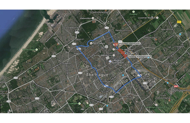
Pictured Above: In blue, the S100 ring road around the urban core. In red, segments of the road under our design consideration, detailed below.
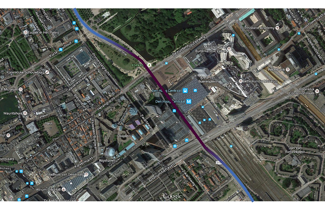
The figure above depicts the ring road as it crosses between Den Haag Centrum and Centraal Station. Blue indicates where the road is at-grade, purple indicates where the road is below grade within a tunnel. Note the density of buildings appearing to either side of the ring road – the original ring road was a barrier to the considerable pedestrian and bike demand associated with these buildings.
Potential Applications
It is our opinion that this concept can be applied at other points on the ring road to further improve at-grade access to the city. While scoping potential intersections for use of a tunnel we considered the volumes and corresponding physical barrier of the major intersections or segments along the ring. Based on our observations, the northern and western sides of the ring had comparatively smaller sections and lower volumes than the eastern side and did not create a considerable barrier. The southern side of the ring runs along a canal for much of its length; if this segment were to be placed in a tunnel the barrier created by the canal would remain. The eastern segment of the ring road, to the north of the existing Koningstunnel, separates residential areas from the urban center and has high vehicle volumes. Volumes are particularly high at the intersection of S1oo and S1o1, which connects the ring road to the A12 highway. For this reason, the intersection of S100 and S101 was selected to be redesigned with a tunnel element to improve flows through and over the ring road.
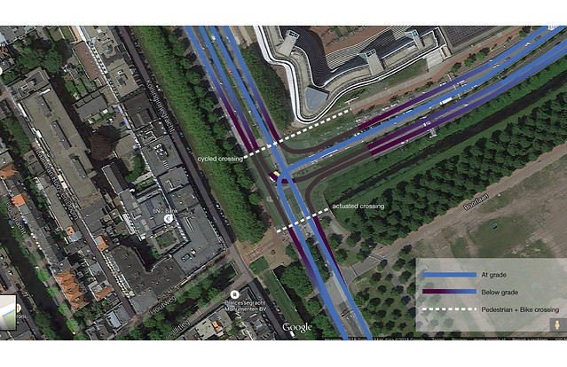
The existing intersection consists of 14 entering and exiting lanes from three directions; north, south, and east. This location must be treated differently than the Koningstunnel solution because it is a three way rather than a four way intersection. Likewise, the traffic from the A12 highway to the east makes it necessary that a connection be made between the two roads rather than a simple overpass. If only the ring road were placed underground in this section, the crossing road (S101) would end abruptly and it would be difficult to make a connection to another street. Alternately, an underground high speed connection would require expansive and costly underground ramps. An underground signalized intersection was also considered, but while this would improve pedestrian and bike connectivity, it would not improve flow along the ring road. Consequently, we propose placing as many non-conflicting lane directions below ground as possible, avoiding conflicts by allowing through traffic to continue uninterrupted at ground level. Underground lanes would ramp back to grade downstream of the intersection and merge with any at-grade lanes. This configuration, shown in the figure below, would leave only one conflict within the entire intersection – requiring simple two-phase signaling. The pedestrian crossing on the ring road will be moved north of the intersection and will receive cycled green lights. An additional actuated crossing will be located on the southern side of the intersection and will only be triggered by detection of a bicycle or push button.
There are existing tram lines on the opposite side of the canal which are not currently impacted by the intersection or ring road and will not be affected by the proposed design.
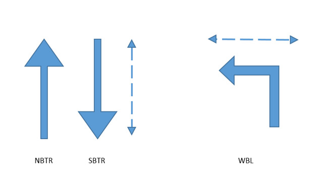
Although the one remaining conflict requires a traffic signal, the simple two phase cycle required will not jeopardize efficiency. The first signal phase gives northbound though traffic on the ring road a green, the second phase gives a green to westbound left turns and a red to northbound through lanes. During the first phase pedestrians are given a conflict free north-south crossing on the east side of the intersection. During the second phase, pedestrians are given a conflict free crossing on the north side of the intersection.
This solution accomplishes the goal of improving traffic flow for all modes of transportation and improving connectivity across the ring road. Under the proposed design, all travel directions but S100 northbound and S101 westbound left turns will continue through the intersection uninterrupted. These directions, however, will now also have much less delay as each movement can be given 46% of the green time. Additionally, pedestrians and cyclists now have conflict free crossing and are only required to cross fewer than half of the existing lanes.
It should be noted that although the proposed configuration of the S100 and S101 intersection would increase the capacity of the intersection, the S100 ring road would have little net gain in capacity without addressing the capacity of nearby intersections. To the south, S100 runs relatively uninterrupted for roughly one mile before a major intersection with Weteringkade. To the north, S100 runs only 0.5 miles before turning left at a major four-way intersection. The capacity of this corner intersection is a major concern regarding the capacity of the ring road as a whole. Though it is not studied in this report, any improvements to the S100-S101 intersection would require corresponding capacity improvements to the S100 turn to the north.