Advisory Bike Lanes
Christine Lai, Chase McLaughin, David Roglieri, Tiffany Ma, William Huang
Overview:
For streets that are have moderately low volume and are too narrow to accommodate bike lanes, advisory bike lanes can be used to delineate a space for cyclists. They are typically placed on streets with a daily volume of about 1000 to 4000 vehicles. Advisory bike lanes are lanes marked by a dashed line, where cyclists are suggested or “advised” to bike in. Meanwhile, there is a central undesignated driving strip between the advisory bike lanes. Cars in either direction usually drive in this central strip. But when cars approach from opposite directions, they are allowed to shift (partway, of course) into the advisory bike lanes to pass by the oncoming traffic. Cars may also shift like that when encountering bikes, though the central driving strip is usually wide enough that they don’t have to shift to pass a single bike. Instead of having little to no designated area for bikes on the street, advisory bike lanes provide cyclists with a space that’s clearly marked as “theirs.” Motorists will then be more aware that cyclists are expected on the road, and will be more respectful of giving them the space they need when passing. Meanwhile, cyclists can bike without worrying that they are in the vehicle’s path.
Design:
We visited the following streets in Delft with advisory bike lanes and took down the below dimensions. Pictures of the streets are seen below the data tables.
Table 1: Hugo de Grootstraat
| Location | Street | Parallel Parking | Central strip | Speed Limit | Central strip | Bike Lane |
| C1 | Hugo de Grootstraat | No | 1 | 50 KM/H | 12′-7″ | (2) 5′-0″ |
*Bikes lanes on either side of the travel lane
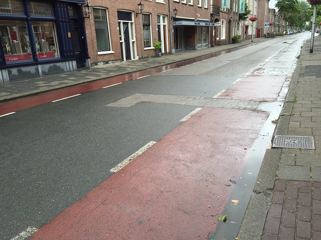
Figure 1: Hugo de Grootstraat street view
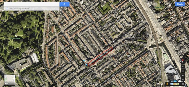
Figure 2: Hugo de Grootstraat aerial view
Table 2: Adriaan Pauwstraat
| Location | Street | Parallel Parking | Central strip | Speed Limit | Parking | Central strip | Bike Lane |
| C2 | Adriaan Pauwstraat | Yes | 1 | 50 KM/H | 6′-0″ | 10′-2″ | (2) 5′-3″ |
*Bikes lanes on either side of the central strip
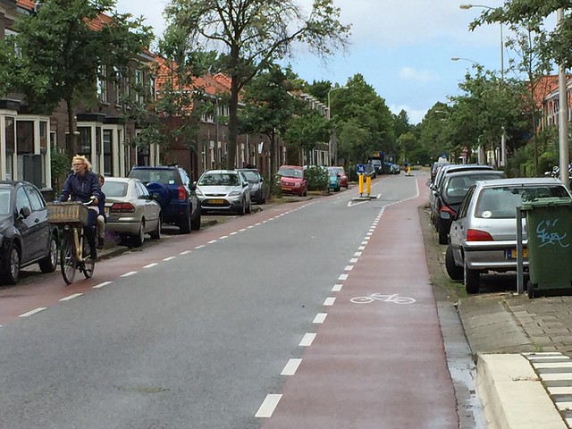
Figure 3: Adriaan Pauwstraat street view
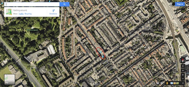
Figure 4: Adriaan Pauwstraat aerial view
The following are typical cross sections for advisory bike lanes that we studied:
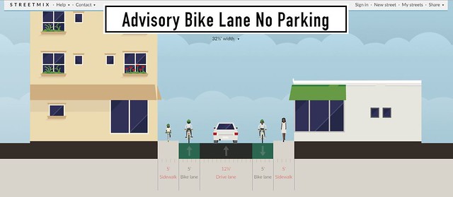
Figure 5: Advisory Bike Lane w/ No Parking
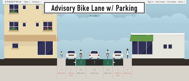
Figure 6: Advisory Bike Lane w/ Parking
The advisory bike lanes we saw were narrower when compared to conventional bike lanes. The advisory bike lane widths seen on both streets with and without on-street parking were five feet wide, while bike lanes that we saw on other streets averaged six feet wide. Because the street is not wide enough to accommodate two full-sized travel lanes and graciously-spaced bike lanes, the advisory bike lane widths are at a minimum so functionality is maximized. Not too much space would want to be allocated to either vehicles or bikes, just enough to adequately serve their purposes.
Streets in Boston that could use advisory bike lanes include: Saint Botolph Street, Gainsborough Street, Calumet Street, and Agassiz Road. Saint Botolph Street, Gainsborough Street, and Calumet Street all have parking on both sides while Agassiz Road does not have parking at all. Advisory bike lanes can be implemented on one- and two-lane roads as shown below. Hopefully, they will promote bike ridership with low stress and connectivity.
Implementation on two-way streets:
St. Botolph Street
St. Botolph Street has a medium traffic volume and is located in Back Bay of Boston. It is a back street to Huntington Avenue and the Prudential Center as shown below:
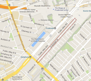
Figure 7: St. Botolph Street aerial view
Our proposed design for St. Botolph Street is shown below. There will be 7′ parking on both sides of the street while also having 5′ advisory bike lanes on both sides of the street. Cars will have ample room to pass bicyclists by staying in the center of the road and, if needed, enter the advisory bike lane on the other side of the street. This design will help provide a safer and more enjoyable area for bicyclists to cycle.
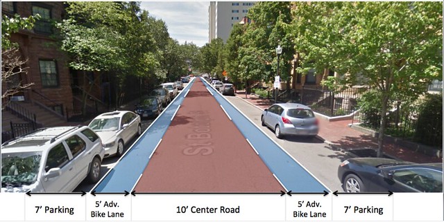
Figure 8: St. Botolph Street street view
Calumet Street
Calumet Street is a residential street home to students and families. There are students cycling down the hill to class, and a few young children riding bikes around with parents. The students are usually riding very fast, in every which direction. Calumet is a two-way street with parking on both sides, though with both sides lined with cars two passing cars have a very narrow space to pass, if any at all.
The width of the road is around 33′ curb-to-curb street. We propose keeping the current width and adding a 4.5′ one-way advisory bike lane and 7′ parking lanes on both sides, with a travel lane of 10′ in the middle. This will provide enough space for cars to drive down the travel lane without encroaching on cyclists.
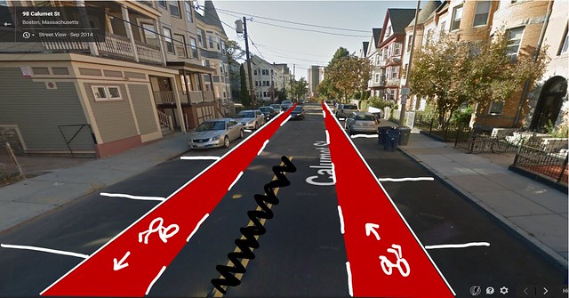
Figure 9: Calumet Street street view
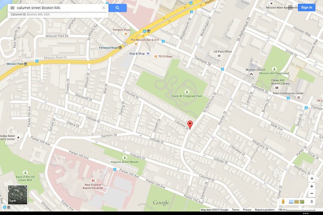
Figure 10: Calumet Street aerial view
Implementation on one-way streets:
Putting advisory lanes on one-way streets enables those streets to be two-way for bikes. One of the advisory lanes is a contraflow advisory lane.
Gainsborough Street
Gainsborough Street is a residential street with an approximately 32-feet width curb-to-curb. For this, we propose 7-ft parking and 4.5-ft advisory bike lanes on both sides, leaving a 9-ft travel strip. Since this is a residential street, we can encourage local traffic by creating a slightly smaller travel lane to keep larger vehicles away or from driving too quickly. That’s because the smaller lane makes the road to appear narrower, in turn hopefully slowing down the drivers.
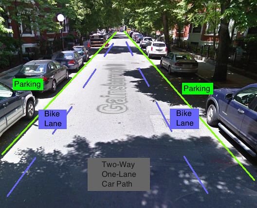
Figure 11: Gainsborough Street street view
Figure 12: Gainsborough Street aerial view
Agassiz Road
Agassiz Road connects one side of the Back Bay Fens to the other for traffic heading east bound. As seen in the figure below, cyclists often use it to bike with traffic and contraflow to traffic. By implementing advisory bike lanes, we can provide cyclists a space to ride in the street without as much stress than if there were no bike lanes. The current curb-to-curb width is approximately 20 feet. We are proposing 5-ft advisory bike lanes on each side with a 10-ft travel strip.
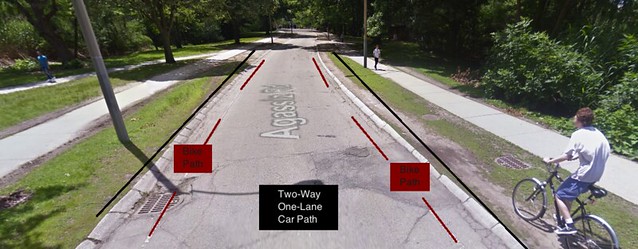
Figure 13: Agassiz Road street view
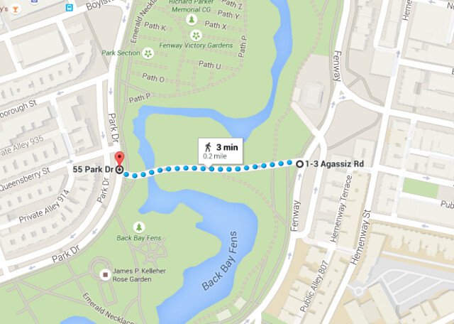
Figure 14: Agassiz Road aerial view
Operations:
The bike and travel lanes that we watched were all utilized as intended. Bikes tend to stay within the advisory bike lanes when the lanes are adjacent to the curb, but did occasionally cycle close to the lane line when adjacent to the door zone of parked cars. When a car approaches a cyclist, the cyclist would typically move closer to the curb or parked car to avoid any possible collisions. Cars would drive down the middle of the road, slightly to the side they are traveling on but not touching the advisory bike lane, unless approached by oncoming traffic. At this point the two cars would each move into their respective advisory bike lanes, after checking for cyclists nearby, in order to pass each other successfully. We did notice that because these streets did not have a large amount of vehicular traffic, many of the cars would be going faster than the speed limit until they approached an obstacle.
As you can see in the video, when a car wishes to pass a cyclist, they will move towards the center of the road to pass and avoid hitting the cyclist. If there were any oncoming traffic as the car moved, it would move over towards its respective side to avoid a head-on collision with the car trying to pass a cyclist. If there is another cyclist on the opposite side where the car needs to move into, the car would yield, letting the cyclist pass first before moving into the advisory bike lane.
Figure 15: Video