Advisory Bike Lanes
Group 3: Peter Calves, Katie Laughinghouse, Maggie Osbahr, Kim Perrone, Maddy Wax
Written by: Maggie Osbahr and Maddy Wax
Overview
Advisory bike lanes are areas designated for bicycle traffic on a street, delineated with dashed lines painted on the road. They are commonly found on slow speed, narrow local roads with moderate traffic volume. While there are no physical barriers preventing vehicles from crossing into advisory bike lanes, there are red markings on the pavement giving bikes priority within the space. Vehicles are expected to stay in the middle of the road in their zone between advisory bike lanes until they pass another vehicle traveling in the opposite direction. When this occurs, the two vehicles move to the sides of the street and enter the advisory bike lanes for a short distance to make passing possible. Our group saw four examples of advisory bike lanes in one neighborhood of Delft: Hugo de Grootstraat, Adriaan Pauwstraat, and two different sections of Westplantsoen.
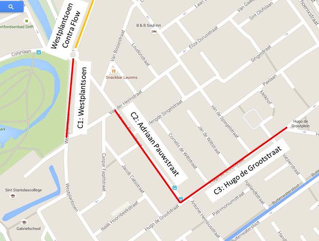
Figure 1: Locations of advisory bike lanes
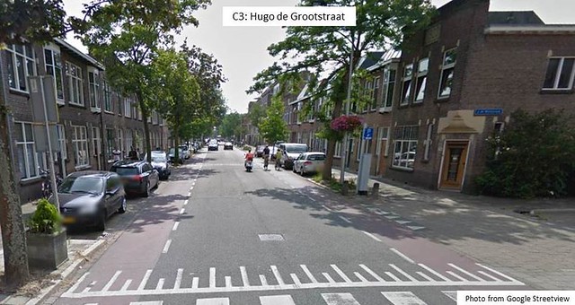
Figure 2: Streetview of Hugo de Grootstraat
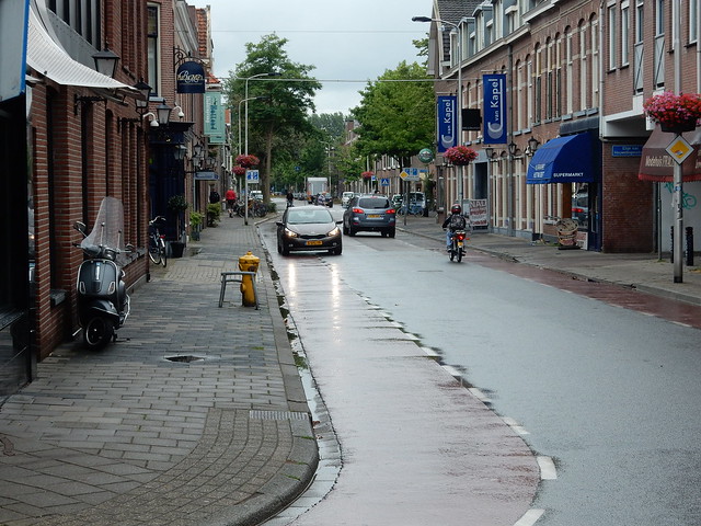
Figure 3: Vehicles passing on Hugo de Grootstraat
In the case of Hugo de Grootstraat, cars could pass each other easily, as seen in Figure 2 and Figure 3, and often did not need to enter the bike lanes. However, when buses were traveled on the street, the larger width of the bus caused one of the vehicles to move into the bike lane to allow for passing. There was no parking on the part of the road in Figures 2 and 3, but there is parking farther down the street. Figure 4 shows a car who temporarily stopped on this road in the advisory bike lane.
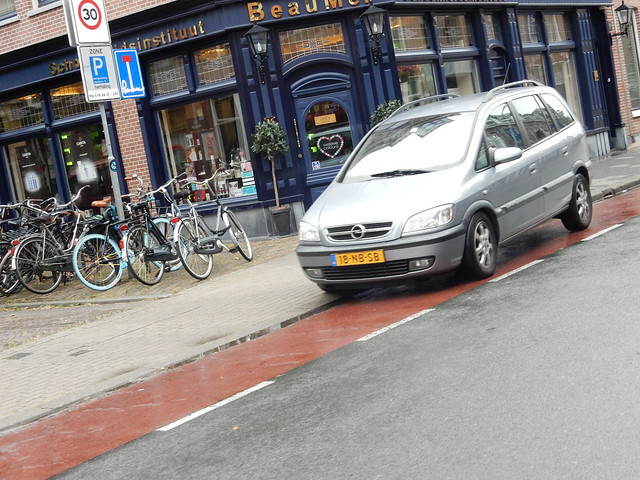
Figure 4: Vehicle stopped in advisory bike lane.
The second advisory bike lane we viewed was on Adriaan Pauwstraat. Similar to Hugo de Grootstraat, Adriaan Pauwstraat had vehicle flow in both directions and a bus route. It also included parking lanes and advisory bike lanes on either side of the road. Additionally, Adriaan Pauwstraat was much more residential, as can be seen in Figure 5, than Hugo de Grootstraat.
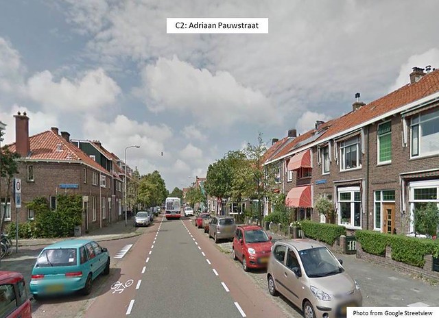
Figure 5: Streetview of Adriaan Pauwstraat
At one point on Adriaan Pauwstraat, there was a crossing section for pedestrian that split vehicular traffic. This forced cars in both directions into the advisory lanes, as the travel zone for cars was only about 6 feet on either side of the crossing island, as seen in Figure 6. The narrow areas on either side of the pedestrian crossing refuge allowed for cars to travel by entering the advisory bike lanes, but causes cars to slow significantly as the undesignated zone of black pavement shrinks greatly. The goal of this split was to force traffic to slow down during periods in which there are few bikes or cars coming in the opposite direction. The decrease in vehicle speed and the placement of the traffic island also makes the street safer for pedestrians, many of whom must walk across the street to get to their parked cars, other streets in the neighborhood, and bus stops that are along this road.
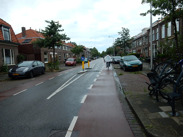
Figure 6: Pedestrian crossing on Adriaan Pauwstraat
Our group briefly rode down Westplantsoen to find similar advisory bike lanes to the other two. There was parking on both sides of this road.
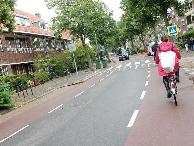
Figure 7: Advisory bike lanes on two-way portion of Westplantsoen
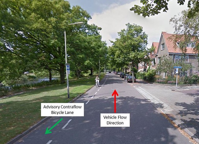
Figure 8: Westplantsloen Contraflow Advisory Lane
The fourth example was a northern section of Westplantsoen, which unlike the other examples is a street that is one-way for cars. For bikes, there was both a with-vehicle-flow advisory bike lane and a contraflow advisory lane for bicycle traffic flowing in the opposite direction of vehicles. That allows bikes to safely ride both directions on the street, preventing them from having to make unnecessary, possibly unsafe detours. Because it is one way for cars, it is unlikely that two cars would need to pass and use the advisory bike lane to do so, meaning the safety of cyclists is not in question. Only rare circumstances, such as parking or a stopped vehicle, would cause a car to enter into the bike lane.
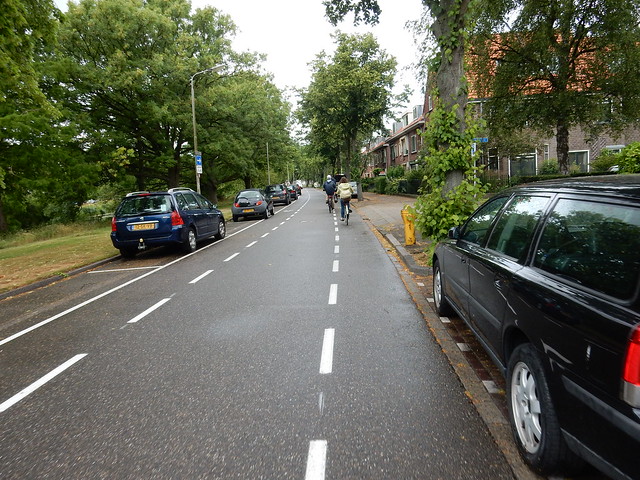
Figure 9: Westplantsloen Contraflow Advisory Lane
Design
Advisory bike lanes are designed on streets with high enough traffic to warrant separation of bicycles and vehicles for safety, but low enough traffic that lanes separating vehicle flow direction are unnecessary. These roads tend to be in residential or light commercial areas. The desired behavior is for vehicle traffic to travel down the middle of the road except when passing. The theory behind these roads is to allow vehicles to borrow road space from bicycle lanes on an as-needed basis. This potential for temporary sharing of space allows roads to have bike lanes installed when they would not fit if they were traditional exclusive bike lanes.
On roads with advisory bike lanes, there are no centerlines marked for vehicular traffic. Space designated for bikes is marked with red pavement—paint or bricks—and a dashed border. The designers place an emphasis on providing enough space for bicyclists and sometimes for parking, and leave the remaining space for vehicle traffic in both directions. Vehicles are expected to share space in the center of the road, entering into bike lanes only when necessary for passing.
The following table includes a breakdown of lane widths that we saw on the facility tour.
| Lane Type | Westplantsoen | Adriaan Pauwstraat | Hugo de Grootstraat | |||
| Count (#) | Dimensions (ft) | Count (#) | Dimensions (ft) | Count (#) | Dimensions (ft) | |
| Travel Lane | 1 | 10 | 1 | 10.5 | 1 | 15 |
| Bike Lane | 2 | 5 | 2 | 4.5 | 2 | 5 |
| Parking Lane | 2 | 7 | 2 | 6.5 | 0 | N/A |
In Boston, one potential implementation is on Parker Street between Tremont Street and Ruggles Street. Parker Street has been chosen first and foremost because our group knows multiple Northeastern students who bicycle here and have been hit by a car or had a close encounter. This street is ideal because most of the vehicle traffic on the road is to access the stores and apartment buildings along this section of Parker, and because it is currently wide enough to have a single lane for vehicle traffic flow and two advisory bike lanes while maintaining the street parking. Additionally, while being a fairly local street, there is still high enough traffic that bicycles should be given designated cycling lanes, but there is not enough space for bike lanes and a 1+1 vehicle traffic street while maintaining parking that is necessary for Northeastern students, local residents, and patrons of the small businesses along the road. Finally, the addition of bike lanes could improve the commute of many students living in Mission Hill and Roxbury neighborhoods. This street serves as a connection between Tremont Street, Ruggles Street, and Huntington Avenue. The flow spikes in peak hours, but the specific area we selected sees less traffic than the additional section between Ruggles Street and Huntington Avenue. This heavier flow section has been excluded from our redesign.
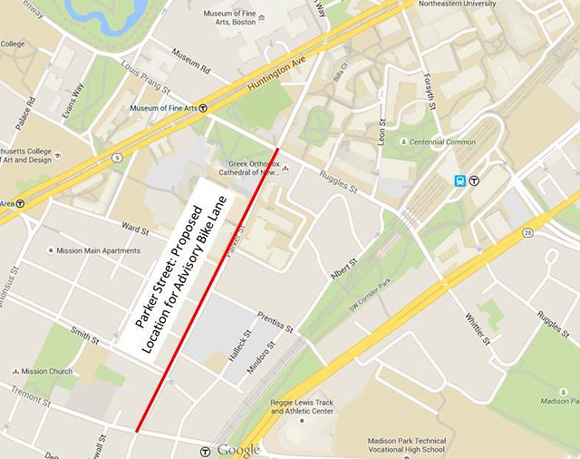
Figure 10: Location of Redesign on Parker Street
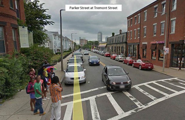
Figure 11: Current Streetview of Parker Street at Tremont Street
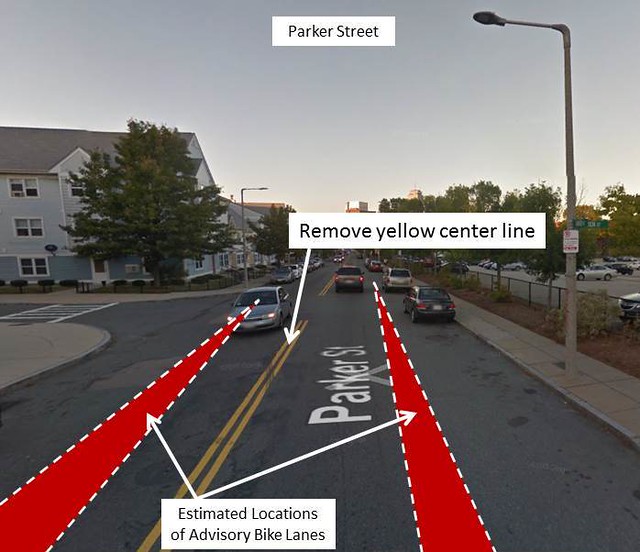
Figure 12: Proposed Redesign of Parker Street
Another potential example for advisory bike lanes is on Oxford Street in Cambridge, MA. This area already has heavy bicycle traffic but lower vehicular traffic. Currently there are two lanes in a 25 mph zone, but no bicycle infrastructure. Oxford Street is used in the neighborhood as a local connector to Massachusetts Avenue, Beacon Street, and Cambridge Street, but does not experience high-speed vehicles due to the residential nature of the road and the many speed humps and traffic lights. This could be fitted with an advisory bike lane to increase the safety of the many bicycle commuters that use the street, and to offer an alternative to Massachusetts Avenue for cyclists.
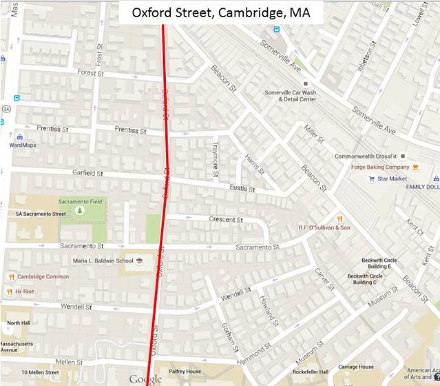
Figure 13: Location of Redesign on Oxford Street.
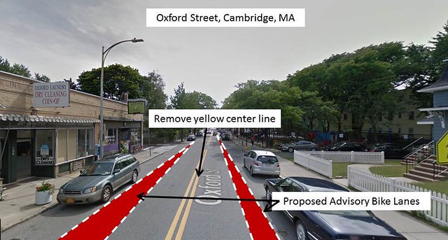
Figure 14: Proposed Redesign for Oxford Street
Operations
At the advisory bike lanes we visited we saw the sharing of vehicular and cycling traffic. There were cases when a car passed in the center of the road with two bicycles on either side. When faced with another car, these vehicles slowed and, though they occasionally entered bike lanes, vehicles were more aware of their surroundings. Cyclists seemed to carry on without opposition.
As a whole, our group had mixed review with respect to advisory bike lanes. Many of us really liked them. The resounding support for this was due to the complete dominance these lanes provide to bikes. On advisory bike lanes, cars are bike dependent so they have to rely on bikes to determine their flow patterns, particularly when approaching other vehicles.
There were also students who felt uncomfortable while on these bike lanes. These sentiments were due to the proximity to passing vehicles. This was intensified most specifically on the contraflow bike lanes when riding on the south side of the road with a dumpster was parked in an adjacent parking space. A car, traveling relatively fast passed at the exact moment students were passing the dumpster. The dumpster was wider than a typical vehicle and took up some of the contraflow lanes, making the passing of the car closer than students were used to. However, this circumstance that caused a few members of our groups to be nervous riding is uncommon and is not typical of these bike lanes.
However, the group is unanimous with our opinion that when faced with the choice of an advisory bike lane or no bike facility, the advisory bike lane option should be strongly considered. That and trees.