Underpasses and Bridges
Christine McGeein, Chase McLaughin, David Roglieri, Tiffany Ma, William Huang
A1. Abstwoudsebrug –
This bridge allows quick access over the canal that would otherwise require a longer detour by 20 minutes. This bridge also opens by pivoting to allow larger boats coming down the canal to still pass by the bridge and continue on their route. This spinning mechanism makes the bridge much more expensive to build and operate, however it was a necessary addition that could only be avoided by raising the bridge much higher above the water. If the bridge is raised too much, it would make the bike and pedestrian lanes sloped for a longer distance to meet the appropriate grade in both directions and the space constraints wouldn’t allow this.
As seen in Figure 1, Abstwoudsebrug allows significant distance to be cut off on travel from TU Delft to the area west of the bridge which is blocked by the Delftse Schie. The alternate route is highlighted in red and the extra distance that would be needed to travel is 1.7 kilometers. Instead of traveling that extra distance, bikes and pedestrians can now bike/walk across the bridge which is normally a 20 minute walk. This bridge is for bikes and pedestrians only and can not be accessed by car traffic. As seen in the Figure 2, this bridge is restricted to pedestrian, bike, and moped travel only adding significant value for these types of transportation over car travel.
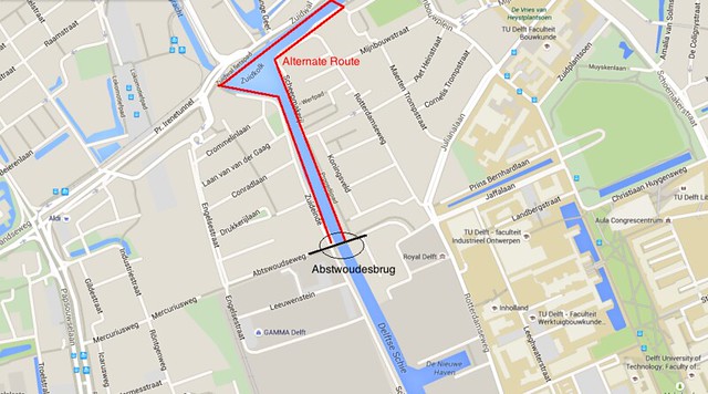
Figure 1: Locus map of Abstwoudsebrug and the alternate route
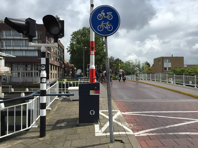
Figure 2: Bike and pedestrian use only
A2. Abstwoudestunnel –
Abstwoudsetunnel used to connect a bike path to Abstwoudsebrug, which provides a shortcut over the canal for pedestrian and bike traffic. This tunnel is no longer in operation because it has become an undesirable path for bikers due to accumulated trash, graffiti, and water. At the moment there is a temporary bike path around the tunnel. This path being underground allowed easy and safe pedestrian crossing above the bike path and let the path go under roads without bikers having to cross them or additional signals being added. Making this path a tunnel greatly increased especially with the high water tables in Delft requiring additional wall support and water table control.
Abstwoudestunnel, as shown in Figure 3, allows access between Mercuriusweg and Abstwoudsweg which was blocked by a railroad. This tunnel allows both pedestrians and cyclists to pass below the railroad but is restricted to cars. The alternate route, as shown in red in Figure 4, is 880 kilometers long. Abstwoudestunnel allows these travelers to bypass the 880 kilometers, which is a 10 minute walk, by simply traveling under the train tracks.
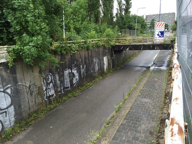
Figure 3: Abswoudestunnel
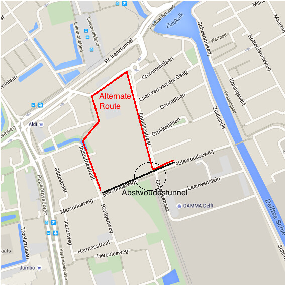
Figure 4: Locus Map of Abstwoudestunnel and the alternate route
A3. Hoventunnel –
The Hoventunnel allows bike traffic to cross under Princes Beatrixlaan and continue onto the cycle track on the far side, which runs along Princes Beatrixlaan. The nearest alternative crossing is half a mile up the road but it does not connect directly into the bike path along Princes Beatrixlaan. The Hoventunnel allows cyclists to avoid crossing a dangerous high speed road and taking a long detour; and connects the bike network on one side of Princess Beatrixlaan to the other.
The downside to the Hoventunnel are similar to the Abstoudsetunnel where the tunnel is not well lit and is covered in graffiti. The same issues, however, are not as common here, which is most likely due to the tunnel being in close proximity to a safer neighborhood. Making the Hoventunnel was a large expense because 1) it is a tunnel and 2) the tunnel had to go under a main road. The alternative to this was to either build a bridge over Princes Beatrixlaan or to create an at-grade crossing. A bridge would be a similar cost to the tunnel but in order to be at an elevation where it would not disrupt Princes Beatrixlaan truck traffic, the up- and down-slope of the bridge would have to rise steeply, or the approach to the bridge would have to be very long to accommodate the height. An at-grade crossing would be a cheaper alternative to the tunnel but it would need to have a traffic signal in order to let the bike crossing be safe and putting a traffic signal on a 70 km/hr travel road is not ideal.
As shown in Figure 5, Hoventunnel allows access to bikes and pedestrians under Princes Beatrixlaan, a busy highway in the area. Without Hoventunnel, cyclists and pedestrians would have to travel far out of the way on winding paths to reach another way to cross Princes Beatrixlaan. The alternate route, as shown in Figure 5, is 1.35 kilometers long which is a walking time of 16 minutes. Hoventunnel allows convenient access for bikes and pedestrians only to cross under Princes Beatrixlaan.
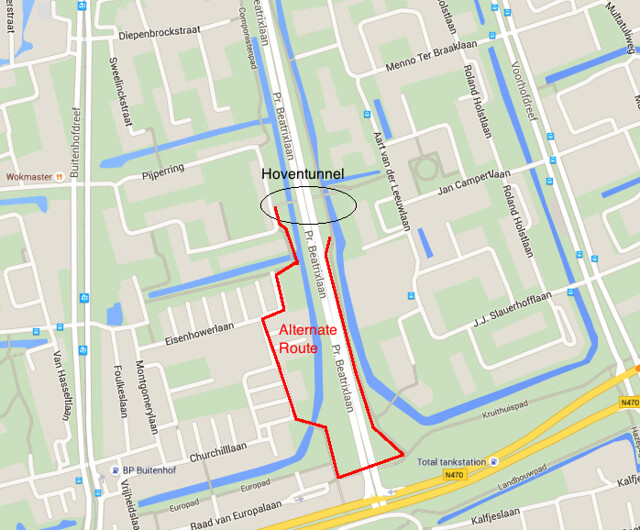
Figure 5: Locus map of Hoventunnel and the alternate route
When the underpass relates to a freeway or a rail line, the decision of payment can reasonably fall to either the highway/rail program or the bike program. Arguments can be made for either side. The highway and rail programs can argue that their railway was there first and should not be involved for the payment of a trail for a different type of transportation. The biking program can also defend that residents were cycling well before the tracks or highway was built and that the structure now hinders this form of transportation. The easiest solution is to work together to fund a safe and effective transportation route, whether a bridge or underpass, to successfully coexist together. Part of the funding for these projects will be funded by the city itself or even the province/state relieving some of the stress of which department must pay for the project.