Topic: Blvd Scheveningen & Continuation of Recreational Bicycle Route
Team: Maggie, Kurt, Stephen
Site Introduction
The village of Scheveningen attracts throngs of tourists, up to 16 million per year. Part of the reason these tourists come to the seaside resort is the vibrant nightlife and the thrilling boardwalk atmosphere. Others come to enjoy the natural beauty of the Dutch coastline. A new bicycle friendly boulevard along the beach was opened in 2013. Tourists and beachgoers can cycle from the pier in the north to the harbor in the south. The current bicycle facilities promote the economy of the region by improving access to businesses and attractions along the coast.
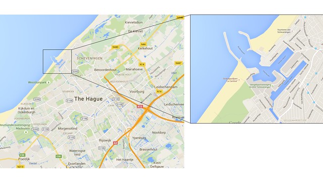
Figure 1. Site Location
Currently, the bicycle facilities are cut off by the Scheveningen harbor, and cyclists who wish to continue their ride down the coastline are forced to circumnavigate around. This route adds about 2 km with plenty of potential for tourists unfamiliar with the area to take a wrong turn. Extending the bike path along the coast to the south would provide a direct route to bypass the harbor and add another dimension to the attractiveness of the region. Bikers would be able to get to Scheveningen from the south while avoiding any contact with car traffic on the roads surrounding the harbor. Inversely, tourists from Scheveningen would have access to the scenic bike ride along the coastal dunes to the south.
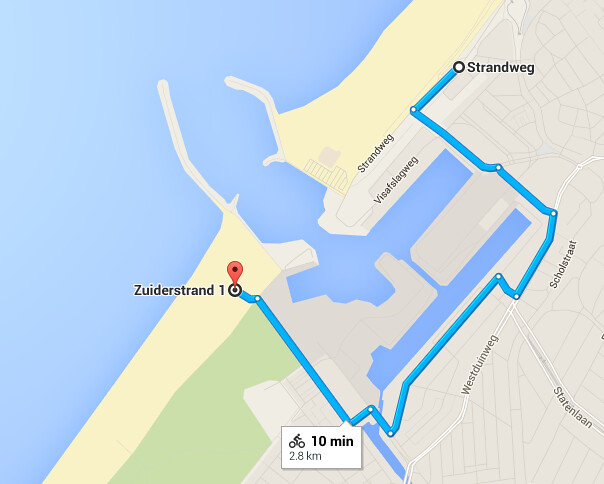
Figure 2. Current Recommended Bicycling Route
Current Port Condition
Scheveningen is a medium sized port split into industrial and recreational sections for sailing vessels and personal yachts. The industrial section can accommodate freighters and reefers up to 140m, while the recreational section typically holds smaller sailboats and some fishing trawlers. The spit design of the port allows for an easy and inexpensive bike crossing in the canal between the two ports by a drawbridge of similar design to the ones that dot the Holland waterways.
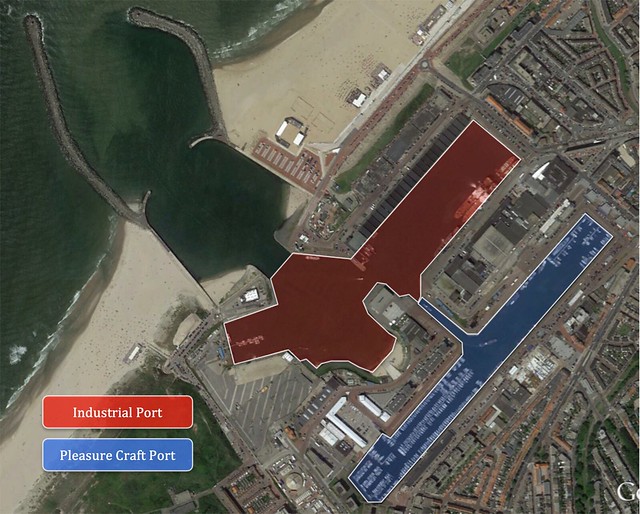
Figure 3. Port Usage Map
Because there is a significant industrial port in the area, the marine traffic is an important consideration throughout the design. The following figures assess this.
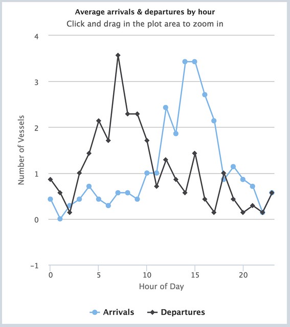
Figure 4. Scheveningen Port Average Arrivals and Departures
The plot in Figure 4 shows the average arrivals and departures by hour at Scheveningen. It easily shows the two rush hours for boats in morning and afternoon hours. The hours of 7-8 for outgoing boats and 14-15 for incoming boats are the most busy and the bridge schedule must consider these peak hours.
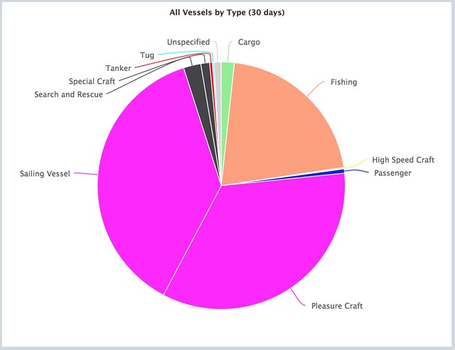
Figure 5. Scheveningen Port Vessels by Type
The types of traffic seen in Scheveningen Port can be seen above in Figure 5. While pleasure craft make up the bulk of traffic at Scheveningen, the drawbridge will allow most fishing and industrial traffic to pass through the port without encountering an obstacle. If the bridge can be constructed high enough, a large portion of the smaller pleasure crafts will be able to pass below, however it will need to open for all sailing vessels.
Design Options
Two locations were considered for the crossing: Design Option 1 at the front of the port between jetty exit and the industrial port (Figure 6) and Design Option 2 at the border of the industrial and pleasure craft port areas (Figure 7). The issue with Design Option 1 is it blocks both the industrial and recreational area whereas Design Option 2 blocks only the recreational port.
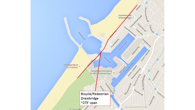
Figure 6. Design Option 1
Option 1 is the obvious continuation of the bike boulevard and would require little change on this end. We considered a raised crossing that would allow sailboats to cross and a rotating cable-staid bridge. The raised crossing was determined to be unfeasible because the necessary 65 foot change of elevation needed to allow sailboats to clear the bridge would have been impossible for cyclists to make climb, even over the 275 foot span. Additionally, the rotating bridge would take a long to allow ships to pass, leaving bikes waiting for longer periods of time.
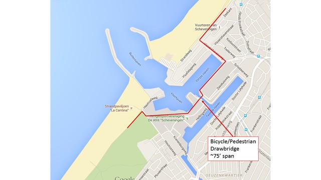
Figure 7. Design Option 2
The group decided that Option 2, with a 75 foot span, would have to be a drawbridge to accommodate frequent opening for boat traffic. Additionally, this bridge is set further back and will only see pleasure traffic. This would need to be raised more frequently but the shorter span would not take as long and provide less delays for both boats and bicyclists and pedestrians. There is still a question of the integration of this route into the existing bike boulevard. There are a few turns required through an industrial area, however the group decided that there is potential for the port to be used as a tourist attraction.
Final Solution
For our final design the group decided on Design Option 2 (Figure 7). This solution places the bridge at the narrow section of port, bordering the industrial and recreational port. This helps in a few ways, one being it allows all industrial traffic to flow through the port without any barrier to the sea. This means some of the most vocal opponents of the bridge would have nothing to protest. While large industrial ships make a small percentage of the over all traffic in the port, they are the ones we want to have full access to the ocean when needed. On the other side, we assume the pleasure craft could just tailor their schedules and days on the water to get back when the port opens and closes without much issue. The weighted drawbridge could also have much faster open and close cycles, meaning shorter weight times for bikes and more frequent openings for sailboats.
Bridge Timing
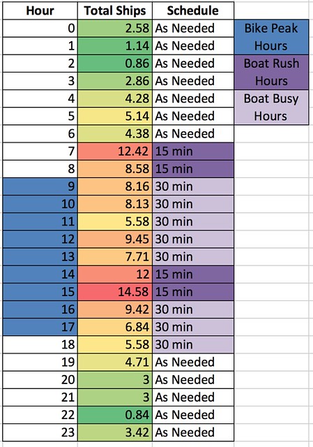
Figure 8. Potential Schedule for Bridge Timing
In deciding bridge signal timing, we consulted the inbound and outbound data for the port and tripled the numbers to account for the ships not tracked online on MarineTraffic.com. This number was found by counting the sailboats in harbor on google maps as well as counting the ships that were being tracked online and finding the difference.
Bike Peak hours are highlighted in blue and boat peak hours are highlighted in the two shades of purple. Boats docking in off peak hours such as the night, are given priority as needed, because there will be few cyclists crossing. For the peak boat traffic times, boats are given an open bridge every 15 minutes to shorten wait times for daytime pleasure cruises. During the day while cyclists are using the bridge and the boats are out at sea, the bridge will only open every 30 minutes. We assume a maximum wait time of 4 minutes for cyclists while the bridge opens for ships.
Connectivity
The connectivity of the existing bicycle boulevard to the proposed bridge design is important. The group values ease of use and the ability to continue the beach boulevard feel. The proposed connection can be seen in Figure 9. As previously mentioned, the bridge will cross between the industrial port and recreational port. The southerly area has some bicycling infrastructure but this link provides access to an area with potential of future development along the beach.
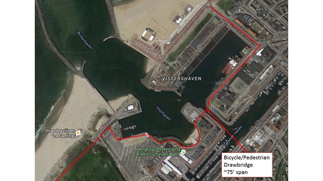
Figure 9. Proposed Map of Connectivity
Conclusion
As seen throughout this post, the Scheveningen bike boulevard could be improved for tourist connectivity. The proposed design is a 75′ drawbridge in the center of the port. Although this is slightly offset from the existing bike boulevard, it integrates the priorities of the current port usage and tourist usage. The design would have less of an impact on shipping while still providing tourist with beautiful bicycling facilities along the beach.