Brighton Ave Redesign: An Affordable Solution (Peter, Katie Merry, Garrett, Sarah)
Allston-Brighton is a vibrant neighborhood nestled between two of Boston’s biggest universities-Boston College and Boston University. Allston Village, defined by Harvard Ave, is a hub for college students and young graduates and has a healthy mix of housing, shops, bars, restaurants, and music venues that are dependent on on-street parking. Brighton Ave marks the Southern edge of Allston Village and is a bustling street that over 25,000 cars use each day (2010, Mass DOT) and includes a bus route that connects Kenmore Station to Watertown Yard and serves over 10,000 riders every weekday (Route 57). Additionally, the B train of the green line stops at Packard’s Corner, the eastern bound of Brighton Ave, increasing the amount of pedestrian traffic.

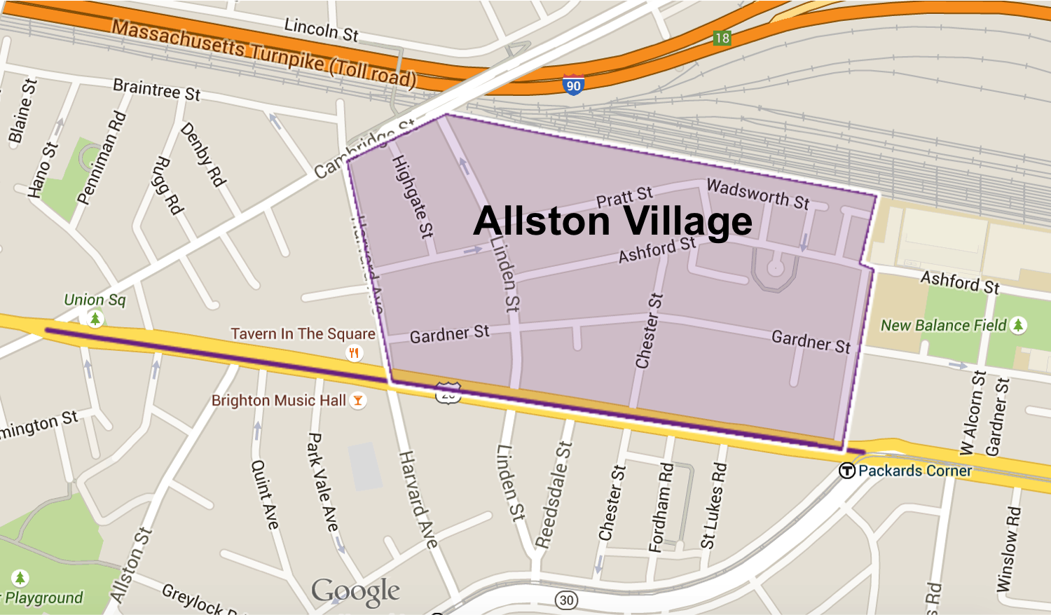
Existing Conditions
Lane Layout
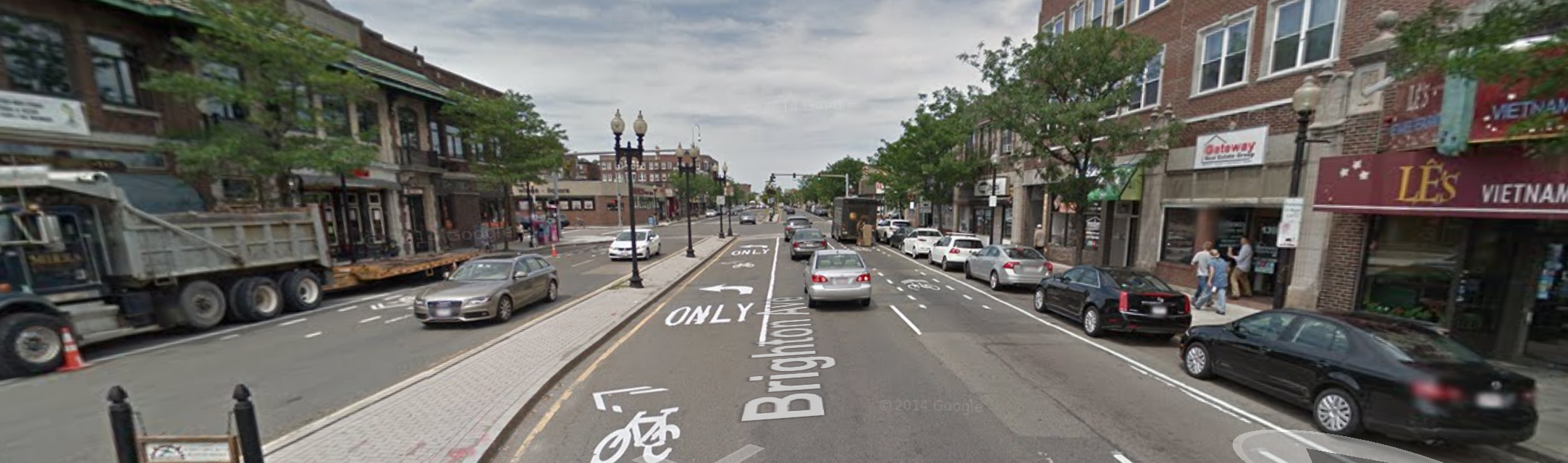
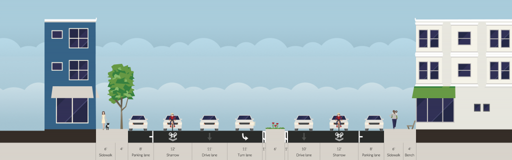
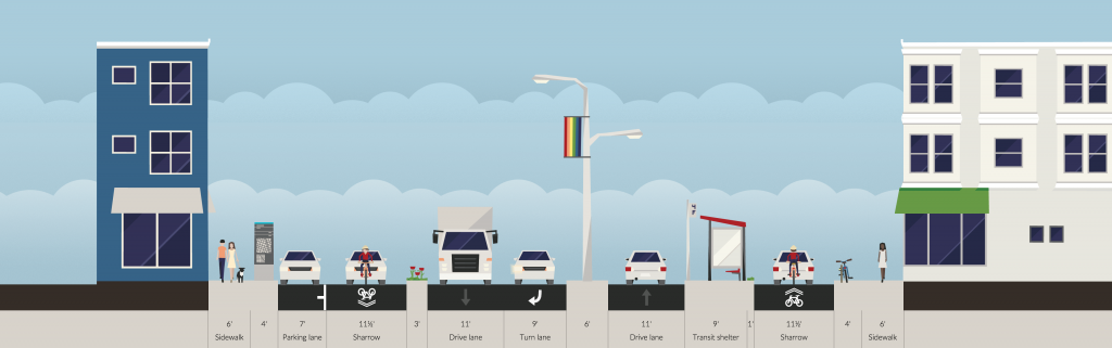
There are currently two 11′ travel lanes with speed limits of 30 mph going in either direction on Brighton Ave, with additional turn lanes when necessary. There are parking lanes on either side of the street that include designated no parking pull-in areas for busses. There’s also a large median running the length of the street that is 18′ wide at its widest point, and transitions into turn lanes when necessary.
Bike Infrastructure
Currently, there are priority bike lanes on either side of Brighton Ave. There are sharrow markings on the pavement as well as a dashed bike lane outline in the middle of the travel lane that indicates the lane is shared between bikes and cars, and that bikes have a designated space on the road. These turn into bike lanes on either side of the road at Commonwealth Ave and just regular sharrows going on to Cambridge St.
Traffic Control Devices
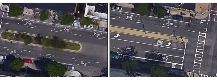
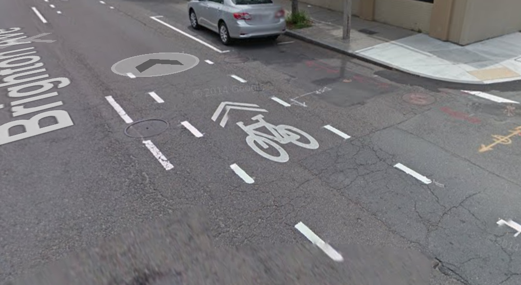
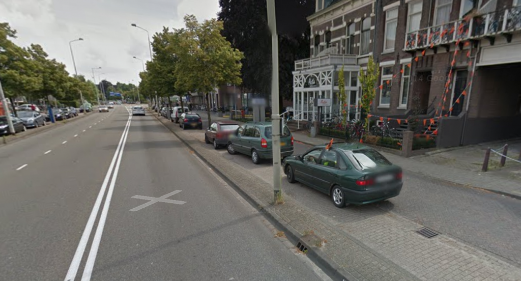
Brighton Ave is situated between two major intersections – Packard’s Corner to the East and Union Square to the West. Aside from these there are additional signalized intersections, multiple T-intersections, and one intersection that utilizes reversing one-way streets as a traffic calming device (pictured).
Goals of Redesign
The main goal of the project was to create an inexpensive design to better the transportation system on Brighton Avenue, between Packards Corner and Union Square. The definition of inexpensive design was that the sidewalks of the street could not moved. However, the curbs of the median could be altered.
- Separate bikes from fast car traffic
- Create a safer shopping area for pedestrians
- Allow bus riders to enter/exit safely, prevent busses from having to exit/re-enter flowing traffic
- Redistribute some of the excess space in median
Proposed Solution
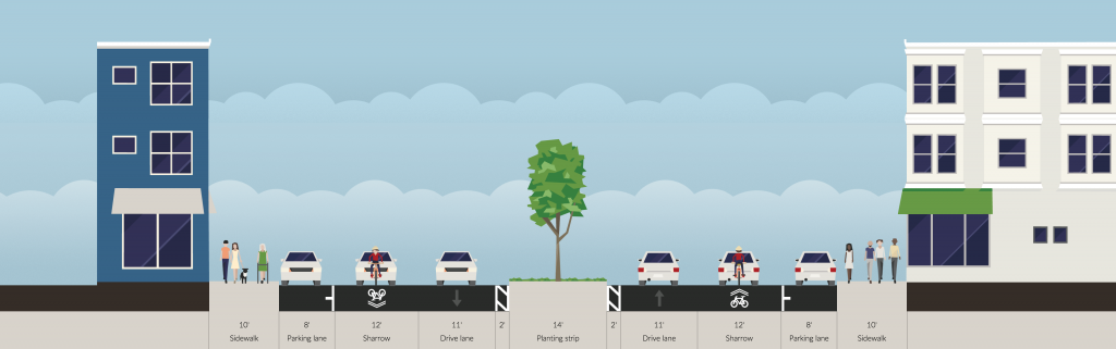
In order to balance the need for car parking, the high volume of thru automobile traffic, as well as separating bike and pedestrian traffic from thru automobile traffic, our inexpensive design is to add one way service roads on either side of of the street with 1+1 travel lanes in the center. The travel lanes will be separated by a median, and the service roads will be shared by local car traffic and bikers.
Proposed Conditions
Lane Layout
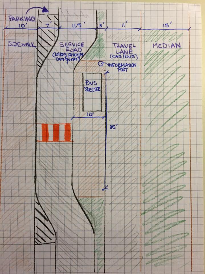
In our proposed conditions we reduced the travel lanes to one in each direction, and added service roads running parallel in either direction. This separation will allow us to achieve our goal of separating fast moving thru traffic and local traffic to businesses along Brighton Ave.
At Packard’s Corner, only one lane feeds Brighton Ave. in the westbound direction from Commonwealth Ave.. In addition, cars are often seen double parking in this area. Those two conditions hint strongly that this section of the road does not need two travel lanes per direction. However, approaches near the intersection of Harvard Ave. are so congested that two travel lanes are necessary. The service road system will be a compromise of the two. It will keep thru traffic separate from local traffic and bikers which keeps bikers safe, as well as alleviating the problem of parking cars blocking traffic.
The 11.5’ width in the service roads will not allow cars to pass bikes, but will allow a bike to pass a car or small truck stopped along the side of the service road. The service road, separated from the travel lane by a median, is considered a “shared space” with low speeds and priority to bikes, influenced by Dutch local streets. Vehicles can enter the service roads at either end of Brighton Ave, as well as at the Harvard Ave intersection. Both service roads include parking. Buses will use the faster, inside road. Bus stops will remain at their current locations, but will be in-line. At bus stops, the median between main road and service road is widened, taking space from the parking lane, to allow for a proper bus stop. We are not currently planning on eliminating any parking, owing to the commercial nature of the area. To see how bikes and cars will exit or enter the service road see the hand drawn sketch below.
The center thru lanes are remaining the same width, and we are reducing the excessive median in order to allow for the service roads on either side. The median will become a turn lane when necessary, the transition back to its full extent. The median will also serve as a pedestrian refuge area at crossings. While we considered alternative designs that would have eliminated the median altogether, due to our parameters as the inexpensive team, we wanted to deliver a design with a consistent cross section.
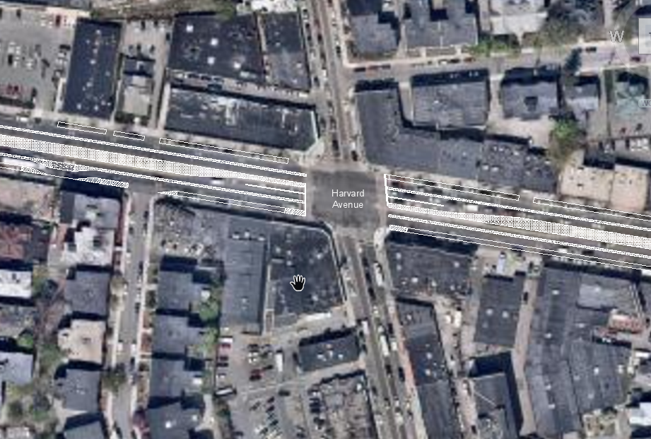
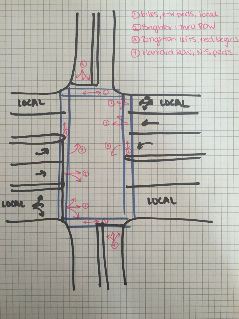
Proposed intersection with Harvard Avenue
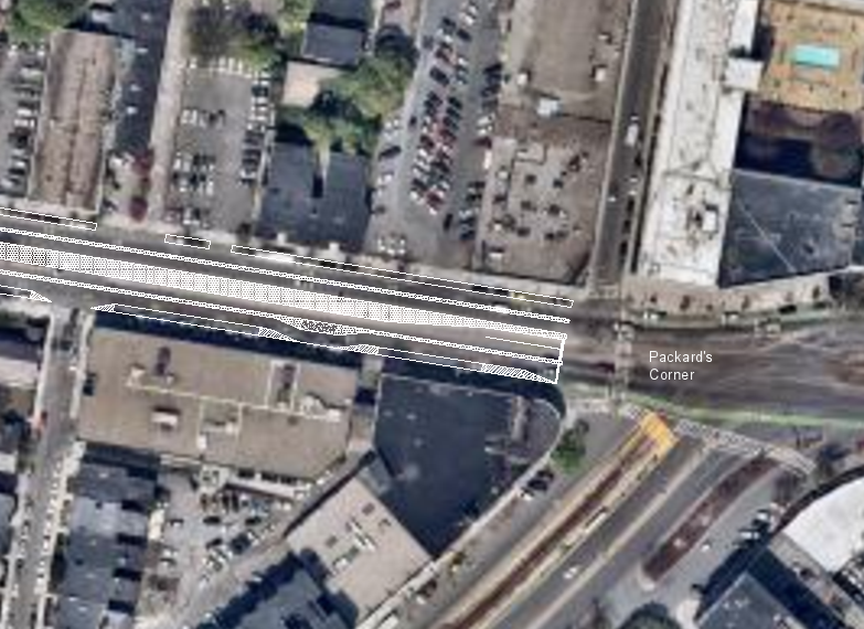
Proposed Packards Corner
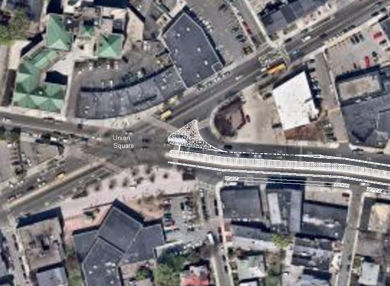
Proposed Union Sqaure
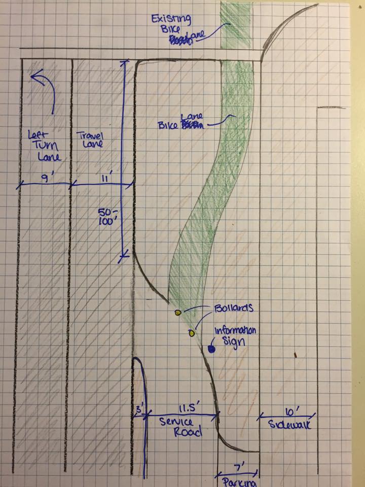
Example of the entrance or exit from the service road at an interesection
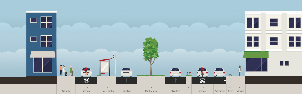
Proposed Cross-section with full median
Proposed Cross-section with left turn lane
Bike and Pedestrian Infrastructure
The service roads will allow bikes to be separated from thru traffic. The service road will be used by cars for parking and accessing residential areas and businesses, allowing bicyclists to have priority. Speeds will be posted at 20 mph to allow for safe travel, no buses will be allowed on the service road. There will be large sharrow markings to indicate that bikes have priority on this road. This shared space will create a more neighborhood-like feel on what is currently a busy thru street connecting Brighton, Watertown, and the Fenway and Back Bay areas. By separating the parked cars from the thru traffic, pedestrians will be able to enter and exit their cars with much less stress than before. In addition, the thru traffic will now be more than 20 ft from the sidewalk which will create a better shopping environment and will welcome more customers to the businesses.
An additional design option is alternating trees with parking spaces. This would create an even more welcoming environment than the proposed design. This option could be brought up to the resident and store owners so that they could put it to a vote. While adding more trees would make the environment better, it would also take away from parking area. The owners and residents could vote to alternate however many parking spaces for each tree.
Bus Stops
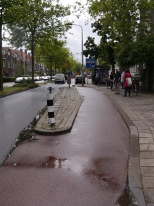
When approaching a bus stop, the buses will stop in the travel lane, completely blocking traffic. At the bus stop, the median between the travel lanes and the service roads will widen to create a platform for transit riders to enter and exit. There will be raised crossings that double as speed humps at all bus stops. In addition, the lane will curve creating a chicane. The first image is an example of bus stop in the Netherlands and the second handrawn image is the sketch of the designed bus stop.
Traffic Control Devices
There are multiple traffic control devices on the service roads. There will be raised crossings that double as speed humps at all bus stops. In addition, the lane will curve creating a chicane. The main deterrent to speed on the service road will be these geometric variables. In the thru lanes the current crossings and signals will remain, but the signalized pedestrian crossing won’t start until the medians on the outer side of the service road, with the central median acting as a refuge area. The service roads will have crosswalk markings near intersections so bikes and cars will yield to pedestrians.
Alternative Designs
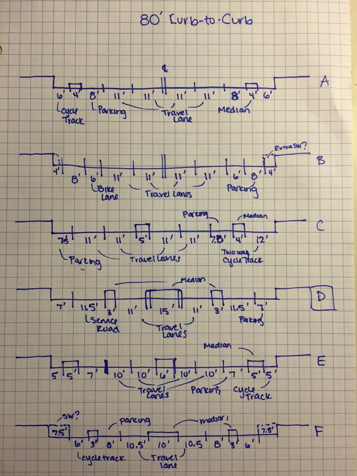
Pictured to the right are some other designs that were considered but not completely hashed out, they include:
The first image is the layout of a design with a two way cycle track on the westbound side of Brighton Ave.
The second image contains multiple street cross sections:
A – Two, one way cycle tracks (no center median) with 2+2 travel lanes
B – Two, one way bike lanes with 2+2 travel lanes
C – One, two way cycle track with 2+2 travel lanes
D – The chosen design with service roads with 1+1 travel lanes
E – Two, one way cycle tracks (with center median) with 2+2 travel lanes
F – Two, one way cycle tracks (with center median) with 1+1 travel lanes

Conclusions
In the end, the service road layout for Brighton Ave. was chosen because it seemed to create the safest environment for all users: pedestrians, bicyclists, public transit riders, and car drivers. The through traffic lane allow a continuous road for car drivers, while the service roads with low traffic volume, raised crossings, and speed humps allow local traffic, bicyclists, and pedestrians to coexist safely. It also allowed parking space to be conserved, which is an important factor for local residents and shop owners. It is possible that another design we proposed in the “alternative design” section could provide a better solution, however given our time constraints and the parameter of keeping it inexpensive (i.e. minimizing the amount of curb changes), the service road layout was the best option for the project.