By David Roglieri, Jenna Bilsback, Anna Guidi, Maddy Wax, Stephen Mais
Introduction:
Adam’s Village, an area in the Dorchester sector of Boston, currently lacks proper biking facilities for cyclists traveling east-west and for connecting to nearby greenways along the Neponset River and (planned) Dorchester Bay. Gallivan Boulevard is a major thru road in the area used for access to I-93 and the Neponset River Bridge, highways connecting Dorchester to downtown Boston and Quincy. Gallivan Boulevard also provides access to Neponset Avenue and Morrissey Boulevard, local alternatives to I-93. Besides use as connecting road, Gallivan Boulevard has a shopping center near Neponset Circle, bringing in local access traffic and resulting in many busy intersections that are difficult for bicyclists to navigate. Furthermore, to bypass these intersections, many vehicles are currently using Minot Street as an alternative to Gallivan Boulevard.
South of Gallivan Boulevard is there is an existing greenway, the Neponset River Trail, that runs along the coast to Boston. This greenway lacks connectivity in the Dorchester area and does not have access into Adam’s Village.
This report considers the possibility of using Minot Street as the main east-west bikeway, as an alternative to Gallivan Boulevard. Minot Street, as seen in Figure 1 and 2, is a local street that runs parallel to Gallivan Boulevard through Adam’s Village. A street view of Minot street is included below in order to provide a feel for the atmosphere on the road.
Minot Street was designed to access homes along and close to Minot Street. Since it is a residential area, the street should be designed to prevent through traffic, limiting the speed and amount of cars. The existing design limits this traffic to some degree by alternating one-ways sections on the road; however, it still allows cut-through traffic using Hallet Street as an entrance from Gallivan that allows them to bypass the signalized intersection at Adams Street and Gallivan Boulevard. See Figure 3 below, which shows the locus map of the area surrounding Minot Street and Gallivan Boulevard, and Figure 4, which shows the path that vehicles use to bypass the lights at the intersection of Adams Street and Gallivan Boulevard.
As shown in the images below, Gallivan Boulevard is a highly commercialized area causing increased road congestion as there are multiple shops and big box stores in the orange areas. Minot Street is very residential and is ideal for bicycle and pedestrian traffic as shown in Figure 2 as well. In order to get a clear overview of the streets, an additionally viewed map is also included below in Figure 5.
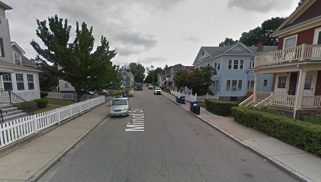
Figure 1. Street view image on Minot Street.
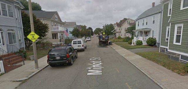
Figure 2. Street view image on Minot Street.
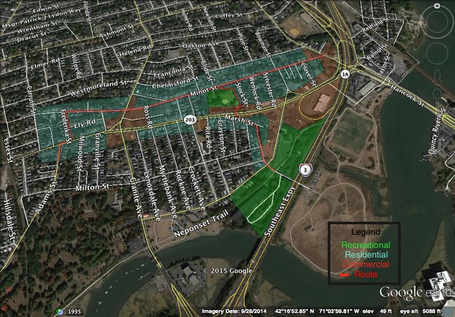
Figure 3. Is a locus map of the network of roads to be redesigned.
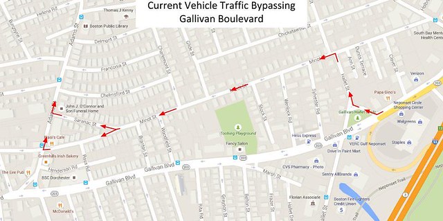
Figure 4. Vehicle traffic flow from Gallivan Boulevard to Adams Street.
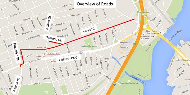
Figure 5. Provides an additional vantage point of the streets to be redesigned.
Areas of Concern:
When studying Minot Street and the surrounding areas, we highlighted several locations that would need to be addressed to increase bicycle safety in this neighborhood and calm traffic. These areas are circled in Figure 6 below.
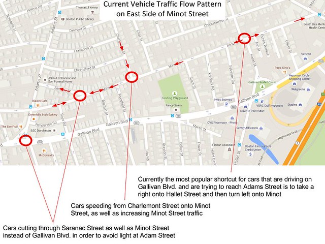
Figure 6. demonstrates the existing areas on the route where bicycles safety is not a main priority.
Existing Conditions:
The portion of Minot Street to be redesigned is the stretch between Neponset Avenue on the east and Adams Street south of Gallivan Boulevard on the west. In order to fulfill the connectivity of the bike path, a few other roads are utilized including Frederika Street and Gallivan Boulevard.
The width of Minot Street, curb to curb, is approximately 26 feet along its entire length. Parking is permitted on either side of the road, but there are no markings to designate its separation from traffic. Figure 7 below shows the approximate dimensions of the existing cross section. The entire street is made of asphalt, a material that is conducive to high speed traffic. As can be seen up above in Figure 2, there is very little greenery and almost no trees on Minot Street, despite it being one of the best neighborhoods or Dorchester. There are a few existing measures that have been taken in order to reduce speed and traffic on the street. For example, the majority of the length of Minot Street is one way. The only portion that is two way is in the small commercial area between the Saranac Street fork (east) and Adams Street (west). Despite these measures (and the direction change at Hallet Street mentioned earlier), it is clear that cars are still speeding through this residential area, as can be seen by the “Drive Slow” signs in Figure 2. The traffic flow patterns are featured in Figure 8 below. The entirety of the street is fairly straight with frequent road intersections. At each intersection, travelers on Minot Street have priority, making it the main road for the neighborhood traffic, and a convenient and quick path for through traffic to bypass the Gallivan Boulevard and Adams Street intersections.
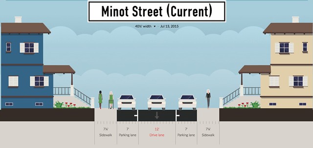
Figure 7. Is a cross section of Minot street which includes the estimated dimensions for cylists traffic, vehicular traffic, and stationary vehicles.
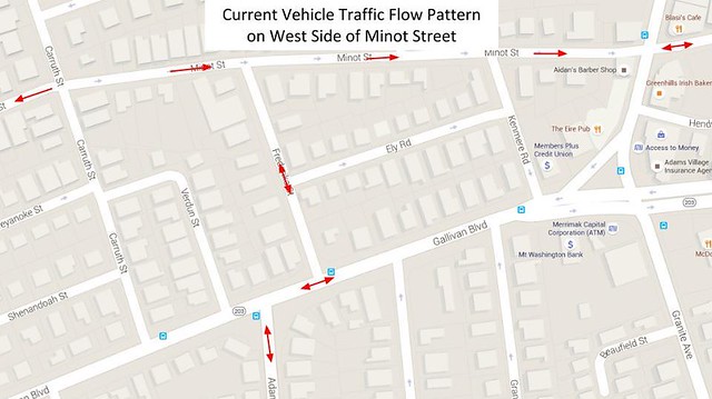
Figure 8. demonstrates the current traffic flow patterns on Minot street.
Frederika Street is connected south of Minot Street. It is a residential two way street with parking on both sides. The curb to curb dimensions is 26.5 feet. Similar to the layout on Minot Street, there is no designated lanes separating the parked cars, bike traffic and vehicular traffic. Figure 9 below represents a general cross section of the street. Because of its short length, Frederika Street is only intersected by one road, a short neighborhood one way. It consists of the same materials as the surrounding streets, asphalt.
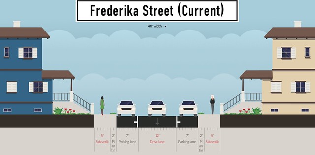
Figure 9. is a cross section of Frederika Street, a key linkage in the connectivity of the bike route.
A short portion of Gallivan Boulevard is utilized to provide the missing link between Fredrika street and the lower portion of Adams Street. Gallivan Boulevard is a busy, four lane asphalt street. The cross section is included in the figure below.
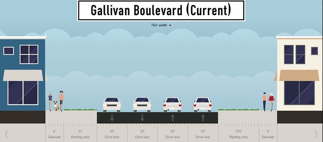
Figure 10. provides a visual for the cross section of Gallivan Boulevard, where our route crosses from Frederika Street to the southern portion of Adams Street.
Goals of Redesign:
1. Bicycle Network
One of the main goals in redesigning Minot Street is to expand upon the existing bike network in Boston. Increasing the number of bicycle friendly paths will help to raise awareness and participation in this mode of transportation. An essential aspect of these routes is connectivity, which allows more bicyclists to access the routes, and more locations to be accessible by travel on the routes. The redesign of Minot Street aims to improve the linkage between large residential neighborhoods (between Minot and the lower portion of Adams Street), and a convenient bike roadway, the Neponset Trail.
2. Street Demotion
Since Minot Street is a residential area, a street demotion would not only benefit cyclists, but also the residents in the area. Demoting the street will help to change the atmosphere of the area, discouraging cars from using it for any other purpose other than for local access. In order to make it appealing route for cyclists and to increase acceptance among the community, the demotion includes a promotion of greenery along the street. The goals of street demotion change the atmosphere from a car-oriented area, to a place where bike and pedestrians are the kings of the road. In order to accomplish this, the direct route from Hallet Street to Adams Street via Minot Street must be addressed without causing increased traffic on other local roads. Also, speeding needs to be addressed. Figure 3 shows two yellow advisory signs regarding cars speeding on Minot Street. Residents are looking to allay speeding on their road as there are yellow advisory signs approximately on every block of Minot Street.
3. Add Greenery
As part of the bicycling experience, Minot Street should be transformed into a proper greenway. As seen in Figure 1 and 2 above, the street is completely barren of trees along the roadway. This local street has very small lawns, providing a very barren experience when walking down the road. As part of the redesign, greenery must be added to the street to help give locals back their space. Trees and grass will make the neighborhood more enjoyable to walk or ride through and help neighbors feel like the street is still an extension of their yard.
Proposed Design:
Our redesign includes several aspects.
- To reduce traffic through Minot Street, one lane of parking will be removed from the street and replaced with a 4 foot tree line.
- Traffic will only flow in one direction at any time, except when it is required to be two-way due to an added greenspace intended to block vehicle through-traffic.
- Bicycle traffic will be two-way at all times, with bicycles traveling in the direction of vehicle traffic sharing the travel lane with cars, and bicycles traveling in the opposite direction using a dedicated contra-flow lane.
- On Frederika Street, which will be used to connect Minot Street to the southwest portion of Adams Street, advisory bike lanes will be implemented to maintain two-way vehicle traffic and parking, but reducing the speed of the cars.
- A two-way cycle track will be added along a small portion of Gallivan Boulevard between Frederika Street and Adams Street and bicycle crosswalks will be added crossing Gallivan Boulevard to safely connect the networks.
- Crossing refuge islands will be added to the crosswalk at the intersection of Adams Street and Minot Street to also decrease risk associated with bicycle travel on Minot Street.
1. Alterations in Traffic Flow Patterns
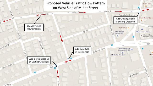
Figure 11. Proposed vehicle traffic flow pattern on the west side of Minot Street.
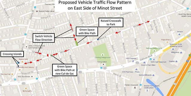
Figure 12. Proposed vehicle traffic flow pattern on the east side of Minot Street
2. Bicycle Network
Minot Street Alterations
For Minot Street, from Neponset Street to just past Branton Street, people biking in the direction of vehicle traffic are guided by sharrows, indicating that the majority of the road is a shared space, and people bicycling against traffic have their own contraflow lane, painted green with white arrows in the direction in which cyclists will travel. On the north side of Minot Street, 4 feet of previously paved road space will be converted to a tree line, changing the overall feel of the neighborhood from a thruway to a homey, park-like atmosphere.
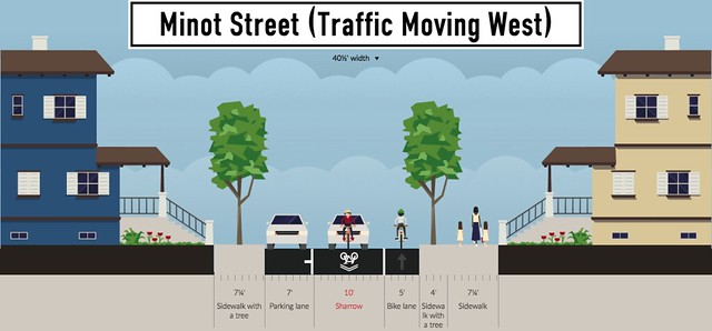
Figure 13. Proposed cross section at Minot Street with traffic heading west.
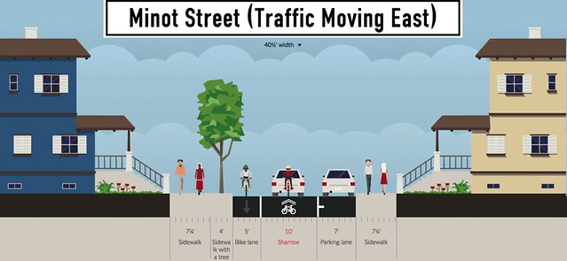
Figure 14. Proposed cross section at Minot Street with traffic heading east.
At the intersection of Hallet Street and Minot Street, vehicle traffic flow moves in opposing directions, similar to the alternating one-ways seen in Rijswijk, Netherlands. Where the streets cross will be a raised intersection to reduce vehicle speed, and two advisory bike lanes will be delimited on either side of the street with white dashed lines to indicate the change between contraflow lanes and shared roads for the bicyclists. The contraflow lanes on either side turn into a painted green line, and the other two advisory bike lanes disappear, but are replaced by sharrows, so that cyclists have constant guidance and are assured that they are still on the Minot Street bicycle network path.
This design of opposing contraflow lanes on the same road can be referred as counter contraflow lanes, and contraflow lanes change sides and directions at the intersection. We were not as worried about bikes moving with traffic but with the unique design of multiple one lane direction parts of the same street, so we decided to implement the counter contraflow lanes to reduce the risk of a head on collision. Parked cars are on the opposite side of the contraflow bike lanes so there is no danger of dooring. An example of a contraflow bike lane that was successfully implemented is shown in Figure 17. On Netherlands Avenue in Boston MA, there is a separate lane for bikes that flows in the opposite direction of traffic.
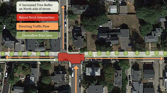
Figure 15. Proposed intersection on Minot Street.
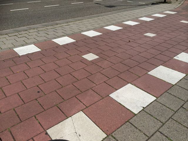
Figure 16. Dutch inspired raised intersection.
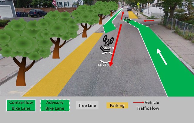
Figure 17. Use of contraflow lanes on Minot Street.
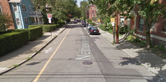
Figure 18. Implementation of a contraflow bike lane on Netherlands Avenue in Boston, MA.
In the Netherlands Contra Flow bike lanes are used readily in many parts of the country and have shown to lower risk of head on collisions. This design feature separates on coming traffic from bikes attempting to go the opposite direction on a one way road. Contraflow is very helpful in roads that have been cut down to one direction but serve high number of bikes in both. They can allow bikes to make a direct route without staying on the main distributor roads. This example shown in Figure 19 below is on Weteringlaan west of Delft city center.
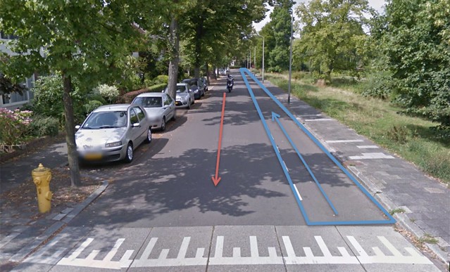
Figure 19. Contraflow bicycle lane on Weteringlaan in Delft.
3. Permeable Barriers, Direction Change, and Greenery
In order to eliminate thru traffic from Gallivan Boulevard to Adams Street via Minot Street, we looked at different Dutch techniques we could apply, and at other instances in which there was a successful street demotion. One way to deflect traffic is by changing direction of traffic and creating permeable barriers, which we saw implemented successfully in the Da Costa neighborhood in Rijskwijk. We tried to emulate this by changing the direction of traffic in several instances.
Saranac Street, a residential street off of Minot Street, was being used by cars to avoid the sharp right turn from Minot Street onto Adams Street, so we switched the direction of car traffic such that this turn was no longer an option and vehicle traffic flowed southeast away from Gallivan Street. Additionally, vehicle traffic flow was changed from two-way to one-way moving west on the segment from Saranac Street to Ross Road on Minot Street. In order to fully block vehicle traffic from passing through Minot Street from Gallivan Road to Adams Street via Hallett Street and Minot Street, a greenway was placed at the fork in the road at Saranac Street and Minot Street. This greenway has two bicycle paths so that bicycles and pedestrians may continue to the residential area of Minot Street, but vehicles are physically blocked from either side. The segment of Minot Street between this greenspace and Branton Street remains two-way so that the homes along Minot Street can be reached.
An additional greenspace was added along the southern part of Charlemont Street at Minot Street, again with a bicycle lane to allow through traffic to non-car travelers. This greenspace disconnects the northern neighborhood from Minot Street and further discourages vehicles from entering Minot Street as a means to bypass Gallivan Boulevard.
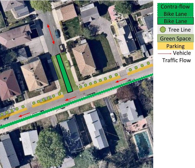
Figure 20. Proposed intersection of Minot Street and Charlemont Street.
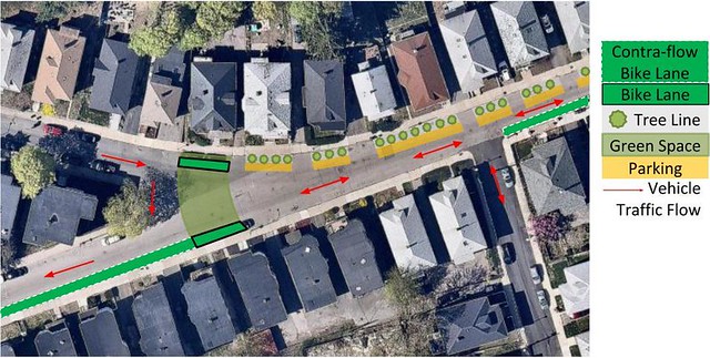
Figure 21. Proposed intersection of Minot Street and Saranac Street.
4. Neponset Trail Connection
With the goal of increased bicycle greenway connectivity, we decided to connect not only bike facilities but integrate existing parks into our design giving the community better access to both transit and recreation. Under our redesign of Minot Street, we are expecting increased bike traffic with a greater need for connectivity to existing Boston greenways. The length of Minot Street and the extensive number of cross streets allows for many different connectivity options to the Neponset Trail and Pope John Paul II Park. Looking at the multiple options, two routes came into focus as the best designs. One route is the shortest and most direct route to the trail but crosses through a major intersection on Neponset Ave, and would require major street design changes and lane closures to offer the necessary level of biking separation. The second makes use of the existing Toohing Playground to connect to the Neponset trail. We plan to construct a separated bike path around the park and connect to residential roads south of Gallivan Boulevard.
This plan both avoids the dangerous Neponset Avenue intersection, but avoids building on private land. While this route serves dual purposes connecting the biking infrastructure and existing park space it unfortunately adds roughly 1,600 feet of increased distance compared to the direct route. The park route also utilizes existing paths south of Gallivan Boulevard in the construction leading to lower cost and decreased impact to neighbors through construction. The route is comprised of mainly residential roads and trails perfect for a low stress bike connection. The connection also makes use of existing crosswalk infrastructure on the south end of Toohing Playground further reducing cost and complexity in the project. Keeping Neponset Avenue untouched and avoiding major construction with existing roads, this plan improves needed connectivity but at a low cost.
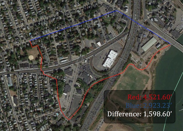
Figure 22. Difference between possible route connections.
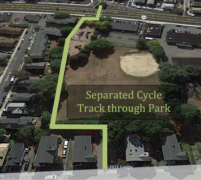
Figure 23. Path of the separated cycle track through the park to connect to Neponset Trail.
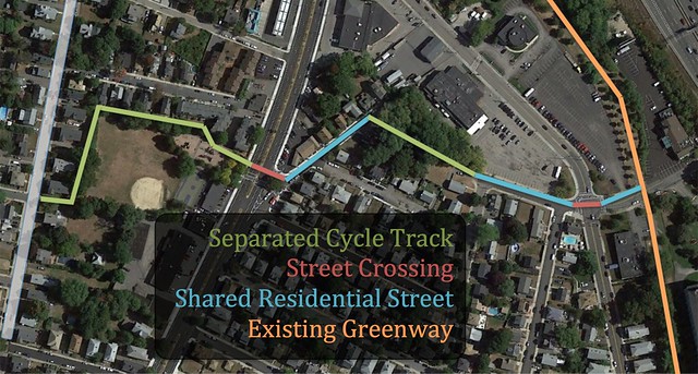
Figure 24. Path connection from Minot Street to Neponset Trail.
5. Street Demotion
At first we wanted to create a cycle track by taking out parking on one side of the street, but we realized that if we put in sufficient traffic calming measures and changed the street flow, we could create an environment where bicycles can share the street with cars while feeling relaxed and as though they have equal ownership of the road. In a quiet residential area, a physical separation should not be necessary, so instead of creating a cycle track, people biking with traffic will be guided by sharrows, and people bicycling against traffic will have their own lane, painted green. Not creating a cycle track gives us more space, of which we decided to dedicate 4 feet to trees. This will beautify the neighbourhood and can help win over the residents that are not as enthusiastic about bicycling. We believe the extra buffer of trees and sidewalk will go a long way into convincing the neighborhood we are on their side and doing good things for the neighborhood and the people that live there.
The main challenge is that Minot Street is relatively long (1,600 meters), and spans from Neponset past Adam Street, so it easy for cars to want to speed through the street in order to circumvent traffic and traffic lights. Our goal is to discourage throughput of traffic by means of a major street demotion and the implementation of greenway barriers permeable only by bicycles and pedestrians.
6. Raised Intersections
In order to slow vehicle traffic even more, we considered adding frequent speed humps, but after noticing how many raised intersections we were putting in (which we first experienced in Delft’s woonerven), we decided speed humps would be unnecessary. We designed for 5 raised intersections total, in locations where cars are tempted to speed off of Gallivan Boulevard and take quick turns onto Minot Street. This design increases car’s awareness of crossing traffic, and pedestrians can continue walking at their same elevations, without a curb to step off.
7. Adams Street Connections
As Minot Street approaches Adams Street North in the western direction, it is bicycle boulevard, with minimal vehicle flow allowed in two directions. Previously, there was not a traffic light at the intersection of Adams Street and Minot Street, showing that pedestrians and bicyclists have had no significant issues crossing the intersection. In order to allay any difficulties in crossing we have added refuge islands on Adams Street to allow cyclists and pedestrians to cross one lane at a time, as shown in Figure 25.
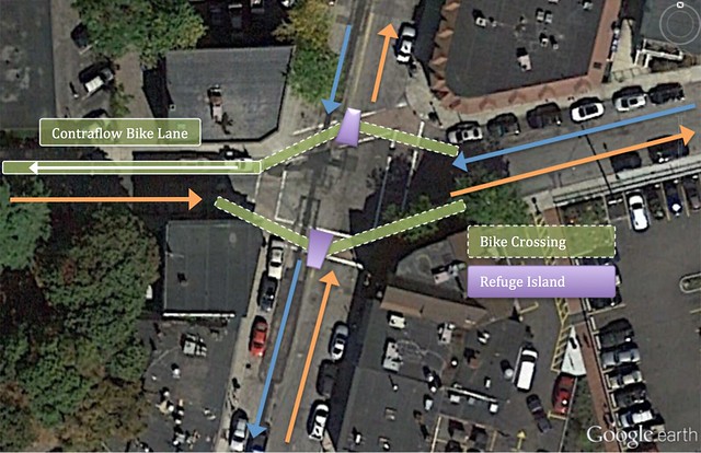
Figure 25. Proposed Minot Street crossover of Adams Street.
After cyclists cross Adams Street, the western section of Minot Street will resume the same traffic flow patterns with contraflow bike lanes heading west on the north side of the road and a shared road heading east. After two blocks, arrows will be used to signify that the bike pathway turns left down Frederika Street. In order to provide a safe biking area on Frederika Street, which has car movement in both directions, advisory bike lanes will be used. With a small center area for cars (4.5 feet), drivers will be encouraged to drive slowly down this local road as they will be sharing the area with cyclists.
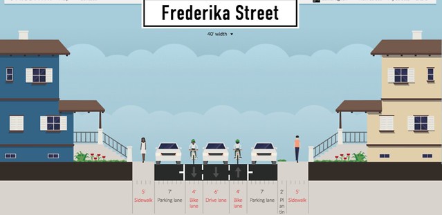
Figure 26. Proposed Frederika Street cross section.
As shown in Figure 27, once Frederika Street reaches Gallivan Boulevard, cyclists are encouraged to ride on the separated cycle track. This cycle track will utilize existing green space to allow safe bike travel along this busy intersection. Southbound traffic will continue on the cycle track until they hit Verdun Street. Existing traffic signals will be utilized to provide safe passage for cyclists across Gallivan so that they can continue southwards on the proper side of Adam Street. Northbound traffic will be crossing the Adam Street right turn lane by utilizing the Dutch design of a pocket bike lane. Here cyclists will use the same traffic signal as the cars turning left allowing for safe travel across Gallivan to the cycle track.
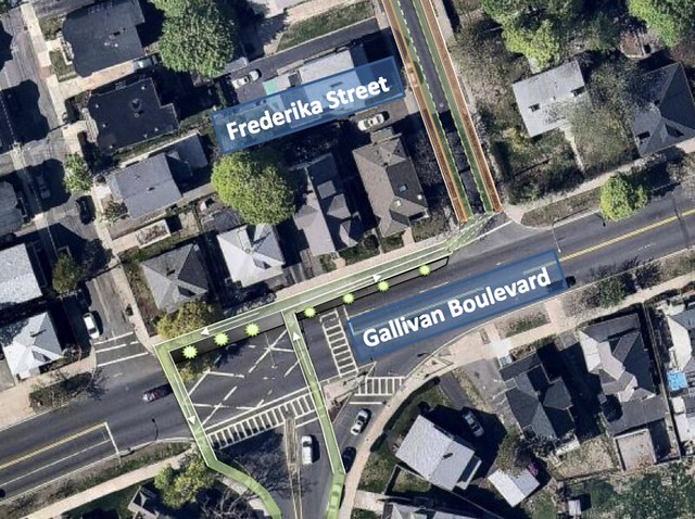
Figure 27. Connection of Frederika Street to Gallivan Boulevard including pathways.
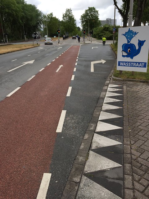
Figure 28. Example of a pocket bike lane.
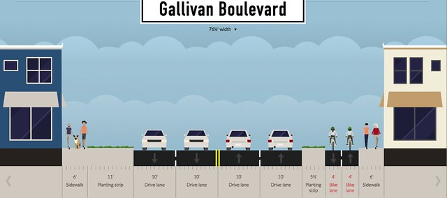
Figure 29. Proposed Gallivan Boulevard cross section.