The Northereastern University maps application is designed to work in a full browser for a computer, in a tablet browser, and in a small mobile device browser.
It should therefore be possible to use these maps with whatever device you have and in any location where you have internet connectivity.
This help page is also formatted to be viewable on a small mobile device.
Back to the NU Maps Application
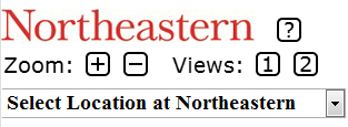
Here is a snapshot of the controls:

We now discuss each control.
This is a dropdown menu for the location of buildings, plazas, and parking areas.
The first two menu items are:
If you select either option, you will go to a map that is centered in the plaza in front of Snell Library.
The other options are ordered alphabetically. If you click on any choice, you go to that location on the map and you are automatically zoomed in.
The parking areas are grouped together and begin with Parking.
The logo
![]()
is a link to the Northeastern home page.
|
|
Link to this help page. |
These controls permit you to zoom in or out.
|
|
Zoom in one level. |
|
Zoom out one level. |
These controls permit you to select the number of map panels.
|
|
Show 1 map panel with a roadmap. |
|
|
Show 2 map panels, one with a roadmap and one with a satellite
image that includes labels.
The maps in the 2 panels are synchronized in the sense that they show the same area if one map is moved or if both maps are zoomed in or out. |
Below we provide snapshots of the same location in the same sized screen area with 1 map panel and then with 2 map panels.
1 Map Panel:

2 Map Panels:
